
Intro
Your journey to the top of Cammerer will begin on Chestnut Branch Trail, which runs beside a picturesque creek plunging its way through a rhododendron filled holler for the first mile and half. You will share this section of trail with a group of stoic, old-growth oak trees which were lucky enough to survive the pre-park logging rush of the 1930s. Turning right, and leaving the creekside, the trail gains in elevation towards the ridge line and its intersection with the Appalachian Trail.
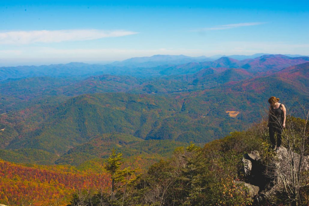
What Makes It Great
This intersection is clearly signed and from here you’ll follow the AT south for three miles to the Mt. Cammerer spur trail. After two miles on the AT, there’s a photo-worthy rock outcropping on your left that overlooks the Big Creek water shed. Continue to climb through a fragrant grove of large hemlocks and balsam fir. Upon gaining the ridge line, you’ll will see a clearly-marked intersection for the spur trail that leads to the summit of Mt. Cammerer and the lookout tower. Take your time and relish the last .6 mile of easy trail to the summit as you capture sneak peeks of the views through a tunnel of mountain laurel. A short scramble up an easy rocky section allows your first glimpse of the lookout tower and its 360 degree views.
Who is Going to Love It
Hiking to the lookout tower at Mt. Cammerer is for people who like burly climbs and big views.
What to Bring:
Trekking Poles: The Smokies are notorious for rocky terrain that is perpetually slick from the area’s rain forest like climate. Throughout the hike, your eyes will wander from the beautiful flora to the long range views. Bring your sticks to avoid a slip whilst distracted by such beauty.
Time Lapse Camera: The lookout tower was positioned to have expansive views of the area. A clear view to the east and west make this a prime location for sunrises and sunsets.
One Extra Hour: Start your trip a little early, pack a quality lunch, and take your time to drink in the views from this airy perch.
Tips from a Local:
Climbing Cammerer during the weekdays or in the winter months will give you a chance at solitude on the summit of this highly visited peak.
The giant hemlocks of Appalachia are quickly disappearing due to climate change and an invasive species known as the wooly adelgid. Several large, healthy trees are still living along this trail. Give one a hug and take a picture; one day you can show your grandkids how magnificent these trees once were.
Directions, Parking, & Regulations
The most scenic access point to this peak from Asheville begins from the Big Creek Ranger Station.
From Asheville, drive west on Interstate 40 to the North Carolina/Tennessee line and take exit 451 for Waterville. At the stop sign take a left, cross the large concrete bridge over the Pigeon River and veer left onto Waterville Rd.
Enjoy the close up views of the Pigeon River and be entertained by throngs of rafters in the summer months as you drive on Waterville Road for two miles towards a 4-way stop.
Follow the signs for Big Creek as you continue straight through this intersection. In .2 mile, the Big Creek Ranger Station and your trailhead will be on your right.
Bathroom facilities, trail maps ($1 donation), and overnight permits are available at the Big Creek Ranger Station.
Featured image provided by Logan Mahan


