Posts

As a locally owned business that’s committed to getting people outdoors, we think it’s important to support brands that are doing good for the environment and our society as a whole. One of our favorite pack brands, Osprey Packs, has been making bombproof packs for over 40 years.

Why We Love Them

Wondering how making bombproof packs translates into an eco-friendly move? Buying a high quality item once, significantly reduces your waste and therefore your carbon footprint (and it’s not too bad for your budget either). Osprey does durable packs like no other brand. They’re so confident in the quality of their gear that their warranty covers damage for any reason for an unlimited period of time. 5, 10, 15 years from now you’ll still be able to rock your Osprey pack on any adventure.

Our Top Product Picks

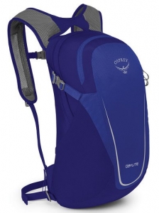
Osprey Daylite Pack – $50.00

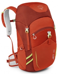
Osprey Jet 18 Kids Pack – $60.00

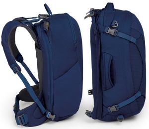
Osprey Duplex 60 Travel Pack – $220.00

A couple weeks ago I posted a blog about the 7 principles of Leave No Trace when hiking, backpacking, and camping: Click here to see blog post. This week, I am following up on that topic. I interviewed Zane Wolf, who used to work for the Forest Service. He had some awesome tips and insights on how to effectively care for the environment, prevent damage, and enjoy it simultaneously!

man with a mustache smiling

Zane Wolf

Question: What were the top mistakes you saw people make in regards to LNT (Leave No Trace)?

The answer Zane gave surprised me, but made so much sense. He said, “Leave No Trace has a kind of polarizing effect when it’s used unhealthily. You can see somebody who’s not practicing a LNT principle, and you could jump down their throat about it…but that isn’t going to solve anything. If you approach them in a healthy manner and give them some pointers on what they could do better in the future without being confrontational and rude, you are perpetuating a true outdoor steward lifestyle far better than if you were to act like an elitist.”

If we want to protect our environment, then we have to be aware that sometimes our attempts might come off as judgmental or confrontational. No one wants to be lectured, so if you see someone not abiding by LNT, take a moment to be sure your words won’t sound argumentative.

Question: What was the most shocking effect of people not practicing LNT that you saw while working for the Forest Service?

Nothing could have prepared me for the answer that came out of Zane’s mouth. While working on the Forest Service, Zane got a call from some hunters asking if they could shoot an elk with a tracking collar. The hunters were told that was fine, but to return the tracking collar to the Forest Service. Not long after, Zane recalls, “they called us back and told us that the elk didn’t actually have a tracking collar on at all, but that it was a toilet seat.” He said that when they saw the elk’s body, the skin on it’s neck had grown around the seat. This meant that the poor animal had been living with this for over a year. It’s hard to think about something like this happening, but it’s important to realize the damage we can cause if we don’t practice LNT principles.

male elk in a field surrounded by female elk

Question: What LNT mistakes are often made that create more of an issue than people realize?

Something that Zane saw all too much of during his time with the Forest Service was people failing to hike and camp on durable surfaces. Most hikers who don’t know about LNT often assume that going off trail, or pitching a tent wherever they see fit, couldn’t cause THAT much damage. Unfortunately, it really does effect the environment significantly. Zane gave a great example of these effects on trail switchbacks. Because water flows downhill, switchbacks are put in place for shedding water as slowly as possible. This reduces the amount of sediment being taken by the rain. When people hike up a mountain and go off of the designated switchback trail, it defeats the purpose entirely. The less functional a switchback becomes, the more vegetation is killed. This then forces animals to move down the mountain for food. When that happens, the population of animals forced to relocate is often decimated by hunting. Again, a sad reality, but an important truth to remember.

Question: What are some of your tips and tricks for effectively and easily practicing LNT?

Zane stressed the importance of principle 5, which is to minimize campfire impact. As I discussed in the last LNT blog, it’s always best to not use a fire at all. Instead, try to use a camp stove, which will automatically leave no trace. If you do build a fire, here are a few pointers from Zane:

  1. Make sure to put the fire in a hole that is at least 7 inches deep if there is no pre-existing fire ring.
  2. If you are in an environment/climate that allows you to burry your fire to put it out, there is a specific way to do this. Zane said that if you stick your hand in the dirt and it is still hot, then the fire isn’t sufficiently put out.

Campfire at night

Another way Zane likes to use LNT is in his personal life. This viewpoint is one I hadn’t thought of, but really love. Here are a few of his methods for applying the LNT mindset to your everyday life:

  1.  “As far as traveling and camping on durable surfaces, that applies directly to building a foundation with your life upon something that you know is sound.”
  2. “You can plan ahead and prepare, and make a good life plan. You can be prepared for what the consequences may be if you decide to go out on a limb.”
  3. “Minimizing campfire impact, to me, applies directly to burning bridges. Don’t burn a bridge that you might need someday.”
  4. “Disposing of waste properly is something that applies directly to your mental health. Don’t stuff something down in a corner emotionally where it doesn’t need to be. If you need to dish something out, then dish it out right then in a healthy way instead of letting it fester.”


I’m really glad Zane agreed to do this interview, and am happy to say I gained a lot of valuable information and advice. My hope is that I can spread this insight to all of you. If you can adopt the LNT principles, both on and off the trail, then your relationship with yourself, others, and the environment will be more fulfilling and enjoyable.


Intro

Delving into the etymology of Charlie’s Bunion reveals a historical tale of exploration during the earliest days of Great Smoky Mountains National Park. Famed author and adventurer, Horace Kephart, was leading a reconnaissance trip high into the remote Saw-tooth region of the Smokies. This knife-edged ridgeline runs between the Mt. LeConte and Mt. Guyot massifs; its airy undulations are some of the most remote parts of the Park — and a profile view of the 10 mile stretch of peaks resembles the serrated edges of a saw. Warn out from the rigors of exploration Kephart’s companion, Charlie Conner, removed his boots during a break and revealed a set of haggard feet. His mangy extremities resembled the nearby bulging outcropping of rocks known then as Fodderstack. Kephart, one of the Great Smokies’ greatest advocates, proposed renaming the rock Charlie’s Bunion to commemorate his misery.

What Makes It Great

Charlie’s Bunion can be reached by a 4-mile hike on the Appalachian Trail. A picturesque drive to Newfound Gap (sight of the Park’s inauguration) leads to the start of this scenic hike. Forests of fragrant firs line the rocky path and long range views will entertain your eyes as you make your way north on the AT. This particular section of the AT has a total elevation gain of 1,600 feet and climbs to over 6,000 feet on the sides of Mt. Kephart as it leads to the BunionNearly 3 miles into the trail, hikers are offered a reprieve from the rigors of trail life at the Icewater Springs Shelter. Bring a water filtration system and nourishment for a high country hiatus at this “life-list” shelter. Icewater Springs is home to amazing Appalachian views and a perpetually cold water source, making it an ideal resting point on your way to the Bunion.

Four miles into your hike, a signed spur trail on your left will lead you in the direction of Charlie’s Bunion. Explore the area carefully; large drop offs and loose rock here will require your utmost attention. Your reward for reaching the Bunion is paid off in views.The area is walled in by the beautiful behemoths: Mt. Kephart, Mt. Guyot, and Mt. Leconte. An uninterrupted westward view over the sprawling green expanse of Eastern Tenessee opens up on the summit.

Who is Going to Love It

If you’re looking to experience the Appalachian Trail — sans blisters and without walking all the way to Maine — then you will love this 8-mile out-and-back sampling of the world famous trail. Adventurous scramblers will find a playground on the rocks and photographers can capture amazing sunset views from this precipitous peak.

Directions, Parking, & Regulations

From Asheville, an hour and half drive will take you to the Newfound Gap parking lot where you will begin your hike northbound on the AT. Ample parking and restroom facilities are also available at Newfound Gap.

A day hike to the Bunion does not require any permits or fees.

If you wish to stay at the Icewater Springs shelter make reservations in advance. This shelter is quite popular and a permit is $4 per night, per person.

JOIN OUR NEWSLETTER

Featured image provided by Justin Meissen

The Blue Ridge Mountains are a paradise in the summer, alive with flowers and fireflies. But the blazing heat can sometimes feel brutal, driving many people indoors to the comfort of air conditioning. There’s no reason to stay cooped up when so many trails offer a respite from the soaring temperatures. Tucked inside the shade of rhododendron tunnels, deep within hardwood forests, and carved alongside roaring rivers, these six refreshing summer hikes allow you to beat the heat while savoring the full splendor of the season.

1. Laurel River Trail

A rejuvenating creekside hike just 45 minutes north of Asheville, this even, easy trail along Big Laurel Creek is very popular among locals. The trail is seven miles in its entirety, taking an average of 3.5 hours there and back, although hiking a shorter segment would still be a worthwhile excursion. The best part of your day will be the deep, aquamarine swimming holes that appear occasionally in the Big Laurel River, as well as the cooling mist and sunlit rainbows that arise from trailside waterfalls. Leave some extra time to explore the nearby no-traffic-light Appalachian Trail town of Hot Springs.

2. Boone Fork Trail

Waterfall alongside the Boone Fork Trail.
Joe Giordano

The heavy shade of rhododendron tunnels and a multitude of river crossings make the Boone Fork Trail the ultimate summer hike of the High Country. This should be your top pick if you are looking to head out of Asheville and explore the Appalachian region for an entire day. The 5-mile loop in Julian Price Memorial Park outside of Boone, North Carolina, is renowned for the variety of terrain that it passes through, which includes coniferous forest, open pastures, boulder gardens and flood plains filled with wildflowers. Slick river rocks, creek crossings and one cut-timber ladder adds a touch of challenge to the ever-changing landscape.

3. Four Falls

Bridal Veil Falls
Bridal Veil Falls
Melina Coogan

The 9-mile Four Falls Trail in DuPont State Forest provides a show-stopping tour of the area’s most dazzling mountain waterfalls. This spectacular loop will lead you to the base of Triple Falls, High Falls, and Bridal Veil Falls, and alongside the shoreline of cool, placid Lake Imaging. The hike concludes with a quick out-and-back jaunt from the trailhead to Hooker Falls, one of the most popular swimming holes  in the Blue Ridge Mountains. Between waterfalls, the trail winds through deep woods and shaded rhododendron tunnels, providing relief from the relentless summer sun. Park at the Hooker Falls trailhead.

4. Craggy Gardens

The view from Craggy Gardens.
Parke Ladd

Due to the elevation, the temperature atop Craggy Gardens is about 5-20 degrees cooler than it is in Asheville. Slabs of slate gray rock and bright pink rhododendron blooms create a vivid landscape, surrounded by panoramic 360 degree views of Asheville, Mt. Mitchell, and the endlessly undulating Blue Ridge Mountains. A mere 1.4 mile loop, this is a great starter trail for kids: quick, steep without being overly demanding, with a dramatic mountain top finale that’s perfect for picnics. This hike could be combined with other attractions on the Blue Ridge Parkway such as Graveyard Fields and Skinny Dip Falls  for a full day of warm weather exploration.

5. Max Patch at Night

The sun sets over Max Patch
Marcos Gasc

While we would be remiss to not mention Max Patch as a breathtakingly beautiful summer destination, we’ll concede that its immense popularity could be a deterrent for many hikers. The solution? Visit this enormous Appalachian meadow at night, when the masses have gone home and the sky is so illuminated with lightning bugs that you can capture their glow on camera using a long exposure, as you would the constellations. Pack a blanket for some summer stargazing directly up the hill from the parking area or enjoy the cool evening air with a moonlit hike on the Appalachian Trail.

6. Daniel Ridge Loop Trail

Toms Spring Falls
Toms Spring Falls
Johnny Dickerson

Those of us who love pouring over a good, old fashioned map may be confused by the name of this four mile trail, which is actually located on a spur of Lanning Ridge. Misnomers aside, the Daniel Ridge Loop Trail is a lovely and scenic hike which meanders through 50-year-old hardwoods and bucolic pastures enveloped inside Pisgah National Forest. Sections of steep hillside provide a good workout, but a thick canopy of hemlock and arching mountain laurel dapples and deflects the full glare of the midday sun. The end of the trail criss-crosses over a roaring creek on a series of planks and wooden bridges, until it reaches the base of the monolithic, 100-foot Toms Springs Falls.

JOIN OUR NEWSLETTER

Featured image provided by Steven Reinhold

At Diamond Brand Outdoors, we believe that the outdoors are for everyone — and we love helping our community discover new places to get outdoors. To celebrate the arrival of summer, our local experts have put together a list of their favorite hikes, from easy to challenging. Make this your most active summer yet (and save on some new gear) by taking the Summer Trail Challenge.

Hit six of our 14 favorite trails before September 23  (the first day of autumn), and you’ll get 25% off up to six items.

Just stop by any Diamond Brand Outdoors or Frugal Backpacker location, grab a free sticker, or purchase a logo water bottle, hat, or tee. Take a pic showing off your Diamond Brand Outdoors swag on the trail and post it to Instagram or Facebook with the hashtag #AVLSummerTrail. Make sure to tag @diamondbrand_outdoors or @frugal_backpacker. We would love to see some smiling faces! (Be a good steward and skip any urges to actually stick a sticker on a sign, tree, or anything else that doesn’t naturally have a sticker.)


Easy – Moderate:

Asheville Urban Trail

Crabtree Falls

Craggy Gardens

Glassy Mountain

Hard Times Loop

Lover’s Leap

Max Patch

Mt Pisgah

Pink Beds

Moderate – Difficult:

Black Balsam

Coontree Loop

Devil’s Courthouse

John Rock

Looking Glass

Once you’ve hiked six of the trails, return to any Frugal Backpacker or Diamond Brand Outdoors location to receive your discount. A team member will take a look a look at your tagged photos — which we’d love to share on our feed if you give us permission.

JOIN OUR NEWSLETTER

Just 20 miles from the southern edge of the Smokies, the western North Carolina town of Sylva provides a strategic launch point for exploring one of the country’s most beloved natural wonders — Great Smoky Mountains National Park. The national park, spread between North Carolina and Tennessee, is the most visited in the country, boasting 16 peaks above 6,000-feet and 850 miles of trails. Even better, the park is easily accessed from Sylva courtesy of a lofty stretch of the Blue Ridge Parkway, the iconic motorway linking the Smokies with Virginia’s Shenandoah National Park.

Waterrock Knob

The stunning view from Waterrock Knob.
Nick Breedlove

Stretch your legs and get an eyeful of the Smokies before even reaching the park with a stop at Waterrock Knob, the southernmost visitor center on the Blue Ridge Parkway (milepost 451.2). From the visitor center’s overlook — or the 6,292-foot summit of Waterrock Knob, accessible via a brief but steep 1.5-mile trail — the Smokies ripple into the distance, a seemingly endless sea of peaks, framing the historic city of Cherokee and the Qualla Boundary, a massive swath of land owned by the Eastern band of the Cherokee people.

Oconaluftee Visitor Center

Mingus Mill offers visitors a glimpse into 19th century life in the region.
Ken Lund

The Blue Ridge Parkway delivers visitors to the park’s southeastern entrance, in a valley along the Oconaluftee River. Aside from the stunning backdrop, the park’s Oconaluftee entrance is also deeply entranced with cultural history. Just a short stroll from the Oconaluftee Visitor Center, the Mountain Farm Museum and nearby Mingus Mill immerse visitors into the existence of the region’s resourceful 19th century settlers with a collection of authentic artifacts and structures.

Just outside the park, the early history and legacy of the area’s first inhabitants is explored at the Museum of the Cherokee Indian and the Oconaluftee Indian Village.

The area surrounding the Oconaluftee Visitor Center is also a hub for some excellent animal viewing, most notably elk. Once abundant across Appalachian ecosystems, elk were extirpated from the region by the middle of the 19th century, as a result of enthusiastic over hunting. Elk were reintroduced in Great Smoky Mountains National Park in 2001; in the last decade and a half, the herd size is believed to have grown to more than 100 animals. Most frequently found lingering in the Cataloochee area of the park, grazing elk can also be encountered grazing the patchwork of fields flanking the Oconaluftee Visitor Center, especially at dusk and dawn.

Oconaluftee River

The Oconaluftee River is one of the park’s trout fishing strongholds, ideal for anglers in pursuit of brown or rainbow trout. In the southeastern corner of the park, the waterway is also paralleled by 1.5-mile Oconaluftee River Trail, which leads from the Oconaluftee Visitor Center to the edge of Cherokee (and is one of only two trails in the park where dog walking is permitted).

Mingus Creek Trail

The Mingus Mill Trail offers hikers access to the summit of the 5,160-foot Newton Bald.
Ken Lund

Beginning just a half mile from the Oconaluftee Visitor Center, at Mingus Mill, the Mingus Creek Trail is loaded with both history and scenery. The first stretch of the trail is nestled in a Depression-era road bed built by the Civilian Conservation Corps. You’ll travel through bunches of rhododendron, over gushing creeks, and even skirt a historic cemetery. For a longer day hike, the trail also provides access to 5,160-foot Newton Bald, a summit once cleared by early settlers that has since regenerated with new growth forest.

Clingmans Dome and Andrews Bald

Andrews Bald is one of the easiest summits to reach in the park.
Miguel Vieira

For avid hikers — or peak seekers — Clingmans Dome is a must-visit destination. At 6,643-feet, Clingmans Dome is the highest point in the national park and the entire state of Tennessee. Even better, an elaborate observation platform cresting the summit offers panoramic views stretching for 100 miles. The viewpoint is accessible via a short half-mile climb from the Clingmans Dome parking area, or with a more extensive hike on the Appalachian Trail, which meanders directly past the summit’s viewing tower.

In the shadow of Clingmans Dome lies another iconic Appalachian summit, Andrews Bald. The highest but also one of the most accessible balds in the park, Andrews Bald features a meadow-blanketed 5,906-foot summit that is accessible via a 1.8-mile hike on the Forney Ridge Trail, which begins at the Clingmans Dome parking area.

JOIN OUR NEWSLETTER

Featured image provided by Nick Breedlove

Across the Great Smoky Mountains National Park, miles of interconnected trails meander through lush, green valleys, hug the banks of moss-laden, rocky creeks, and climb through thickets of mountain laurel and rhododendron to the blue-tinged mountain peaks.

You could spend weeks backpacking through this rich landscape, but a weekend trip will also allow you to experience the best of the Smokies. To help you plan your visit, we’ve highlighted three backpacking loops that give you the Appalachian Trail, streamside and ridgeline campsites, killer views, and enough distance and elevation to satisfy your inner weekend warrior.

Big Creek Loop

Combining the best of front-country and backcountry camping, the Big Creek area on the northeastern tip of the park off I-40 offers something for every level of hiker. Tackle a 21.5-mile loop over big peaks or lower your mileage and elevation with a night at one of the sweetest creekside campsites in the park. Either way, you’ll hike the AT through some of the most scenic terrains in the Smokies.

You will be in constant awe of the beauty on Big Creek Loop.
Rock/Creek

Roll into Big Creek Friday night to enjoy campground amenities like restrooms, dinner at a picnic table, and campsites with fire rings. You’ll be up early on Saturday to climb the Chestnut Branch Trail 2 miles to the Appalachian Trail. One of the shortest AT access points, the trail passes the remains of homesteads that pre-date the national park.

Turn south on the AT and continue climbing 3.3 miles to the 0.6-mile Mt. Cammerer fire tower spur trail. At 4,928 feet, the tower overlooks the Pigeon River Gorge to the north and Mt. Sterling to the south. From the fire tower, it’s a moderate descent 2.1 miles to the Low Gap Trail. Take Low Gap 2.5 miles to campsite #37 at the Big Creek Trail junction. Right on the banks of Big Creek, you’d be hhard-pressedto find a more spacious backcountry site in the park.

On Sunday, you can go big or go home, as they say. Going big means a hike up the Swallow Falls Trail 4 miles to the Mt. Sterling Ridge Trail. It’s another 1.4 miles and more climbing to an elevation of 5,842 feet on Mt. Sterling. Climb Sterling’s 60-foot steel fire tower for panoramic views of Cataloochee Valley, the Black Mountains, and the Southern Appalachians. Now, the downhill endurance test begins, with a 4,000-foot elevation loss over 6 miles on the Baxter Creek Trail. If you opt to go home, you can sleep in, savor your coffee by the campfire, and still have plenty of time to hike the moderate, 5-mile descent along Big Creek back to the campground, passing two stunning waterfalls and plenty of swimming holes along the way.

Big Creek loop ends with a 4,000-foot elevation loss over 6 miles on the Baxter Creek Trail.
virgntn2011

Big Creek Campground is open from April through October and makes a great base camp for groups by serving a wide variety of abilities and interests. On your way home, make sure you leave enough time to refuel at Carver’s Apple Orchard in Cosby, Tenn. At Carver’s you can shop for fresh produce at the farmers market, nab awesome treats at an old-time candy shop, and feast at a homestyle restaurant, where the apple fritters are not to be missed.

Twentymile Loop

In the southwest corner of the Smokies, you’ll find a lesser-used trailhead that leads to the AT and one of the most scenic balds in the park. From this trailhead, you’ll log 17.6 miles on the way to Gregory Bald, sleeping one night on the AT and camping the other night on the bald.

Start off Friday afternoon at the Twentymile Ranger Station off Highway 28 near the border of North Carolina and Tennessee. A non-technical climb takes you 4.5 miles to meet the AT at Sassafras Gap. Campsite #113, at Birch Spring Gap, is less than 1 mile north of the trail junction. If time allows late Friday or early Saturday morning, head south on the AT for 360-degree views at sunset or sunrise from the top of Shuckstack Fire Tower. The historic lookout isn’t regularly maintained, so watch your step on the 200-foot climb to the top.

In the southwest corner of the Smokies you’ll find the lesser-used Twentymile Loop trailhead.
Chris M Morris

You’ll resume your northward journey on the AT, traveling 2 miles over Doe Knob to the next trail junction. Next, take Gregory Bald Trail west a little more than 3 miles to campsite #13 on the bald. Known for spectacular flame azalea blooms each year in mid to late June, the grassy high-elevation meadow offers stunning views of Cades Cove, Fontana Lake, and Clingmans Dome.

On Sunday, make the final 6.3-mile descent to the trailhead on the wide, non-technical Wolf Ridge Trail. Refuel at Fontana Village, just over 6 miles down Highway 28, before heading home. Burgers and brews will hit the spot at Wildwood Grill, while the Mountainview Restaurant highlights seasonal produce, along with fresh, local rainbow trout.

Deep Creek Loop

Along Deep Creek loop you’ll pass Indian Creek Falls.
Alan Cressler

Enjoy the streams and waterfalls of the Deep Creek area in the south-central region of the Smokies on this 28.2-mile loop. You’ll also spend a night in an AT shelter and exit on one of the longest continuously descending trails in the Smokies.

You’ve barely left the Deep Creek Ranger Station before you come across Tom Branch Falls and Indian Creek Falls. Once you pass these Insta-worthy stops, it’s a slight uphill grade for 4 miles along the moderately rocky Deep Creek Trail to campsites 54-59. Claim a site for Friday evening (all but one are non-reservable) to enjoy the refreshing waters of Deep Creek and thickly wooded campsites.

Creek crossings and easy bushwacking are on the agenda Saturday, as you hike another 4 miles to the Fork Ridge Trail. Fork Ridge ascends 5 miles to Clingmans Dome Road and the AT. A short hike north takes you to the Mount Collins shelter, where you’ll spend the night in a high-elevation spruce-fir forest and dramatically cooler, drier conditions. Enjoy the shelter amenities, like cozy bunks and a fireplace inside.

Hike down from Clingmans Dome Road to start your final 11.4-mile descent.
Kevin Stewart Photography

The pre-dawn hike south to Clingmans Dome is highly recommended for 360 degrees of sunrise from the highest point in the Smokies. Hike 2 miles down Clingmans Dome Road to the Noland Divide Trailhead to start your final 11.4-mile descent. The trail slopes gently for the first 5 miles before making a steeper drop into Deep Creek, but there are few roots and rocks to slow you down. Make sure you stop to enjoy the views at Lonesome Pine Overlook along the way.

After logging all those miles, nothing’s going to taste more satisfying than a meal and craft beer at The Warehouse at Nantahala Brewing Co. Wrap up your Smokies adventure on the outdoor patio in downtown Bryson City with specialties like the slow-cooked brisket noodle bowl, apple bourbon pork chops, or Bryson City Brown Ale chicken along with a flagship or seasonal draft.

JOIN OUR NEWSLETTER

Featured image provided by Kevin Stewart Photography

Asheville sits in a valley that’s surrounded by so many mountains it’s hard to keep track of which ones you’re looking at. Collectively, they’re the Southern Appalachians, but there are different ranges in every direction: the Black Mountains to the East, Black Balsams and Smoky Mountains to the West, Bald Mountains to the North and many, many more. Visitors to Western North Carolina are often looking for that million-dollar mountain view and it’s definitely out there. You just have to know where to look. It’s true: the hiking scene in Asheville is about as good as it gets. But here are 5 great spots with spectacular views to get you started:

1. Craggy Gardens

Image for Craggy Gardens

A summer view from Craggy Gardens by Selena N. B. H.

One of the closest hikes to Asheville with the best long-range views is Craggy Gardens at Milemarker 364.4 off the Blue Ridge Parkway. Because of its easy access, this is a popular spot. Although its never exactly crowded, you won’t be alone during the summer or fall. Come at sunset for unobstructed views over the Black Mountains. It’s a moderate 30-minute hike, so it’s family friendly.

2. Lookout Trail

Montreat is a private Presbyterian retreat center, but its 20 trails are open to all. The Lookout Trail is a steep — and at times rocky — half mile to the top, but the view is worth the effort. From the top, you can see what’s called the Seven Sisters of the Black Mountains. When you get to the top, there’s an optional loop that will take an additional 45 minutes. The nearby Graybeard Trail, also in Montreat, has amazing views of Mount Mitchell, the highest peak east of the Mississippi.

3. Max Patch

The Appalachian Trail crosses the top of Max Patch Mountain, offering views of the Appalachian Mountains.
Jason A.G.

“Balds” are a unique feature of the Southern Appalachians: the climate is too warm for alpine growth but the elevation is too high for the trees that normally grow in the area. So instead of forest, there’s a big “bald” patch of grass like a high meadow. Max Patch is the best known bald near Asheville, about 20 minutes outside of Hot Springs: an easy mile roundtrip from the parking lot with 365-degree views. Plus, the Appalachian Trail traverses the top of it, so you can say you’ve hikes the A.T.!

4. Black Balsam Knob and Sam Knob

These are two more balds with amazing views. From the Blue Ridge Parkway, go to Mile Marker 420.2 (Black Balsam Road), you’ve got access to two unforgettable views along the Art Loeb Trail, both on top of scenic balds. Both hikes are at over 6,000 feet in elevation. From the parking lot, take the Sam Knob Summit Trail (behind the signboard). It’s a 2.2 mile trail of moderate difficulty. The Black Balsam Trail is really just part of the Art Loeb trail that leads to Black Balsam Knob, and it’s also part of the Mountains to Sea Trail. So, follow the Mountains to Sea marker to the Art Loeb Trail and you’re on track. It’s about a 2.5-mile round-trip, but you can add on by taking the Ivestor Gap Trail at Tennant Mountain to make it a five-mile loop.

5. Hawksbill Trail

A summer storm rolling in over Hawksbill Mountain
Frank Kehren

Linville Wilderness is one of the most rugged areas in Western North Carolina, encompassing around 12,000 acres around the Linville River and Linville Gorge, all of which is part of Pisgah National Forest. This area is known as one of the South’s premier climbing destinations, Table Rock and Little Table Rock in particular being big draws. From the Hawksbill Trail, the views of the gorge and Table Rock are phenomenal. It’s a three-mile loop trail, steep on the way up with a more gradual slope on the way down.

JOIN OUR NEWSLETTER

Featured image provided by James Lautzenheiser

After a few days in the great outdoors, one the last things you want to do when you get home is tackle the task of cleaning your gear. But, as any outdoor enthusiast knows, gear is pricey stuff — and that’s if you only buy it once. However, putting in just a little bit of time and effort into keeping your gear cleaned, fixed, and stored properly has big impact on its lifespan and performance.

Fortunately, many wear-and-tear issues can be eliminated with proper maintenance and storage, and most damage can be addressed without replacing the item. By getting into a “Repair > Replace” mindset, you’ll save money and be more environmentally friendly. Your used gear is already part of the waste cycle, and by repairing instead of replacing, you’re reducing the carbon output of the manufacturing process.

We’re stoked to see brands jumping on board with this. From Osprey’s All-Mighty Guarantee to Patagonia’s Worn Wear initiative, eco-conscious brands actually encourage customers to repair their gear. (We’ve even identified them as brands who are Going Further.) A great place to start is Diamond Brand Outdoors or Frugal Backpacker for a variety of repair kits, including waterproof patches, hammock and tent kits, seam tape, and more. And, if it’s a bigger fix you don’t feel equipped to handle, many brands have a warranty repair program.

Fortunately, you don’t have to be an expert to keep your gear in good working order; it just takes discipline and know-how. Here are some tips from our experts on how to clean, repair, and store your big-ticket items — which will keep more money in your bank account and raise your dirtbag cred at the same time.

Tents

3C5uQZstxu0m6AOusMgMS0
Your tent is your home away from home; treat it with some extra TLC to keep it functioning well.
Paxson Woelber

Cleaning: Before breaking down your tent, pick the whole thing up and shake it out, removing potentially abrasive debris. For a more thorough cleaning at home, set up the tent and wipe down the fly and body with a diluted mixture of hand soap and warm water. Never use detergent or put the tent through the washing machine — it can damage any protective coatings.

Repairs: Aquaseal and Silnet are great products created specifically for treated nylon products like tents. It works like Super Glue and can be used for seam reinforcement or to fix pinhole tears. Small rips in the mesh can be repaired with mesh repair patches, which have an adhesive that allows you to fix the tear without a sewing kit. Clean fabric with rubbing alcohol beforehand, allowing sufficient drying time, to help the patches stay in place.

Storage: The first rule of thumb is always store your tent flat and clean! Resist the urge to crumple it into the bottom of a stuff sack. Yes, it’s so easy to let camping gear get strewn everywhere after a trip, but take the time to lay your tent out and fold it along the seams, where it’s least likely to crack, and you’ll improve its lifecycle.

Down Jackets and Sleeping Bags

Cleaning: Experts recommend washing down items at least every season, which helps maintain the loft and warmth-to-weight ratio. Find a front-loading machine (the agitators in top-loading machines can damage the fill) and wash on a gentle, cold cycle with a small amount of down-specific wash like Nikwax. It helps to add a few other items in the machine to balance the spinning. Tumble dry on a gentle setting, checking often. (If the dryer gets too hot, the face fabric can melt.) When the item is nearly dry, add a few tennis balls to the dryer to break up any clumps of fill.

Repairs: A small tear in the face fabric shouldn’t be the end of a jacket or sleeping bag. Take a glance around any group of outdoorsy folks, and you’ll see gear decorated with patches of duct tape, which is all it takes to fix a small tear.

Storage: Always stash your down items at their highest loft possible, which means don’t compress them into tight bags for long-term storage. Leaving down compressed can degrade the loft and creates weakness in material treatment. Upon returning from your trip, remove the sleeping bag or jacket from its stuff sack and shake it out. Your sleeping bag likely came with a large mesh or lightweight bag — perfect for storage. If you don’t have the original, you can find one online or at a local gear shop.

Rain Gear

Cleaning: Rain gear needs to be washed a few times per season, especially gear with an ePTFE membrane. ePTFE is an expanded plastic membrane with 9 billion pores per square inch. This technology creates a waterproof, breathable layer that prevents water drops from saturating, but allows the vapor to leave. ePTFE — utilized in garments listing Gore-Tex or eVent — is oleophobic, which means oils from your skin can clog the microscopic pores and cause the jacket to lose breathability. No matter what the waterproofing, rain gear has a Durable Water Resistant (DWR) treatment on the face fabric, and residue from campfires and other contaminants can reduce the effectiveness of the coating. Washing garments with mild powder detergent or a tech wash like Nikwax will revive it.

Repairs: Feel like your older raincoat is losing waterproofing? Make sure you’re not just sweating it out—the jacket might just need to be washed. Second, check along the seams. If you find a seam failure, a product like Seam Grip can come to the rescue. For small tears on the face fabric, a patch kit from the manufacturer or your local gear shop will do the trick. To revive an older garment, give it a DWR treatment and it’ll feel nearly good as new.

Storage: Store your rain gear out of direct sunlight, preferably hanging up and not crumpled. This will help prevent the laminates from cracking. And it should go without saying, but never shove the jacket into the closet when it’s still wet, which breeds mildew and other funky, damaging stuff.

Hiking Boots

3sSR8DmAtOcMe6YwwiuuUQ
Putting some effort into taking care of your hiking boots means they’ll really go the distance on the trail.
Cody Ash

Cleaning: While much of the backpacking world is migrating to synthetic trail shoes, leather hiking boots still hold a corner of the market. Keep yours clean and supple by scrubbing dirt off with mild soap and an old toothbrush, and treating with a leather cleaner every few months. Never put boots through the washing machine.

Repairs: If your waterproof boots are wetting out, apply a waterproofing agent, following the package instructions. If the outsole is beginning to separate, it might be a job for your local cobbler, or you can try to DIY by applying an adhesive like Free Sole.

Storage: When it’s time to put away the boots for the season, clean them thoroughly before storing them, removing all caked-on dirt. If the midsoles are removable, pull them out to allow ventilation.

(We’ve got an entire post dedicated to How to Clean Your Chaco Sandals.)

Backpacks

Cleaning: Have you ever given your backpack a thorough cleaning? Probably not, which means the straps are caked with sweat, the bottom is filthy, and something spilled inside at least once. Hand wash the pack in the tub with mild hand soap, turning it inside out and scrubbing inside every pocket. If you run the pack through a front-loading washing machine, place it in a pillowcase to avoid getting the straps and buckles caught. Always air dry, as dryers can wreak havoc on the synthetic material, zippers, and other features.

Repairs: There are a lot of things that can go wrong with a pack, and most don’t warrant a full replacement. Torn mesh, broken zippers, failing buckles, and fabric tears are all replaceable or easily fixed. Gear companies will likely send you the exact strap or buckle you need, and many will stitch mesh or fabric back together. Your patched-up pack will have way more personality.

Storage: This one’s easy. Just store the pack clean without anything nasty caked to the inside.

Skis

Cleaning: If you choose to wax your skis yourself, you probably have a good idea of what you’re doing. In short, you’ll clean up the edges with a diamond stone, apply a coat of wax with an iron, let it cool, then thoroughly scrape it from tip to tail with a scraper. Brush with a brass brush, then polish with a fiber pad. Not sure how to do it? Watch a video or ask someone at a ski shop before tackling it for the first time.

Repairs: Take care of any dings right away—minor damages to the base can be peeled off with a sharp knife to prevent catching and dragging. The gouge can be patched later.

Storage: Clean and dry your skis, and take care of any minor burrs that could result in rust. Store skis upright, preferably in a rack out of direct sunlight.

Climbing Rope

8WQG41FsUoYImYuyIeikM
Your climbing rope is a critical piece of gear; make sure you take care of it properly.
Helen Cook

Cleaning: Self preservation means keeping load-bearing (i.e. life-saving) gear in peak condition. Keep as much dirt off the rope as possible by flaking it on a rope bag or tarp when climbing outside, and never step on it. When your rope gets dirty, wash it with warm water and a designated rope wash and rope brush, feeling for soft spots, which can mean that section is core shot. Rinse thoroughly until the water runs clear. Hang the rope in large loops over a railing to avoid annoying pigtails as it dries.

Repairs: The best way to repair a rope you’re unsure about is to not repair a rope you’re unsure about. Don’t risk it. Turn it into outdoorsy home decor by making a lovely rug.

Storage: After thoroughly cleaning and drying your rope, flake it loosely into a rope bag or tie it into a butterfly coil. Store in a cool, dry place out of direct sunlight. When you take it out for the first use of the season, check the entire length up and down for soft spots.

JOIN OUR NEWSLETTER

Featured image provided by John Strother

The waters of Yellowstone Prong spring from the peaks of the Great Balsam Mountains and gather themselves in Graveyard Fields. Born from springs above 6,000 feet and purified through the 5,000 foot meadow, these waters run crisp and clean. The perpetually cool waters flow peacefully through the hanging valley before plunging down a raucous ravine which leads to the Prong’s confluence with the East Fork of the Pigeon River.

What Makes It Great

From the mouth of Graveyard Fields the Yellowstone Prong cascades over the mighty Second Falls and then the secluded Yellowstone Falls. A short distance downstream the Prong makes its most risqué drop over Skinny Dip Falls. At this popular swimming hole a series of cascades and plunge pools line the banks of a heavenly ravine. A short, half-mile walk from the Blue Ridge Parkway, leads to Skinny Dip falls where you can cool your body and refresh your soul in the wild waters of Appalachia.

Access to Skinny Dip Falls can be found right off the Parkway from the Looking Glass Rock overlook. Across the Parkway, from the overlook, a blazed spur trail leads into the woods. After taking this trail and entering the woods you will notice a “trail tree,” which was formed as a trail marker by indigenous tribes. Perhaps they also enjoyed taking a dip, skinny style, in the Yellowstone Prong? After passing the ornate tree – some say the face of a dragon can be seen in its gnarled bark – hikers will come to an intersection with the Mountains-To-Sea Trail. Veer left at this intersection and follow the rocky trail until reaching the swimming area. When you reach a wooden staircase leading to a bridge spanning the creek, you have arrived!

Enjoy the series of plunge pools, but please keep your clothing on if there’s a crowd. The falls are Skinny Dip by name only, not by nature during busy hours. A grouping of Boulders along the right side of the upper pool provides a platform to jump into the 6’ deep water. Use caution and make sure to hit your mark if you decide to take the leap off of the 8’-10’ rocks. The lower pools of Skinny Dip Falls are serenely beautiful and offer wading and lounging opportunities on their sun-soaked rocks.

Who is Going to Love It

Thanks to such easy access Skinny Dip Falls has become a highly popular area for families and adventurers. On warm summer days you are likely to share the water with a crowd. Fear not though, there are plenty of pools to spread the watery wealth. This swimming hole is in the vicinity of some incredible hiking trails. The Art Loeb, Mountains-to-Sea Trail, Black Balsam Knob, and Shining Rock are all within striking distance. Take a hike, then cap off your adventurous day by soothing your aching muscles in the waters of Skinny Dip Falls!

Directions, Parking, & Regulations

From Asheville, catch the Blue Ridge Parkway. Head south on the Parkway towards the Looking Glass Rock Overlook, located by mile marker 417. Parking here is free but you may want to get there early on pretty summer days to find a spot. Dogs are welcomed, but should be kept on a leash until they are ready for a swim.

JOIN OUR NEWSLETTER

Featured image provided by Jenn Deane

Events

Nothing Found

Sorry, no posts matched your criteria