
It was our last day in the Linville Gorge. We were supposed to be back to our car by 3:00 p.m., but by 4:00 p.m. we were still three miles away. We had stopped to eat lunch when a couple of hikers came up from a spur trail and asked us if they were headed towards the daffodil field. We laughingly admitted we weren’t even sure if we were going the right way. One of the hikers chuckled in return and told us one of the most accurate descriptions of the gorge I have ever heard.
“They say every mile in the gorge feels like two.”
He couldn’t have said it better, the gorge is place that no one can truly prepare for. Even the locals struggle going up the thousand foot climbs without switchbacks. And there’s hardly any mention anywhere online about the lack of water on top of the gorge rim. Many groups have spent their first night dehydrated on the chimney tops. The truth is, all of these difficulties seem like nothing once you’ve entered the Linville Gorge. Its scenery is more dramatic and luring than anywhere around. The gorge boasts of epic views, old growth forests, and a cascading mountain river.

Photo by Graham Hodge
The Linville Gorge is rich in history, but has not been a designated recreation area until recently. The gorge was named after the brothers John and William Linville, both famous explorers of the North Carolina wilderness, who had a fatal encounter with the native Cherokee tribe during the first expedition into the gorge. The Cherokees believed it was a sacred and mystic place and continued to inhabit the gorge for many years after their encounter with the brothers. The steep ridges of the gorge prevented logging from reaching the inner reaches of the gorge, which explains why the Linville Gorge Wilderness is one of the few remaining old growth forests in the Southeast. The gorge was made a preserved wilderness area as a part of the 1952 Wilderness Act and is now managed by the Grandfather Ranger District of the United States Forest Service.
We began our three day backpacking trip at the Wolf Pit Road Trailhead. This is the most popular trailhead to start the 22-mile loop, although there are other access points. The trail immediately begins to climb up a series of switchbacks that lead to the top of Shortoff Mountain. The view from here is spectacular and offers a great glimpse into the type of adventure and scenery you can expect for the next couple of days. Just after reaching the top of Shortoff there is a small, piped seasonal spring. Be sure to fill up your water containers to capacity here! There is no water until after descending the chimney tops and many spend their first night dehydrated because of this.
The top of Shortoff Mountain has experienced many forest fires over the past few years. This has created a mile of the trail where you will feel like you’re in another world. Enjoy your time during this portion of the trail. The views are great and hiking is easy. Near the end of Shortoff you will descend into a gap that connects with a trail that begins the first epic climb to the chimney tops. This portion of the trail has no switchbacks and consists of approximately one mile of steep hiking. The climb is difficult, but the 360 degree views along the top of the chimney tops are hard to beat. Choose your favorite campsite from the many designated sites along the ridge line of the the chimney tops. Also, be aware of where you step. There are many peregrine falcon nests which cause rock climbing closures periodically throughout the year.

Photo by Graham Hodge
After waking up to an epic sunrise, you will finish a traverse of the chimney tops and eventually come across the parking lot for Table Rock. You may choose to summit Table Rock if you’d like, but I would highly recommend skirting the base and moving on if you are planning on finishing the loop in three days. After passing Table Rock you will descend into the gorge via the Mountains-to-Sea Trail. Once in the gorge, you can refill your water as needed. There will be plenty of water from this point on.
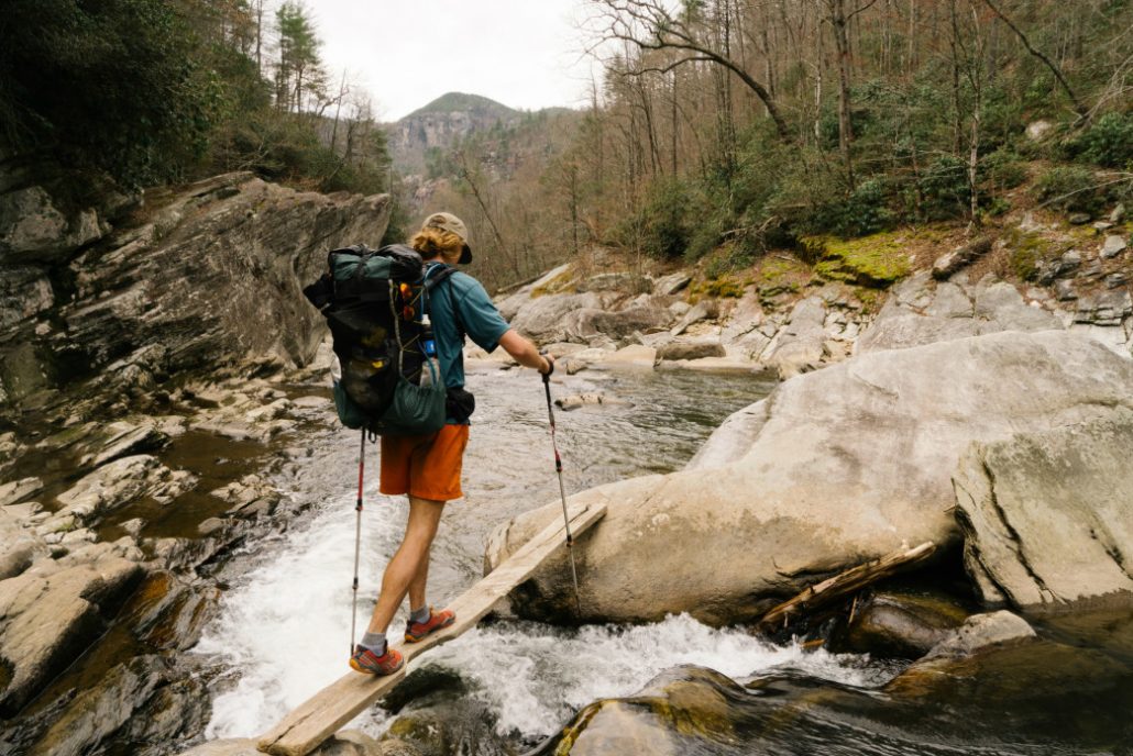
Keep an eye out and cut down into the Linville Gorge Trail by hopping on the Spence Ridge Trail. This will take you down to the river crossing. The bridge has been washed out, but there is rope system to get your bags across the river dryly while you swim. If the river is low, then you may be able to cross by rock hopping like we did.

Photo by Graham Hodge
After crossing the river, follow the Linville Gorge Trail for a long time. You’ll go through sections where the trail is clean and easy as well as rough sections with rock gardens and blown down trees. You may choose to camp along the river after you’ve put in your fair share of miles for the day. The trail is littered with great campsites of all sizes right along the river.
Be prepared for a full day of hiking to end your trip. There is private property in the middle of the Linville Gorge Trail which creates a dead end. To avoid getting to this point and having to backtrack, take the Pinch-In Trail (there will be a sign) to the top of the ridge across the gorge from Shortoff. Once on the top of the ridge follow the road to the Pinnacle Rock Trailhead and follow the trail down to reconnect again with the Mountain To Sea Trail. This will take you all the way down to the river for an epic and typically cold crossing. Once crossing the river, rest up for the steep hike with a 1,800 foot elevation gain with, again, no switchbacks. This will take you all the way back to the intersection that leads to the Wolf Pit Road parking lot. Rejoice in the grueling beauty of the landscape and your recent accomplishment of successfully looping the Linville Gorge.

Photo by Graham Hodge
The Linville Gorge Loop is a serious undertaking for a 3 day backpacking trip. If you are a not an avid backpacker, the loop should be extended to a 4 day trip for maximum enjoyment. A physical map of the area can be found at the Grandfather Ranger District Station. A free permit is required on the weekend from May through October and groups are limited to 10 people. Many people do the loop counter clockwise, just make sure you have enough water for the first 7 miles.
Originally written by RootsRated.
Featured image provided by Graham Hodge


