Posts

The Boone Fork Trail is renowned not only for the sultry beauty of the mountains it passes through, but also the range of ever-changing terrain that one will encounter on this dynamic five-mile loop. The hike begins and ends in Julian Price Memorial Park, a swath of land comprised of 4,200 acres of dense hardwood forest and rolling Appalachian Mountains.

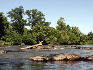
The trail’s namesake river, the Boone Fork, will intersect your path at multiple points along the way, but never with the same temperament. It firsts appears as a flat and docile stream, then transforms over the next few miles into a roaring cascade, tumbling through a garden of cracked granite boulders. As you near the completion of the trail, the river once again becomes placid, cutting through floodplains that, in the summer months, are choked with wildflowers.

Your hike will begin with a gentle climb through soft, undulating hills that give way to cow pastures, meadows, and marshes as the din of the river grows and fades in the background. In the heat of summer, you will be grateful for chilled rhododendron tunnels and tall, shady coniferous trees. The gradient for the majority of the trail is moderate, making it a popular loop for trail runners. A few moments of steep climbing, timber cut steps, and one wooden ladder may present a challenge to children, small dogs, and anyone not dressed for slippery and uneven terrain. Other obstacles include rock hopping, stream crossings, and brief sections of mud.

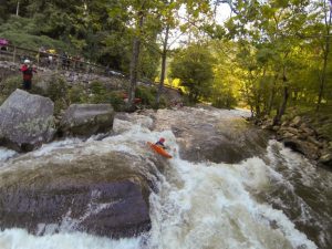
The pinnacle of this hike is Hebron Rock Colony, a jumble of flat-top boulders so thickly dispersed that the river all but disappears beneath them. This unusual feature cuts into the hillside like an ancient highway, providing an idyllic spot for sunbathing and picnicking. In certain areas, water splashes over granite tongues, creating a natural water park that will prove irresistible on sweltering summer days.

Farther along the trail, rock outcrops provide views of iconic Grandfather Mountain and Hanging Rock. Long range mountains views are secondary, however, to the immediate splendor of a lush, river-fed landscape, wide open fields, and waist high wildflowers. Not long after embarking from the parking lot, you will find yourself feeling completely immersed in an ethereal beauty reminiscent of a watercolor painting.

Although swimming spots and sunny meadows make this hike a popular excursion in spring and summer, Boone native Ambrose Park advises paying a visit in the off season as well.

“The Boone Fork trail is awesome, but in the summer you run the risk of crowds,” says Park, warning that on weekends he’s seen people forfeit their hike because they couldn’t find a parking spot. “I like to run it in the fall when there are less people and all the colors, and in the winter the river forms all sorts of enchanting icicles.”

To access the trail, cross the footbridge at the Price Park Picnic Area, mile marker 296.4 in Julian Price Memorial Park. Allow yourself three hours of daylight to complete this hike.

JOIN OUR NEWSLETTER

Featured image provided by Joe Giordano

Intro

Delving into the etymology of Charlie’s Bunion reveals a historical tale of exploration during the earliest days of Great Smoky Mountains National Park. Famed author and adventurer, Horace Kephart, was leading a reconnaissance trip high into the remote Saw-tooth region of the Smokies. This knife-edged ridgeline runs between the Mt. LeConte and Mt. Guyot massifs; its airy undulations are some of the most remote parts of the Park — and a profile view of the 10 mile stretch of peaks resembles the serrated edges of a saw. Warn out from the rigors of exploration Kephart’s companion, Charlie Conner, removed his boots during a break and revealed a set of haggard feet. His mangy extremities resembled the nearby bulging outcropping of rocks known then as Fodderstack. Kephart, one of the Great Smokies’ greatest advocates, proposed renaming the rock Charlie’s Bunion to commemorate his misery.

What Makes It Great

Charlie’s Bunion can be reached by a 4-mile hike on the Appalachian Trail. A picturesque drive to Newfound Gap (sight of the Park’s inauguration) leads to the start of this scenic hike. Forests of fragrant firs line the rocky path and long range views will entertain your eyes as you make your way north on the AT. This particular section of the AT has a total elevation gain of 1,600 feet and climbs to over 6,000 feet on the sides of Mt. Kephart as it leads to the BunionNearly 3 miles into the trail, hikers are offered a reprieve from the rigors of trail life at the Icewater Springs Shelter. Bring a water filtration system and nourishment for a high country hiatus at this “life-list” shelter. Icewater Springs is home to amazing Appalachian views and a perpetually cold water source, making it an ideal resting point on your way to the Bunion.

Four miles into your hike, a signed spur trail on your left will lead you in the direction of Charlie’s Bunion. Explore the area carefully; large drop offs and loose rock here will require your utmost attention. Your reward for reaching the Bunion is paid off in views.The area is walled in by the beautiful behemoths: Mt. Kephart, Mt. Guyot, and Mt. Leconte. An uninterrupted westward view over the sprawling green expanse of Eastern Tenessee opens up on the summit.

Who is Going to Love It

If you’re looking to experience the Appalachian Trail — sans blisters and without walking all the way to Maine — then you will love this 8-mile out-and-back sampling of the world famous trail. Adventurous scramblers will find a playground on the rocks and photographers can capture amazing sunset views from this precipitous peak.

Directions, Parking, & Regulations

From Asheville, an hour and half drive will take you to the Newfound Gap parking lot where you will begin your hike northbound on the AT. Ample parking and restroom facilities are also available at Newfound Gap.

A day hike to the Bunion does not require any permits or fees.

If you wish to stay at the Icewater Springs shelter make reservations in advance. This shelter is quite popular and a permit is $4 per night, per person.

JOIN OUR NEWSLETTER

Featured image provided by Justin Meissen

At Diamond Brand Outdoors, we believe that the outdoors are for everyone — and we love helping our community discover new places to get outdoors. To celebrate the arrival of summer, our local experts have put together a list of their favorite hikes, from easy to challenging. Make this your most active summer yet (and save on some new gear) by taking the Summer Trail Challenge.

Hit six of our 14 favorite trails before September 23  (the first day of autumn), and you’ll get 25% off up to six items.

Just stop by any Diamond Brand Outdoors or Frugal Backpacker location, grab a free sticker, or purchase a logo water bottle, hat, or tee. Take a pic showing off your Diamond Brand Outdoors swag on the trail and post it to Instagram or Facebook with the hashtag #AVLSummerTrail. Make sure to tag @diamondbrand_outdoors or @frugal_backpacker. We would love to see some smiling faces! (Be a good steward and skip any urges to actually stick a sticker on a sign, tree, or anything else that doesn’t naturally have a sticker.)


Easy – Moderate:

Asheville Urban Trail

Crabtree Falls

Craggy Gardens

Glassy Mountain

Hard Times Loop

Lover’s Leap

Max Patch

Mt Pisgah

Pink Beds

Moderate – Difficult:

Black Balsam

Coontree Loop

Devil’s Courthouse

John Rock

Looking Glass

Once you’ve hiked six of the trails, return to any Frugal Backpacker or Diamond Brand Outdoors location to receive your discount. A team member will take a look a look at your tagged photos — which we’d love to share on our feed if you give us permission.

JOIN OUR NEWSLETTER

When you think of “wilderness,” what image pops into your brain? I’d wager a lot of you first thought of snowcapped peaks — or maybe a convoluted canyonland, a lake-pocked boreal forest, or some windswept desert badlands.

All of these places are undoubtedly amazing, and worldwide they certainly account for some of the deepest backcountries left on the planet. But in my mind’s-eye, there aren’t many landscapes that so embody “wild” as a swamp: dark, waterlogged, chirring with insects and frogsong — or, in northern wintry mode, a frozen-over backwater of tussocks, deadfall, and horned owls.

One of America’s foremost wilderness sages, ol’ Henry D. Thoreau, also ranks among the world’s most quotable swamp fans. Should you doubt the healthful stimulus a swamp provides the human spirit, just dip into Henry’s writings. “I enter a swamp as a sacred place — a sanctum sanctorum. There is the strength — the marrow of Nature” (“Walking”). Or, from the same essay: “Yes, though you may think me perverse, if it were proposed to me to dwell in the neighborhood of the most beautiful garden that ever human art contrived, or else of a Dismal Swamp, I should certainly decide for the swamp.”

Here, here!

Though the people often label any old morass a “swamp,” it’s got a specific definition. Very roughly, it’s a wetland dominated by woody vegetation: trees or shrubs. Marshes, by contrast, are more open environments with herbaceous plants such as sedges and cattails. A bog can look rather like a swamp with its stunted timber, but it’s an acidic mire that builds up peat and is usually thick with sphagnum moss.

(You’ll notice the Everglades isn’t on the list below: Though it does contain many small swamps in the form of cypress domes and willow/bay thickets, and though it borders two of the big swamp complexes treated here, the true “Everglades” refers to a wholly unique marsh, not swamp, ecosystem.)

Let’s take a mucky tour of some of the most important swamps in America: some of the biggest, yes, but also much smaller ones still notable for their old-growth character — or for being awesomely intimidating pocket wildernesses in the midst of heavily peopled surroundings.

The Great Dismal Swamp (Virginia/North Carolina)

The iconic Great Dismal Swamp National Wildlife Refuge, home to Lake Drummond, one of only two natural lakes in Virginia.
USFWS

“Never was Rum, that cordial of Life, found more necessary than in this Dirty Place.” That was the cheery endorsement offered of the Great Dismal Swamp in the mid-1700s by Colonel William Byrd III, who named this darkly timbered wetland wilderness that once likely covered a million acres on the Atlantic Coastal Plain of southeastern Virginia and northeastern North Carolina. More than 112,000 acres of the swamp, heavily impacted by logging, draining, and development, constitute the Great Dismal Swamp National Wildlife Refuge, with North Carolina’s Dismal Swamp State Park bordering the southeastern end.

Diminished though it may be, the Great Dismal Swamp — often considered the most northerly of the Southeast’s great bottomland swamps stretching down to Florida — remains one of America’s most evocative wetlands.

Like some Bahamian blue hole, Lake Drummond (the biggest natural lake in Virginia) forms a big watery eye in the middle of the refuge. Its huge baldcypress hulks are reminders of the stature of the old-growth swamp forest that once covered most of the basin. Baldcypress, water tupelo, and Atlantic white-cedar used to dominate the canopy, but red maple covers the most acreage today, having colonized extensive habitat in the wake of logging, fire suppression, and other human modifications. (You’ll find red-maple swamps all the way from Maine to Florida.) Meanwhile, marsh is developing in the extensive scar south of Lake Drummond created by the lightning-sparked Lateral West Fire, which raged for 111 days in 2011.

The Great Swamp (New Jersey)

You can bet Thoreau would appreciate the fact that the sodden groves and rank fern beds of the Great Swamp bristle only 26 miles from Times Square. He would also appreciate the efforts of the local citizens who banded together in 1959 to thwart the conversion of these forested wetlands, marshes, ponds, glades, and hardwood uplands into a jetport proposed by the Port Authority of New York. The 3,000 acres they donated to the U.S. Fish and Wildlife Service became the core of the Great Swamp National Wildlife Refuge, now more than twice that size. The refuge’s eastern half composes a federal wilderness area.

The Great Swamp, which edges Long Hill of the Watchung Mountains to the south, formed thousands of years ago in the emptied basin of Glacial Lake Passaic. The Passaic River and a few of its tributaries, namely Black Brook and Great Brook, drain the swamp to the west.

Get your bearings on the short boardwalk trails at the Wildlife Observation Center in the middle of the refuge or the Great Swamp Outdoor Education Center, then foray into the depths along longer paths penetrating the Great Swamp Wilderness.

The Congaree Bottomlands (South Carolina)

Think all of America’s big trees are on the West Coast? Think again: The floodplain forests and river swamps in Congaree National Park — the largest remaining old-growth bottomland hardwood forest in the Southeast — flings up a truly mighty canopy, one of the loftiest of any deciduous forest in the world. Congaree’s cathedral groves include a 167-foot-tall loblolly pine, a 162-foot-tall swamp tupelo, a 160-foot sweetgum, and numerous other champion trees.

You can tent out in a pair of developed campgrounds or in the backcountry, penetrated by a trail network and paddling routes along Cedar Creek and the Congaree River itself.

The Four Holes Swamp (South Carolina)

South of the Congaree in the Edisto River basin, the Four Holes Swamp includes the country’s largest old-growth stands of baldcypress and water tupelo, the botanical tag-team that dominates so many Southeastern river swamps. Home to the 17,000-plus-acre, National Audubon Society-owned Francis Beidler Forest, this alligator-, cottonmouth, and anole-prowled blackwater swamp—once a sanctuary for the Natchez Indians and, during the Revolutionary War, the “Swamp Fox” Francis Marion—is named for the deep ponds or “holes” sprinkled within it. Some 1,800 acres of the forest are virgin, defined by giant baldcypresses above an under-canopy of tupelo: trees that may be 1,000 years old or more.

The Four Holes Swamp ranks among the most awe-inspiring of America’s wetlands, and you can get a taste for it with a walk on the Audubon sanctuary’s 1.75-mile boardwalk trail or a canoe or kayak safari (reservations required) through the blackwater channels.

The Okefenokee Swamp (Georgia/Florida)

Camping at Floyd's Island during a 3-day canoe trip in the Okefenokee National Wildlife Refuge.
Camping at Floyd’s Island during a 3-day canoe trip in the Okefenokee National Wildlife Refuge.
Timothy J

Shadowy sloughs through Spanish-moss-spangled baldcypress, jungly tree hammocks, waterlily lakes white with blossoms: The Okefenokee may well be the country’s archetypal swamp. Covering some 700 square miles on the Georgia-Florida line, it’s also one of the biggest. Its sandy basin, hemmed on the east by an ancient dune called the Trail Ridge, serves as headwaters for the Suwannee River (flowing to the Gulf of Mexico) and the St. Marys (flowing to the Atlantic). The floating rafts of peat scattered in the so-called “prairies” of the swamp, which ultimately will be colonized by bays and other plants, explain the meaning of Okefenokee: “Land of the Trembling Earth.”

A multiday canoe trip into the Okefenokee National Wildlife Refuge locks you into the slow rhythm of the place. Well, for one thing, it’s slow paddling, given the twisting channels, the often-shallow water, and the obstructions of peat islands and emergent vegetation. You’ll probably see more than one gator hauled up on a log; the sight of a swamp black bear’s a rarer thrill.

The Green Swamp (Florida)

Along the lines of the sharp dichotomy between Manhattan and Jersey’s Great Swamp, the Green Swamp of Central Florida stakes out a reptile-thick wilderness within a stone’s throw or two from Walt Disney World (hacked out of a swamp, mind you). Covering roughly 900 square miles, the swamp — actually a diverse matrix of cypress swamps, riverine and bottomland hardwood forests, hammocks, marshes, and upland woods — is one of the Sunshine State’s major headwaters, giving rise to numerous rivers and daily funneling hundreds of thousands of gallons of water per square mile into the Florida Aquifer, upon which millions of people rely.

Some 110,000 acres of the landscape compose the Green Swamp Wilderness Preserve overseen by the Southwest Florida Water Management District. Hiking opportunities abound, not least on a long segment of the Florida National Scenic Trail.

Southwest Florida Mangrove Swamps

Slacklining during a canoe trip in the Florida Mangrove swamps.
Tristan Loper

The ragged seashore of Southwest Florida is one of the wildest coasts in the country. It’s also one of the greatest swamplands, given it’s dominated by mangrove jungle (aka mangal). Mangrove swamps are massively significant worldwide as nurseries for fish and other marine life as well as stabilizing bulwarks against wave erosion and hurricanes. They’re mostly a tropical feature and therefore rare in the U.S., but the Ten Thousand Islands and the mangal sloughs off the Big Cypress and the Everglades create one of the most significant mangrove mosaics in the Western Hemisphere.

Though the giant bird rookeries of the past have been reduced, the Southwest Florida mangal is still thronged with feathered life—egrets, ibises, cormorants, pelicans—and manatees, dolphins, and tarpon cruise the bays. American crocodiles, meanwhile, find refuge in the mangrove margin of Florida Bay. For experienced boaters, the Wilderness Waterway serves as the classic journey through this magnificent backcountry.

The Big Cypress Swamp (Florida)

The Florida Trail also strikes through the one-of-a-kind wilderness of the Big Cypress Swamp, a vast patchwork of cypress domes and “strand” swamps, pinewoods, palm savannas, and tropical hammocks edging the Everglades to the northwest. The name today is more evocative of the extent of the country (a watershed of more than 2,000 square miles) than the size of the baldcypresses, given the old-growth titans were nearly completely lumbered out. But take a stroll on the boardwalk through the Corkscrew Swamp, a protected pocket of old-growth in the far northern Big Cypress, to get a taste for how utterly massive those buttressed conifers can grow.

The Corkscrew Swamp is an Audubon sanctuary, separated by development from the complicated patchwork of publicly owned lands encompassing most of the remaining Big Cypress Swamp: among them the Fakahatchee Strand State Preserve, the Florida Panther National Wildlife Refuge, and the Big Cypress National Preserve. The latter 720,000-acre parcel, managed by the National Park Service, borders Everglades National Park to the east and south.

Hikers and backpackers in the sprawling Big Cypress National Preserve outback have the chance of glimpsing a Florida black bear or a Florida panther, that puma subspecies now restricted to South Florida, more common here than in the Everglades. And particularly in the winter dry season, waterways are crammed with egrets, anhingas, wood storks, alligators, and other critters.

The Atchafalaya Swamp (Louisiana)

A tour boat rests serenely in Atchafalaya Basin.
Matthew Levine

Encompassing some 900,000 acres of baldcypress-tupelo bayous and bottomland hardwood forests, the Atchafalaya (“Long River” in the indigenous Chitimachas language) Swamp is often called the biggest riverine swamp in the U.S. It hugs most of the Atchafalaya River’s 140-mile corridor extending from just south of the Mississippi-Red River confluence to the vast marshy Atchafalaya Delta on the Gulf of Mexico (its own superlative wetland complex).

Harvested for oil, gas, and timber, long hunted and fished, the Atchafalaya Swamp is also a major haven for wildlife, including the rare Louisiana black bear. The swamp’s intimately tied to the Mississippi River: The Atchafalaya River has long been a flood spillway for the Mississippi, and were it not for Army Corps of Engineers regulating flow, the Mississippi might well abandon its current delta and follow the shorter seabound course through the Atchafalaya.

Heavily impacted by humanity, the Atchafalaya is nonetheless big and wild enough to give a major sense of swamp primeval. The Atchafalaya National Wildlife Refuge makes a good jumping-off point.

The Honey Island Swamp (Louisiana/Mississippi)

The 70,000-acre Honey Island Swamp in southeastern Louisiana and southwestern Mississippi’s Pearl River Basin sums up much of the allure of America’s swamplands. For one thing, it’s one of the wildest and most tucked-away: a remote corridor of hardwood and baldcypress/tupelo swamp in the bottoms between the West Pearl and Pearl rivers, grading into marshlands fronting the Gulf lagoon of Lake Borgne. And for another, like swamps around the world, it’s drenched in lore as an outlaw hideout. Pirates such as Pierre Ramueau, the “King of Honey Island,” used it, as did James Copeland’s notorious gang — and as a sanctuary for a mysterious beast: the Honey Island Swamp Monster.

A good chunk of the Honey Island Swamp falls within the Pearl River Wildlife Management Area. Numerous outfitters run tours through the backwaters, or you can brave the resident “swamp thing” on your own self-guided trek.

The Alakai Plateau (Hawaii)

U8QokcrZ0AGwkc2eIui8
Boardwalks stretching into the eerie Alakai “swamp.”
Marvin Bravenboer

OK, OK, so technically this waterlogged highland in the heart of Kauai isn’t a swamp, even though its popular name is the “Alakai Swamp” and Native Hawaiians also called it the “swamp in the clouds.” Ecologically speaking it’s a unique high-elevation cloud forest strung with many bogs, west of the high rim of Wai’ale’ale. With 460-odd inches of rain a year, it’s one of the wettest places on Earth. Perpetually soaked, it’s the island’s signal fountainhead; much of the voluminous Alakai water ultimately drains through the Waimea River, which carves the awesome Waimea Canyon to the southwest of the plateau.

Atmospherically, the Alakai is pretty damn swamplike in a more colloquial sense: It’s like a high swamp-jungle, usually cloaked in rain and rolling mist, tangled with stunted trees (ohia, lapalapa, and others) and huge ferns, broken by etheral mires and gushing ravines. Walled on three sides by sheer pali (cliffs) and almost impenetrable off the few ancient (and often crazy-muddy) trails that enter it—stories abound of bushwhackers lost for days or plumb vanished—it’s gloriously hard to explore. You can get a taste of it, though, along the Pihea and Alakai Swamp trails beginning in Kokee State Park.

JOIN OUR NEWSLETTER

Featured image provided by USFWS

Imagine unloading your kayak or canoe and setting up camp on an island in the middle of a mountain lake. A brilliant Carolina sunset reflects on crystal clear water as you finish tying off your hammock. Or maybe you’ve reached a coastal oasis accessible only by your own paddle power. At night, you fall asleep in your tent to the relaxing sound of waves.

From the cool waters of Lake Jocassee to the brackish tidal swamps out east, the Carolinas are home to a huge variety of flat water paddling experiences. While many are accessible by day trip, some require a little more time. Here are seven of the best paddle-in campground adventures from the mountains to coast in the Carolinas. Start your adventure with a visit to the paddling experts at Diamond Brand Outdoors.

Cheraw State Park

Several trails offer an on-land option to explore Cheraw State Park.
South Carolina State Parks

Paddling through the cypress wetlands of Lake Juniper is an experience every flatwater boater should have, and at Cheraw State Park the experience couldn’t be easier. The $21 per night camping fee for the paddle-in sites comes complete with boat rental and the park even participates in a fishing tackle loaner program. All you need is your standard camping gear. If possible, time your trip during one of the park’s moonlight paddle outings and see the lake in a whole new light.

Devils Fork State Park

The crystal clear waters and minimally developed shoreline of Lake Jocassee have become a popular retreat in all seasons. Leave it all behind and paddle out to the seclusion of an island campground at Devils Fork State Park. Thirteen sites line the western edge of the island, providing an incredible sunset experience. Basic toilets are available but you’ll need to bring all the other comforts of camping with you — which is a small price to pay for such serenity.

Keowee-Toxaway State Park

Paddle-in campsites at Lake Keowee-Toxaway State Park offer amazing sunset views. Rob Glover
Paddle-in campsites at Lake Keowee-Toxaway State Park offer amazing sunset views.
Rob Glover

Lake Keowee is an oft overlooked gem in South Carolina. Just a few miles from its larger cousin Lake Jocassee, the gorgeous surrounds and cool, calm waters of Keowee offer an amazing respite after a long work week. All the sites at the small and quiet campground of Keowee-Toxaway State Park are a pleasant stroll from the lake, but three sit right on the shoreline. You can walk to these sites, but the two-ish mile trek can create a logistics problem when toting all the trappings of a great camping weekend. Instead, load up your canoe and paddle to the site just short distance away from the park’s boat launch.

Hammocks Beach

Tucked between huge dunes, Hammocks Beach State Park’s paddle-in campground feels both hidden and open to the entire universe.
North Carolina State Parks

Reaching the row of waterfront campsites on Bear Island requires first paddle across the intercoastal waterway and through the reedy waters of a coastal swamp. What awaits is a pristine, white sand beach buffeted by large dunes and an unfettered view of ocean and sky. Hammocks Beach State Park, which encompasses Bear Island, offers a convenient launch site as well as boat rentals. The campground is rugged but includes showers and bathroom facilities.

Lake James

Perhaps known more for its super flowy singletrack or uber popular lakeside picnic facilities, Lake James State Park is also home to 30 boat-in campsites. These simple sites include only the basics: fire ring, tent pad, and picnic table. While you’ll have to bring in everything you need, including your water supply, a sunrise paddle on the tree-lined lake is well worth the effort. The closest launch to these sites is at the main visitor center in the Paddy’s Creek section of the park. Here they rent kayaks, canoes, and paddleboards — but they go fast. Call ahead to check for availability or bring your own.

Merchants Millpond State Park

Weaving through immense cypress trees at Merchants Millpond is an experience every paddler should have.
North Carolina State Parks

Designated paddle trails in Merchants Millpond State Park flow alongside dense hardwood forests and through stands of immense bald cypress trees. Just beyond the millpond, Bennett’s Creek runs slow and shallow through the low-lying Lassiter Swamp. A water-level exploration of these fascinating biomes is best begun from one of the state park’s paddle-in campsites. The sites are primitive, with only pit toilets available, but the park does offer canoe rentals.

New River State Park

Not only is the ironically named New River one of the oldest in the world, it is among the most natural and interesting to explore. In recognition of these properties, the New, which runs through the Blue Ridge Mountains in the northwest corner of North Carolina, is a federally designated Wild and Scenic River. A multi-day exploration of this tree-lined waterway can be done Deliverance-style (minus the, well, you know) by way of multiple canoe-in campsites managed by New River State Park. The paddle trip to these primitive campsites is a serene and scenic experience. Although the flow is calm here, it’s important to either know the river; less experienced paddlers should contact Ashe County for a list of local river guides.

JOIN OUR NEWSLETTER

Featured image provided by North Carolina State Parks

The Nantahala River is ideally set up for intermediate paddlers. It has myriad small surf waves, forgiving eddy lines, and rapids with just enough power to challenge and entertain. There is also the capability to set up elite slalom courses through Nantahala Falls and the playhole near NOC has been tweaked through the years, hosting the Freestyle Kayaking World Championships in 2013. Combine those resources with the class IV-V options upstream and it’s easy to see why this area continues to be such a strong paddling destination.

What Makes It Great

Sections

Cascades | 0.7 miles | Class IV-V 

The Cascades are a very high quality and easily-lapped series of drops. The river channels well, allowing for a wide range of runnable flows (and some big holes at high water). Since this is a dewatered section of the Nantahala River, the Cascades run only when Whiteoak Creek is high from rain or during one of a few scheduled releases per year.

Upper Nantahala | 3.1 miles | Class III+ 

This is a scenic and busy section of river that provides a great cool down from the Cascades upstream or a way for aspiring advanced paddlers to get accustomed to more continuous whitewater. The entire section is road-scoutable, so watch out for wood. As far as flows go, the same thing applies as the Cascades. There needs to be rain or a scheduled release.

Nantahala Gorge | 7.5 miles | Class II-III 

The gorge section is also road-scoutable from nearly top to bottom and provides a beautiful and stress-free way to get into the world of whitewater. Notable rapids include Patton’s Run (right off the bat), Delebar’s Rock, Whirlpool, Quarry, Surfing Rapid, The Bump, and Nantahala Falls. The Falls represents an intimidating class III benchmark for many intermediate paddlers and the rocks are always lined with photographers and throwbags on a summer day.

Unique Experiences

Jump Rock 

About 5.5 miles into the run, you’ll see a very obvious large rock on the right (about 10 feet out of the water). It’s a great pit stop to jump or launch boats off of into the invigorating water.

SUP Surfing 

There are several great SUP surf waves on the Nantahala. The two best include one directly below the pedestrian bridge on NOC’s campus and another about two miles upstream at Surfer’s Rapid.

Eat at River’s End 

This restaurant is right next to the takeout and provides a nice après atmosphere to grab food and reflect on the day.

Directions, Parking, & Regulations

Access

Gorge Takeout

Nantahala Outdoor Center
13077 W. Hwy 19, Bryson City, NC 28713 

Gorge Put In 

Drive upstream on Hwy 19 ~7 miles
Turn L onto SR 1442/Wayah Rd.
Large USFS paved lot on left.

Upper Takeout 

Drive upstream on Hwy 19 ~7 miles
Turn L onto SR 1442/Wayah Rd.
Large USFS paved lot on left.

Upper Put In 

Continue on SR 1442/Wayah Rd. upstream for 3.3 miles.
Park at the 5th Bridge (if you hit Cascades, you’ve gone too far).

Cascades Takeout 

Continue on SR 1442/Wayah Rd. upstream for 3.3 miles.
Park at the 5th Bridge (if you hit Cascades, you’ve gone too far).

Cascades Put In

Continue on SR 1442/Wayah Rd. upstream for <1 mile.
You will see all of the drops; park at the top of the action (if you hit Whiteoak Creek, you’ve gone too far).

Important Info

JOIN OUR NEWSLETTER

Featured image provided by Malcolm Smith

Image for Nantahala River White Water Paddling

The Green River is a place that has had a large influence on the world of whitewater paddling and on many boaters’ lives. It is a highly convenient run because of its proximity to Asheville, Greenville, Charlotte, and Atlanta. Since it is a dam-released river, it also runs 300+ days a year.

Add the fact it has three sections of varying difficulties (and one of the most famous and prestigious extreme races) and you start to see why it is beloved by so many. But the truly beautiful thing about the Green is the combination of all these conveniences with an authentic wilderness experience. As soon as paddlers slip into her waters, the Green has a way of softening the sharp corners in life, and re-centering the soul.

What Makes It Great

Upper Section:

The Upper Green is a fantastic run for the class III paddler who is looking to dip her or his toes in the realm of vertical drops. Paddlers are treated to several miles of nice winding class II and III rapids and two borderline class IV drops. Notable named rapids are Bayless Boof, Wanda’s Hole, and Pinball. Take out just before Big Hungry Creek enters on the left and hike the half mile uphill to civilization.

Narrows Section:

The Narrows is arguably the most famous steep creek in the world. With a nice combination of boulder garden and bedrock rapids, this section will challenge and push the most elite of kayakers, but is also accessible (with a few portages) to the class IV+ boater. Go Left and Die, Gorilla, and Sunshine are the three major class V rapids, and there are many more drops that aren’t to be trifled with. The majority of the gradient is concentrated within the “monster mile,” which drops at a rate of 300+ feet per mile. This section lends itself well to multi-lap days.

Lower Section:

The Lower Green is the perfect beginner run. The truly bipolar river lets go of its furious descent and meanders out into a beautiful rural valley. This is a perfect section for the beginner paddler or a summer tube trip. It is completely roadside, so choose how much of the 7 miles you’d like to bite off.

Unique Experiences

Dawn Patrol:

Set shuttle in the dark and put on at first light for an unforgettable experience or great start to the work day!

Heron Viewing:

There are several Great Blue Herons that enjoy fishing the Green. On lucky days, you can quietly follow them down the river as they fly from one fishing spot to another.

Racing:

The Green Race is an experience unlike any other. For those with the skills, paddling down that incredibly challenging course and into a 1,000+ spectator amphitheater at Gorilla is something that belongs on the bucket list. This event always occurs the first Saturday in November. The Narrows get much more intense during the weeks before the race, and this is not a good time for a first-time paddler.

Disclaimer:

Please paddle within your abilities. Paddlers who step above their abilities are very easy to spot and actually endanger river access for all.

Directions, Parking, & Regulations

Access Directions:

  • Upper Takeout: From Asheville, take Interstate 26 East to Exit 22 (Hendersonville/Upward Rd). Take a left onto Upward Rd and drive 1.5 Miles and follow Big Hungry Road to Gallimore Road. Park in gated lot (see below for key info).
  • Upper Put In: From Gallimore Road/Upper Takeout, return to Interstate 26 to Exit 23 (Greenville/225/176/25). Drive 1.8 miles to Exit 176 (Saluda/East Flat Rock), turn left onto 176 and drive 2 miles. Make a left onto Pot Shoals Road. Park on the downstream side of Pot Shoals Bridge.
  • Narrows Takeout: From Asheville, take Interstate 26 East to Exit 59 (Saluda). Make a left off the ramp onto Green River Cove Road. Fishtop Access is a large gravel lot at the bottom of the hill.
  • Narrows Put In: From Asheville, take Interstate 26 East to Exit 22 (Hendersonville/Upward Rd). Take a left onto Upward Rd and drive 1.5 Miles and follow Big Hungry Road to Gallimore Road. Park in gated lot (see below for key info).
  • Lower Takeout: From Asheville, take Interstate 26 East to Exit 59 (Saluda). Take a left off the ramp onto Green River Cove Road. Note the Fishtop Access gravel lot on left at the bottom of the hill. Drive an additional 6 miles to theBig Rock Take-Out gravel lot on left.
  • Lower Put In: From Asheville, take Interstate 26 East to Exit 59 (Saluda). Make a left off the ramp onto Green River Cove Road. Fishtop Access is a large gravel lot at the bottom of the hill.

Important Info:

  • River Gauge: A few rapids below the Narrows put in, you will find a stick gauge. A good minimum on this gauge is 6″. A healthy 100% flow is 9″ and 17″ is 200%. Paddlers have ventured into the Narrows at up to around 36 inches, but the consequence factor becomes exponentially larger as the water goes up. Also, please note that there is no alcohol within 50 feet of the river.
  • Water Schedule: Since this is a dam-released river, it’s important to understand water schedules. 
    • Water to Upper Takeout/Narrows Putin (2.5 hours)
    • Water to Narrows Takeout/Lower Putin (4.25 hours)
    • Water to Lower Takeout (6.5 hours)
    • Water empties faster than it fills. Don’t put in at the Narrows more than 1.25 hours after the dam shuts off.

JOIN OUR NEWSLETTER

Featured image provided by Melina Coogan

Image for Green River

The French Broad Paddle Trail is a series of campsites along the French Broad River connecting over 140 miles of river. It was created by MountainTrue, a non-profit in Western North Carolina that houses the French Broad Riverkeeper, who works to protect and promote the quality of the French Broad River and its tributaries. The paddle trail begins in Rosman, NC, taking paddlers over flat and whitewater. It passes through an incredibly beautiful geographical region of the Southeast.

What Makes It Great

The Cherokee used to call it the “Long Man,” and its tributaries, “Chattering Children.” Later, European settlers deemed it the “French Broad.” The world’s third oldest river has a majestic and ancient appeal. Flat water and whitewater paddlers alike will love the adventure the French Broad Paddle Trail provides. You can now paddle over 140 miles of the river from Rosman in North Carolina to Douglas Lake in Tennessee, staying at campsites all along the way.

The river begins in an area of rolling, shaded farmland, where the North and West Forks come together. As the river plunges through Pisgah and Cherokee National Forests, it eventually opens up to reveal mountains rising out of the water’s edge. The river is perfect for all skill levels, with the first 75 miles consisting of mainly flat water paddling and the rest offering a mix of class I, II, and III rapids. You can easily spend one night or even several weeks exploring one of the world’s oldest rivers.

Starting in Rosman, the French Broad runs northwest through the funky and quaint Western North Carolinian towns of Brevard, Asheville, Woodfin. Weaverville, Marshall, and Hot Springs, as well as Del Rio and Newport in Tennessee. What’s great about this part of the country is the small town feel with an eclectic charm of mountain culture.

Who is Going to Love It

History and nature buffs. Some sections of the French Broad River make you feel like you’re in a prehistoric time. Other times, you’ll see a bald eagle and feel like singing the Star Spangled Banner. Still other times, you’ll float through a town and wonder how that place has been shaped by the river…and vice versa.

Directions, Parking, & Regulations

Visit French Broad River Paddle’s website for all your logistical needs. At the website you can make a reservation, look at a map, find access points, or read about the campsites. Campsites are $25/night, with no limit on the number of your entourage. Plan your trip ahead of time and know your river. There are three dams on the French Broad, and we discourage portaging all of them. These portages are very time-consuming and oftentimes dangerous. Try to plan your trip where you take out before these dams. Local Asheville outfitters Diamond Brand Outdoors and Frugal Backpacker.

The French Broad Paddle Trail is open 365 days a year. Campsites are strategically placed, so that paddlers can reach their sites within a single day. The longest distance between sites is 15 miles. The campsites are paddle-in only, meaning you’ll be far away from car-camping glampers. Remember these campsites are paddle-in sites, so don’t leave a bunch of litter after your stay. It makes it very difficult for volunteers and French Broad River Paddle employees to clean up when they’re already carrying lawn mowers and weed-eaters to do maintenance. So, practice leave-no-trace principles wherever you go, and have a great paddle.

JOIN OUR NEWSLETTER

Featured image provided by anoldent

Primarily a popular whitewater rafting destination, the Pigeon River is a dam controlled river that winds its way through North Carolina and Eastern Tennessee before emptying into the French Broad River.

What Makes It Great

Situated along the Smoky Mountains, the Pigeon River provides beautiful views as you make your way. Paddlers along the Upper Pigeon will brag about the famous whitewater encountered — Roller Coaster, Powerhouse, Lost Guide, and many more that will keep your energy high and your skills tested. The Lower Pigeon provides a much better experience for the paddler wanting to become more comfortable with intermediate whitewater, with many calm sections and rapids from class II/III.The Pigeon River has impressively overcome quite a bit of environmental damage over the last two decades. It used to be an extremely polluted waterway with rapidly decreasing biodiversity, but now it has healthy fish populations (which anglers take advantage of) and a growing recreational presence.

Who is Going to Love It

For thrill seekers and more experience paddlers, you’ll want to choose the Upper section of the Pigeon because it has a lot of fun play spots and about five miles of Class II-III+ rapids. For novice paddlers or those simply looking to soak up the scenery, the Lower section of the Pigeon provides four miles of family friendly flat water where swimming is encouraged.

Directions, Parking, & Regulations

Public access along the river is primarily limited to bridge crossings and small pull-offs along the roads paralleling the river. There are a few primitive launching areas for canoes and other small boats.For the Upper Pigeon- Parking can be found by taking I-40 to exit 451, taking the bridge and turning up river. Take Waterville Road and you will see a parking area/put it. More information can be found here. For the Lower Pigeon, head towards Hartford, and park at any of the put-ins near the rafting outfitters.

JOIN OUR NEWSLETTER

Featured image provided by Jared

The waters of Yellowstone Prong spring from the peaks of the Great Balsam Mountains and gather themselves in Graveyard Fields. Born from springs above 6,000 feet and purified through the 5,000 foot meadow, these waters run crisp and clean. The perpetually cool waters flow peacefully through the hanging valley before plunging down a raucous ravine which leads to the Prong’s confluence with the East Fork of the Pigeon River.

What Makes It Great

From the mouth of Graveyard Fields the Yellowstone Prong cascades over the mighty Second Falls and then the secluded Yellowstone Falls. A short distance downstream the Prong makes its most risqué drop over Skinny Dip Falls. At this popular swimming hole a series of cascades and plunge pools line the banks of a heavenly ravine. A short, half-mile walk from the Blue Ridge Parkway, leads to Skinny Dip falls where you can cool your body and refresh your soul in the wild waters of Appalachia.

Access to Skinny Dip Falls can be found right off the Parkway from the Looking Glass Rock overlook. Across the Parkway, from the overlook, a blazed spur trail leads into the woods. After taking this trail and entering the woods you will notice a “trail tree,” which was formed as a trail marker by indigenous tribes. Perhaps they also enjoyed taking a dip, skinny style, in the Yellowstone Prong? After passing the ornate tree – some say the face of a dragon can be seen in its gnarled bark – hikers will come to an intersection with the Mountains-To-Sea Trail. Veer left at this intersection and follow the rocky trail until reaching the swimming area. When you reach a wooden staircase leading to a bridge spanning the creek, you have arrived!

Enjoy the series of plunge pools, but please keep your clothing on if there’s a crowd. The falls are Skinny Dip by name only, not by nature during busy hours. A grouping of Boulders along the right side of the upper pool provides a platform to jump into the 6’ deep water. Use caution and make sure to hit your mark if you decide to take the leap off of the 8’-10’ rocks. The lower pools of Skinny Dip Falls are serenely beautiful and offer wading and lounging opportunities on their sun-soaked rocks.

Who is Going to Love It

Thanks to such easy access Skinny Dip Falls has become a highly popular area for families and adventurers. On warm summer days you are likely to share the water with a crowd. Fear not though, there are plenty of pools to spread the watery wealth. This swimming hole is in the vicinity of some incredible hiking trails. The Art Loeb, Mountains-to-Sea Trail, Black Balsam Knob, and Shining Rock are all within striking distance. Take a hike, then cap off your adventurous day by soothing your aching muscles in the waters of Skinny Dip Falls!

Directions, Parking, & Regulations

From Asheville, catch the Blue Ridge Parkway. Head south on the Parkway towards the Looking Glass Rock Overlook, located by mile marker 417. Parking here is free but you may want to get there early on pretty summer days to find a spot. Dogs are welcomed, but should be kept on a leash until they are ready for a swim.

JOIN OUR NEWSLETTER

Featured image provided by Jenn Deane

Events

Nothing Found

Sorry, no posts matched your criteria