Posts

Nepali food is a dynamic mixture of cuisines from all over the world, as complex as the people who make up this wonderful and mysterious country. To better understand the food, we will first have to take a look at the people. Nepal is a landlocked central Himalayan country in South Asia with an approximate population of 26.7 million people. Nepal is bordered by India on three sides and China to the north. The citizens of Nepal are known as Nepali or Nepalese. Generally speaking, Nepalis do not equate their nationality with ethnicity, but with citizenship and allegiance.

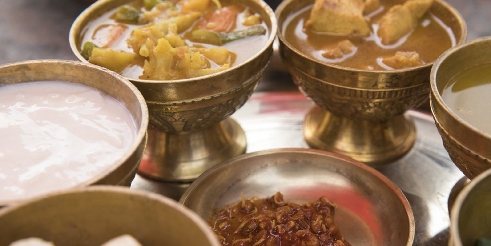
Ordering Thali is a great way to try several curries, spices and flavors on one plate.

One of the most famous Nepali dishes is the Momo. From the Chinese pot sticker, to the Japanese gyoza and Taiwanese soup dumpling, it seems each Asian country has their version of this tasty and popular snack. It can be made with a wide variety of different fillings. Meats commonly used are pork, chicken, goat and even water buffalo. As with most dished in Nepal, a vegetarian options is almost always available and is generally made from chopped vegetables. Momos can be steamed or fried and are served with a dipping sauce, which is usually tomato based and a little spicy. You’ll find these tasty treats in the homes of the Nepali people, and at just about every restaurant you come by.

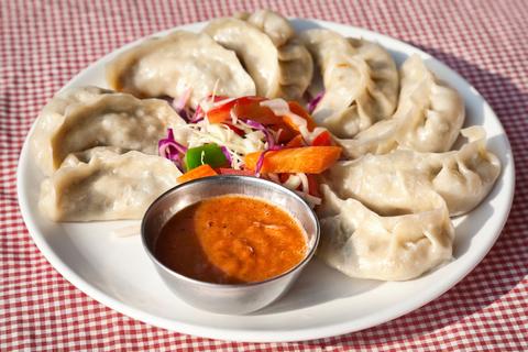
Nepalese traditional dumpling momos served with tomato chatni and fresh salad in restaurant

Another popular meal in Nepal is called Thali. However, Thali by name simply means plate. Thali is an Indian style meal made up of several dishes served on a platter, many times this is on a beautiful brass platter. Nepalese Thali can consist of Dal (a soup made of lentils and spices), rice, pickles – the variety of Nepali pickles is said to be in the thousands, and a curry (can be mutton, chicken or vegetable and is much lighter than it’s Indian counterpart). The traditional way of eating Thali is with your hand (right hand only, please!). Many restaurants serve their own variation of Thali – generally with a vegetarian and meat option.

Nepali food is surprisingly lighter than the food of its neighbor, India, but retains all of the flavor. Gone are the heavy cream sauces and most dairy in general. The robust spices and fiery chilis remain. Nepali food is an instant favorite for those looking for a fun change of pace.

JOIN OUR NEWSLETTER

Intro

When we take the time to relax beside the roaring waters of an Appalachian stream, something incredible happens to our psyche. The roaring thunder of the water drowns out all the worries and doubts you carried from “real life.” The continual flow of a mountain stream ignites an innate sense of oneness with our surroundings and reminds us that time marches on.

What Makes It Great

On the Northern edge of the Great Smoky Mountains National Park, a stream rambles in perpetuity from the balsam covered mountains above until reaching its confluence with the mighty Pigeon River below. The headwaters of this stream are born from some of the highest peaks in the park: Mt. Sterling, Big Cataloochee and Mt. Guyot. As the tributary waters rush down these steep slopes, they are purified by the lush flora of the Smokies before combining their efforts into what is known as Big Creek.

The Big Creek Campground is peacefully located right beside the cool, rushing waters of Big Creek. A total of 12 spots are available on a first-come, first-served basis. The campground has easily-accessible and well-maintained restrooms that also provide drinking water. All of the sites at Big Creek Campground are considered walk-in, meaning you will have to leave your car in the parking lot and walk a short distance to a tent-only campsite. Each site is conveniently outfitted with a leveled tent pad, charcoal grill, and picnic table. The sites are strikingly beautiful and surprisingly serene considering Big Creek’s popularity.

The true beauty of the Big Creek Campground lies in its location. From the campground parking lot, visitors have easy access to one of the area’s most popular swimming destinations, Midnight Hole, via a 1.5-mile hike up the gently graded Big Creek Trail. Baxter Creek Trail also starts from the parking area and leads to stunning views from the fire tower atop Mt.Sterling. Also within striking distance from the campground is the Chestnut Branch Trail which climbs to the famous lookout tower atop Mt. Cammerer. The bold can take their kayaks down Big Creek and families can enjoy a guided rafting trip on the nearby Pigeon River.

Who is Going to Love It

Adventurers love the location of Big Creek’s Campground for its access to hiking, fishing, and flowing whitewater. However, you don’t have to embark on an epic adventure to enjoy the serenity of this area. Families love the placid picnic settings and creekside accommodations the campground has to offer.

Directions, Parking, & Regulations

To reach the Big Creek Campground from Asheville, travel west on Interstate 40 to the North Carolina/Tennessee state line and take the exit 451 for Waterville. Take a left and cross over the Pigeon River via a bridge shared by the Appalachian Trail. Continue on this road until you reach a four-way stop. Go straight through this intersection and follow the signs for Big Creek Campground. Big Creek Ranger Station is located a quarter of a mile past this intersection on the right. Stop here to get more information on the area and a detailed map for a requested $1 donation.

Continue up the road for 1 mile until you reach the parking lot for the Big Creek Campground.

The Campground is open May-October and sites are $14 per night.

Featured image provided by Patrick Mueller

Intro

The Appalachian Trail follows the crest of the Appalachians along the North Carolina and Tennessee state line. In between the soaring mountains of the Great Smokies and the rolling hills of Hot Springs, the AT passes over the grassy bald known as Max Patch. The man-made meadow on top of the mountain was once home to large herds of grazing cattle. Today, the luscious green summit is home to one of the most acclaimed view-points in the Southeast and the herds have switched from bovine beasts to outdoor enthusiasts. A variety of trails can be used to access Max Patch. The most popular and pedestrian of the choices leads hikers to the grassy summit on a short, half -mile climb to the top.

What Makes It Great

At 4,600 feet, Max Patch is not a particularly high mountain, yet the views from the top are highly acclaimed. The view’s infamy comes from its grass covered summit stage, which offers long range views in every direction. The view is framed to the southwest by the northern giants of the National Park: Mt. Guyot, Mt. Sterling and Big Cataloochee. The Plott and Great Balsam Ranges paint the southeastern skyline while the towering crest of the Black Mountains stands guard to the east and the Roans to the north. The Patch is surrounded by picturesque rolling hills and mountains leading up to these mighty ridge lines in three directions. To the west, however, an uninterrupted view over the lush expanse of Tennessee allows for a famously stunning sunset view.

Several trail options line the sides and summit of Max Path. From the parking lot, visitors can take the direct route to the summit for a 1-mile round trip or the 2.4 miles loop which circumnavigates The PatchThose looking for a prolonged jaunt through the woods can follow the AT north or south as far as their hearts desire.

Who is Going to Love It

Photographers will find life-list photo opportunities atop Max Patch thanks to its ideal location on the western edge of the Appalachians. Bring your tripod along and set up for spectacular stellar and sunset shots. (Looking for more photogenic landscapes?) Romantics can take full advantage of Max Patch’s beauty by packing a blanket and picnic lunch to the easy access summit. Cap off your romantic evening as you return towards Asheville by taking a dip in the dreamy waters of nearby Hot Springs Resort. Anglers, bring your gear and cast a line in the Forest Service pond just past the parking area. The brave even venture to The Patch in winter for skiing and sledding amongst the sublime scenery.

Directions, Parking, & Regulations

A trio of route options leads to Max Patch from Asheville. If you choose to tackle these routes in winter, come prepared with an emergency kit and snow-worthy vehicle. There is no access fee for the trailhead. Camping is allowed in nearby areas, but is prohibited on the summit itself. Venture just past the summit for the prime locations. Bring your fury friend along for this outing: the area is dog friendly and they will thoroughly enjoy the grassy summit!

Featured image provided by Jake Wheeler

The Asheville Outdoor Show makes its annual appearance on September 17 from noon to 4:00 p.m. at Salvage Station. Since we’re at a new spot, we figured you might have some questions. We’ve got answers.

Location

Salvage Station is located at 466 Riverside Drive in Asheville’s River Arts District, in between Downtown and West Asheville.

Parking

There is limited parking at Salvage Station. PLEASE plan to carpool, bike, walk, or take an Uber or Lyft.

Who To Expect

We’ve invited a mix of local gear makers, national innovators, and nonprofit organizations. Check out the full list!

Family Friendly

Bring the kids to the KEEN Family Adventure Zone for face painting, sidewalk chalk, and Camp Cedar Cliff‘s AH-MAZIN’ Climbing Wall.

Giveaways + Raffle

The first 1,000 folks through the door will receive exclusive discounts at Diamond Brand Outdoors and Frugal Backpacker including a $10 gear card to each store! Other booths will have stickers, keychains, and other fine schwag to collect. Everyone will have a shot at winning a handsome reward in the form of our raffle packages.

Contests

Stop by the Asheville Trails and Trailful tents for your shot at taking the top spot in a contest to pack a backpack the quickest. Marmot will also have contests that test your speed when it comes to pitching a tent and getting in and out of a sleeping bag.

Food and Drink

The venue has a full menu featuring eclectic Southern and Appalachian inspired choices and food trucks, as well as a full bar. Outside food and drink is not allowed.

Music

Local legends The Blue Dragons will be bringing positive vibes to the Osprey Outdoor Stage throughout the day.

Yoga

prAna is hosting 20-minute riverside yoga sessions at 12:30, 1:30, 2:30, and 3:30. Just bring your own mat!

Pets

From Salvage Station’s website: “Service animals only. We have a large number of natural wildlife animals around our site that we are trying to be respectful of in the coming years. Also, we plan to have several high volume events that would not be conducive to having large groups of animals here. We apologize for the inconvenience in advance.”

JOIN OUR NEWSLETTER

A voluminous network of trails spiderweb the mountains that surround Asheville. Soaring ridge lines, breathtaking views, and an epic array of terrain have long established this city as one of the hiking epicenters of the country.

The tireless efforts of such organization as  The Carolina Mountain Land Conservancy and the Conservation Trust for North Carolina have not only protected the existing state parks and forests, but have been able to expand upon them by thousands of acres. From the heights of Mount Mitchell, the tallest peak on the East Coast, to the waterfall-studded trails of Dupont, to the sublime views of Max Patch, the outdoor opportunities in the Southern Appalachians are limitless.

Mount Mitchell

Robert Aberegg

Hikers, backpackers, trail runners, and naturalists flock to the summit of Mount Mitchell not only for the beauty of its surroundings, but also because it is the highest peak East of the Mississippi. Towering above the Black Mountains, the views from the top are truly exceptional.

One of the best ways to reach this acclaimed summit is to begin at Black Mountain Campground on the South Toe River in Burnsville. The steep, thickly wooded trail climbs 3,600 feet in just over 5.5 miles. The forest transforms as you quickly gain elevation, a welcome distraction to the grueling uphill hike. When you reach an alpine meadow abloom with wildflowers, allow yourself a well deserved break, as the rigorous pace of the trail soon picks up again. Even experienced hikers will find this a strenuous, all day excursion, but the the reward of heavenly views and pristine mountain air at the summit are worth the effort.

When you arrive, take a moment to pay tribute to Elisha Mitchell, for whom the mountain was named. This scientist, explorer, and professor was the first person to measure the mountain and declare it the highest in the East. She is buried on the summit.

Shining Rock

Daniel Meacham

Luminous with bright white quartzite rock, the summit of Shining Rock is a veritable gem of the Appalachians. In the Shining Rock Wilderness, high in the Great Balsam Mountains, miles of soaring ridgeline string together grassy balds laced with wildflowers and surrounded by ethereal views. Perched high in the rugged and remote wilderness, the quartzite garden atop the summit is a popular spot for star gazing.

Although a collection of trails leads to Shining Rock, the most picturesque of these includes a section of the Art Loeb Trail. Park at Black Balsam Knob Trailhead on Road 816 off of the Blue Ridge Parkway; head North and follow the white blazes of the Art Loeb Trail. You will reach the top of rounded summits, traverse five miles of spectacular ridgeline, and drop down mountain passes before reaching Shining Rock Gap. From there, scramble up a network of unmarked trails to the summit and watch the sunlight bounce off crystalline rock formations.

Dogs are more than welcome, and no fees or permits are required to hike or camp at Shining Rock. However, it is a designated Wilderness Area, so be aware of the specific guidelines that come along with that.  

DuPont State Forest

Mark Stoffan

In 2012, DuPont State Forest gained notoriety as the hauntingly beautiful backdrop of the smash blockbuster hit The Hunger Games. Before then, this 10,000 acres of wooded wilderness was best known for its abundance of waterfalls. The Little River cascades through the forest, careening over Bridal Veil Falls, Triple Falls, High Falls, and more. Eighty miles of meandering, multi-use trails and five cold water mountain lakes makes DuPont a hiker’s oasis during the hot summer months.

For a mellow and scenic excursion, check out the 4.5 mile trail leading up to Cedar Rock. It awards sweeping views without much elevation gain. If you’re up for something a bit more strenuous, both routes to the top of Stone Mountain, the highest point in DuPont, are steep and demanding, but offer gorgeous and far reaching views (and a lot less people than the popular waterfall trails). At the end of the day, take a dip in the expansive, 99 acre Lake Julia.

Linville Gorge Wilderness

Weekend trip to Linville Gorge & Grandfather Mountain
Michael Sprague

The 12,000 acres of the Linville Gorge Wilderness Area are some of the most rugged and wild in all of North Carolina. Thirty nine hiking trails fan out from access points on the East and West Rims. Although the trails vary in length and intensity, with a few easier options on the rim, most carve their way steeply down to the bottom of the 1,400 foot canyon. Certain strenuous hikes will even cross the Linville River before marching sharply upwards again.

The beauty of this remote wilderness and its spectacular, long-reaching views cannot be overstated. Towering cliffs (often slung with ropes and dotted with rock climbers) and a thriving mixed hardwood forests surround you as you plunge deeper into the canyon. When the river is high, it is considered one of the best, albeit dangerous, class V whitewater kayaking runs in the Southeast. At lower volumes, you will have your pick of swimming holes, cliff jumping and small waterfalls to explore.

Backcountry camping is allowed in Linville Gorge. Between March 1st and October 31st, permits are required for weekends and holidays. You can find these at the Information Cabin on Kistler Memorial Highway or the Grandfather District ranger office in Marion.

Max Patch

Jarrod Doll

Roughly 20 minutes outside of Hot Springs, NC, Max Patch is one of the Southeast’s most acclaimed and spectacular viewpoints. This enormous, verdant meadow lies on the Appalachian Trail as it follows the crest along the border of North Carolina and Tennessee. The exquisite, panoramic skyline includes the Great Smoky Mountains, the Great Balsam range, the Roans, and the Black Mountains. In the evening, the sun bleeds purple fire over the rolling, expansive view of Tennessee to the West.

‘The Patch’ is a versatile destination enjoyed by day hikers, backpackers, Appalachian thru-hikers, and sightseers alike. Most of the 4,600 foot climb is accomplished by driving the long and winding access road; from the parking lot, the summit is just half a mile away. For a longer hike, explore the 2.4 mile loop which circumnavigate the meadow. If you prefer a bit more distance, just point towards Maine or Georgia on the Appalachian Trail and wander for as long as you please. For an easy adventure with a huge payoff, camp in the forest that runs alongside the bald. Be sure and wake up in time for sunrise.

Resources:

Organizations:   Carolina Mountain Club , Conservation Trust for North Carolina , Carolina Mountain Land Conservancy
Retailers:   Frugal Backpacker and Diamond Brand Outdoors

JOIN OUR NEWSLETTER

Originally written by RootsRated.

Featured image provided by Melina Coogan

Intro

Mt. Pisgah Campground is located high atop the Pisgah Ledge at Flat Laurel Gap off of the Blue Ridge Parkway. Centered amongst the wonders of the Pisgah National Forest, at an elevation of 5,000’, the Mt. Pisgah campground is ideally located for a ridgeline retreat. This mountain top campground is home to 70 tent and 70 RV sites, restroom and shower facilities, as well as several handicap accessible sites. Pack up all the luxuries car camping affords and reserve a spot in the heavenly confines of Mt. Pisgah Campground for your next adventure vacation!

What Makes It Great

The true beauty of this campground lies in its unique location along the Blue Ridge Parkway. A 20 mile drive along the scenic Blue Ridge Parkway takes visitors high atop the prominent Pisgah Ledge on its way from Asheville to the Mt. Pisgah campground. The campground is nestled amongst some of the finest outdoor recreational opportunities around. With little more than a short drive campers have access to the Big East Fork and Black Balsam trailheads, Mt. Pisgah, Looking Glass and Sliding Rock as well as the famous mountain biking trails of the Pisgah National Forest! An elevation of 5,000’ ensure cool summertime temperatures! The campground also has access to a picnic area and nature trails that leave directly from the grounds.

The world famous Pisgah Inn sits directly across the parkway and gives visitors unique access to the finer things in life as they camp in the wilderness. The dining room at the Pisgah Inn is lined with glass and overlooks the pristine Pisgah National Forest below. A delicious array of Breakfast, Lunch and Dinner items are served to patrons as they enjoy the finest view available from a dining room table! The Pisgah Inn also offers a Country Store, for those last minute camping supplies, and access to laundry facilities to refresh your wardrobe on prolonged outings.

Who is Going to Love It

The Mt. Pisgah campground and its surroundings amenities combine to form an outdoor oasis that “glamping” dreams are made of! Take advantage of the drive-up campsites by bringing your luxury list of camping items! Venture out on an epic Pisgah adventure during the day then return to camp for a shower. Next, cap off your epic day with a beverage and the delicious fare at the neighboring Pisgah Inn; camping never tasted so good.

Directions, Parking, & Regulations

The Mt. Pisgah Campground is located at milepost 408 on the Blue Ridge Parkway. Gather your gear at Diamond Brand Outdoors, conveniently located right beside the Parkway!

Sites range from $16-$19 and the campground is open spring through fall.

Check Recreation.gov for more details on availability and reservations. For more information on the campground’s rules and regulations and a detailed map of the grounds click here.

JOIN OUR NEWSLETTER

Featured image provided by Steven Reinhold

Intro

One of the closest hikes to Asheville with the best long-range views is Craggy Gardens at Milemarker 364.1 off the Blue Ridge Parkway. Because of its easy access, this is a popular spot and although its never exactly ‘crowded,’ you won’t be alone during the summer or fall. Come at sunset for unobstructed views over the Black Mountains.

Craggy Gardens is the go-to spot for a quick weekend hike that’s accessible and generally pretty easy, if a bit steep. But it’s only a 1.4-mile loop, so it’s a moderate hike even for families with children.

What Makes It Great

If you’re coming from downtown Asheville, the first thing you’ll notice is that the temperature here is usually at least 5 degrees cooler than it is at lower elevations (and sometimes as much as 20 degrees cooler), so be prepared and bring warm clothing, even if its summer. There’s a slight lag in the seasons at this elevation, too, so you may not see leaves on the trees until May.

The Craggy trail is carved through a rhododendron thicket, so its especially beautiful around mid-June when the flowers are in bloom. The trail is a little steep, but shouldn’t prove too challenging even for children. There are several overlook spots along the trail.

In the summer, slabs of slate gray rock and bright pink rhododendron blooms create a vivid landscape, surrounded by panoramic 360 views of Asheville, Mt. Mitchell, and the endlessly undulating Blue Ridge Mountains.

Who is Going to Love It

This is a great starter trail for kids: quick, steep without being overly demanding, with a dramatic mountain top finale that’s perfect for picnics. This hike could be combined with other attractions on the Blue Ridge Parkway such as Graveyard Fields and Skinny Dip Falls for a full day of warm weather exploration.

Directions, Parking, & Regulations

Located on the Blue Ridge Parkway only about 30 minutes from downtown Asheville, the Craggy Gardens Trail starts at the Craggy Pinnacle parking lot at milemarker 364.1 (just beyond the Craggy Gardens Visitor Center at 364.6).

JOIN OUR NEWSLETTER

Featured image provided by Selena N. B. H.

Your opportunity to experience a rare total solar eclipse in western North Carolina arrives on Monday, August 21. To make sure you’re prepared and packed for totality, the experts at Diamond Brand Outdoors have assembled this helpful checklist. For more on what to expect, check out Everything You Need to Know About August’s Total Solar Eclipse.

Click here for a printer-friendly PDF version of this checklist.

What to Do Now for the Total Solar Eclipse

  • Select the best location and route for viewing the eclipse based on accessibility, weather forecast, and the time of day the path of totality will pass through the area. Many prime viewing spots require tickets or have a capacity cap in place for the day, so do your homework.
  • Select an alternate location and route. 64,000 tourists are expected to visit the mountains for the eclipse.
  • Book lodging close to your primary viewing location. Hotel rooms, campsites, and cabins are going fast!
  • Build your total solar eclipse viewing kit. (See the bottom of this post for a checklist.)
  • Purchase your eclipse viewing glasses at Diamond Brand Outdoors. We’ve ordered a lot, but they’re going fast!
  • Use an app, website, or book to find out which bright stars and planets you can expect to see during the totality, impressing your friends and kids!

What to Do the Week of the Total Solar Eclipse

  • Test all of your equipment by doing a “dry run.” Nothing’s worse than having a faulty camera when the big event gets underway!
  • Pack your total solar eclipse viewing kit and camping kit.
  • Review the eclipse timing and weather forecasts for your primary and alternate viewing locations.

What to Do the Day of the Total Solar Eclipse

  • Check the weather forecast.
  • Leave early for your viewing location.
  • Claim your spot by setting up chairs and viewing equipment, but remember to be a good neighbor so others may enjoy the experience.
  • Test your equipment.
  • Enjoy the day with your friends and family. The time of totality will be brief, but the experience leading up and following the first total solar eclipse in western North Carolina since 1506 will lead to storied memories for years to come.

Total Solar Eclipse Viewing Kit Checklist

  • WNC + NATIONAL PARK MAPS: Cell towers will likely be overloaded, so don’t rely on an app.
  • ECLIPSE VIEWING GLASSES: You must have these for direct solar viewing.
  • HAT: To protect your head from the sun while you wait for the main event.
  • SUNGLASSES: NOT to look at the sun, but to cut down on the glare when you’re looking everywhere else.
  • PORTABLE PHONE CHARGER: Make sure you’ll be able to document the day through photos and videos.
  • CAMPING CHAIRS + TABLES: Get yourself a chance to stake your claim to watch and rest after the excitement!
  • BLANKETS: No matter where you’re watching, blankets keep things cleaner. Bring more than you think you need.
  • COOLER: You’ll likely get to your viewing area hours before the eclipse. Drinks, lunch, and snacks are a must!
  • DRINKWARE + WATER BOTTLES: Insulated cups and tumblers keep your drinks cold (or hot), don’t sweat, and are reusable.
  • HEADLAMP OR FLASHLIGHT: Since you’ll be looking up, this is primarily for emergencies. Use the red setting instead of white.
  • COMPASS: There’s plenty of information online that will tell you exactly where to look as totality begins.
  • CAMERA: This is one of the times you may want a nicer camera than you’ll find on your phone.
  • CELL PHONE: Coverage may be too spotty for weather and GPS, but your clock and camera will still work.
  • WATER: Always stay hydrated, whether the sun is shining or not.
  • SUNSCREEN: Always a good idea when you’ll be outside for any period of time.
  • INSECT REPELLENT: Another good idea anytime you’re heading into the outdoors.
  • OUTDOOR GAMES: Help pass the time and enjoy some relaxation with friends and family.
  • HAMMOCK: If you’ve got space to set up an ENO hammock or WindPouch, laying down is a great way to watch.
  • ELECTRICAL TAPE: Some folks don’t know how to turn off their camera’s flash. Be prepared to help them out.
  • CAMPING KIT (OPTIONAL): Traveling the day before or staying overnight after the eclipse helps avoid traffic and can be fun!
    • TENT
    • SLEEPING BAG FOR EACH CAMPER
    • LANTERN
    • SLEEPING PAD FOR EACH CAMPER
    • PILLOWS
    • TARPS
    • STOVE + FUEL
    • MATCHES
    • FRYING PAN + POT
    • CUTTING BOARD + KNIFE
    • SPONGE, SOAP, + BIN FOR WASHING DISHES
    • PAPER TOWELS
    • FIREWOOD (IF ALLOWED)
    • ROASTING STICKS FOR S’MORES + HOT DOGS
    • BEAR KEG
    • ICE
    • TRASH BAGS
    • FIRST AID KIT
    • CORKSCREW

JOIN OUR NEWSLETTER

Are you ready for the Great American Total Solar Eclipse? It’s rapidly approaching, hitting us full force this coming August 21. Millions of people will be traveling to see the moon cover the sun and all the crazy extras that go along with the phenomenon. The last total solar eclipse crossed the mainland states in 1979, so make sure you get out to see this one, because the next one won’t happen until 2024. Here’s our unofficial guide to everything you need to know.

The Solar Science

The paths of 21st Century North American eclipses.  Michael Zeiler, www.GreatAmericanEclipse.com

It sounds like sci-fi, right? “OK guys, one day in the future, the moon is going to completely blot out the sun. Day will turn into night! Stars will shine brighter than the sun! It’s going to be epic!”

So, sci-fi guy is right, but there’s some real science behind the eclipse. This is the time, celestially, when the Earth, moon, and sun are all in line together. The moon will rotate on its path around Earth and pass directly through the middle of our visual path to the sun. In this short period of time, the moon will completely cover the sun—at which point you will look up to see quite the spectacle. Day will have turned into twilight and the sun’s wispy atmosphere will extend around the moon. You’ll see stars in the daytime and colors streaking across the sky. That’s at full coverage. At partial coverage, the sky won’t darken much—but you will be able to get a clearer view of Venus.

Geometry plays an important role in this solar eclipse, too. The moon is about 239 thousand miles away from us here on Earth—which is oddly exactly the right distance to make it look the same size as the (much bigger and much farther away) sun, allowing it to completely cover the light during the eclipse.

Where to Catch a Glimpse

Gearing up to a seriously special celestial event—a time, when the Earth, moon, and sun are all in line together.  Thomas Lok

If you’re in the US, you’re lucky—you’ll be able to see anywhere from a total eclipse to 48 percent coverage. The path of totality (where you can see the sun completely covered by the moon) is a much smaller range, though. It goes through only 12 states: Oregon, Idaho, Wyoming, Nebraska, Kansas, Missouri, Illinois, Kentucky, Tennessee, Georgia, North Carolina, and South Carolina. And the totality viewing in those states is limited to very specific 70-mile-wide sections.

NASA has put together a selection of interactive maps allowing you to zoom in on the exact spot you should head to if you want to see the whole shebang. Totality only lasts 2 minutes and 40 seconds at the max with this eclipse, and it’s predicted to be a massive traffic day full of people trying to get to that center line. So go early.

This chart, compiled by Space.com and NASA, outlines totality times in the best cities to see the eclipse, all in local time:

Totality times for each state in the best cities to see the eclipse. Data from NASA

Where to watch in North Carolina

Asheville’s got plenty of viewing parties planned for spots like Pack Square Park and UNC Asheville, but you’ll only get to see the path of totality if you head further west. Tickets for viewing at Clingmans Dome have already sold out and certain areas of Great Smoky Mountains National Park will be closed on August 21. However, if you can turn the once-in-a-lifetime viewing into a weekend, some campsites and hotel rooms may still be available near Sylva, Brevard, Cherokee, or Murphy. Romantic Asheville has rounded up a comprehensive list of spots to watch the eclipse in the mountains.

2017 solar eclipse racing over Great Smoky Mountains National Park from Michael Zeiler on Vimeo.

Tips to See the Best Show

August 21, 2017 is predicted to be one of the most highly-trafficked days ever, as millions of people will be traveling to the path of totality.  NASA HQ PHOTO

Two words: eye protection. This is the most important tip we can give you for viewing the eclipse. Don’t go thinking you’re going to look straight at the sun—even if it’s partially obscured by the moon—and come away unscathed. You could burn your retinas to tiny eyeball-shaped ash piles. You could go partially blind. In short: you’ll damage the heck out of your peepers.

The sad reality is that the majority of the country will be out of the narrow path of totality the eclipse takes. It’s only 70 miles wide stretching from Oregon to South Carolina. The only people who can look at the full eclipse unencumbered by equipment are those in the path of totality. Most of us won’t see the sun completely covered by the moon, so we’ll definitely need eye protection of some sort. According to NASA, that means “special-purpose solar filters” like eclipse glasses. Sunglasses or homemade filters won’t work. Apparently only four companies make the glasses to international standards: Rainbow Symphony, American Paper Optics, Thousand Oaks Optical, and TSE 17.

Another option? Pinhole projectors. But you won’t be able to look directly at the sun—it’s an indirect method of viewing. Sky and Telescope suggests this process: “Poke a small hole in an index card with a pencil point, face it toward the Sun, and hold a second card three or four feet behind it in its shadow. The hole will project a small image of the Sun’s disk onto the lower card. This image will go through all the phases of the eclipse, just as the real Sun does.”

Of course, if you’re super fancy you can just use a properly filtered telescope.

JOIN OUR NEWSLETTER

Originally written by RootsRated.

Chilly days, chillier nights and rain showers may deter you from planning a camping trip, but there’s no reason to stay at home. Whether you’re visiting from out of town or a local just looking to change up the scenery, a host of cozy cabins, charming cottages, and even yurts can help you create that perfect weekend in the wilderness. Spend the night in a restored barn on a working farm, in a rustic cabin on a private island, or relaxing on the side of a mountain with a view of the city spread out below you. Here are five places to get away from it all.

1. East Fork Farm Cottages

The Mill House is a small and creative two-story cabin complete with a working waterwheel.
Courtesy of East Fork Farm Cottages

Imagine yourself rising early, surrounded by farmland, mist rising off the pastures as you sip a cup of hot coffee out on the deck. As the sky brightens, you consider the day that lies ahead of you: Maybe you’ll take a hike up to nearby Max Patch, a rolling meadow that many consider to be the most beautiful section in all the 2,168 miles of the Appalachian Trail. Or perhaps you’ll find yourself navigating the bouncy, Class III rapids on Section 9 of the French Broad River. In the evening, you will return to your cabin for a soak the fragrant, Japanese-style cedar hot tub and an excellent night’s sleep, submerged in the quiet of the countryside.

This will be your experience when you steal away to East Fork Farm for a couple days to unwind and recharge. The farm is family-owned and fully operational, located in the small mountain town of Marshall, NC, 25 miles outside of Asheville. There are three cottages on the premises: Meadow Branch is a quaint, cedar-shake getaway that is artfully furnished, with a view of the entire farm visible from the patio. The East Fork, cozy but modern, is an elegantly refurbished utility barn surrounded on three sides by meadows and grazing sheep. The uniquely charming Mill House is brand new addition to the farm, a small and creative two-story cabin complete with a working waterwheel and spacious patio.

As if pastoral serenity and quick access to wilderness isn’t enough, your stay at East Fork Farm will include complimentary farm products:  fresh eggs, stone-ground cornmeal, Highlander Farm jelly, Wild Mountain Apiaries honey, 4 ounces of Biltmore Coffee Traders coffee, and locally made soap.

2. Riverside Escapes

Enjoy an escape on the only private island on the French Broad River.
Courtesy of Riverside Escapes

Book a stay at the Riverside Escapes  and you won’t just be reserving a private cabin for the weekend, you’ll be reserving your own island. The rustic Americana Cabin is situated on the only privately owned island on the French Broad River , accessible by a 100-foot swinging bridge. Return to the simple delights in life by stepping off the river into an outdoor shower, cooking dinner over an open fire, and falling asleep inside a clean cabin, warmed by the glow of a wood stove.

If you’re looking for something a bit more plush, a brand-new cabin directly overlooking the river features the Riverview Retreat on the first floor and Treetop Suite on the second. Each luxe hideout features private hot tubs, a fully stocked kitchen, and a washer/dryer, nestled in 3 acres of wooded property.

The cabins are located in Alexander, just 20 minutes outside downtown Asheville. This would be the ideal getaway for anyone seeking to spend a calming weekend on the water, SUPing, fishing, floating, or just kicking back with a beer on the front porch.

3. The Pines Cottages

The Pines Cottages are close to fun nightlife, but still isolated for privacy.
Courtesy of The Pines Cottages

Stand in Pack Square on a Friday night and you’ll find yourself encompassed by small city revelry: The line from the French Broad Chocolate Company winds around the block, a string band plays boisterous bluegrass on the street corner, and tourists, college kids, artists, river guides and young professionals dart between breweries and file into the Orange Peel to catch a show.

It’s hard to believe that from such a crowded and lively vantage point, a place as quiet and tranquil as The Pines Cottages lies only six miles away. These vintage cabins and studio cottages sit on 4.5 acres of enormous pines and tidy gardens, tucked away from the hustle and bustle of Asheville, but close enough to take full advantage of the city’s nightlife and renowned culinary and craft-beer scene. Six of cottages feature wood burning fireplaces, and all of them are pet friendly.

Board games are available for checkout, as are guide books if you’re hoping to venture into the Blue Ridge Mountains and hop on some of the country’s most beautiful hiking trails.

4. Bittersweet Cottage and Suite

This expertly designed cottage and suite on Elk Mountain is a great home base for exploring Asheville.
Courtesy of Bittersweet Cottage and Suite

Perched on the slopes of Elk Mountain, the Bittersweet Cottage and Suite make for an ideal romantic retreat. The cottage features a cozy and inviting interior, with warm light, custom wood paneling and a glass block bath. The suite was designed with an Asian influence, soothing and clean with a fully stocked luxury kitchen. This modern mountain oasis is truly out of the ordinary. Both cottage and suite are impeccably decorated and offer an unparalleled view of city lights sparkling between rolling Appalachian peaks.

In fact, such a dazzling view might inspire you to spend the whole weekend wandering through town, immersing yourself in Asheville’s abundance of art and culture.  If that’s the case, check out these in-town adventures. Work up an appetite and get a taste of the outdoor activities for which Asheville is famous, without even leaving the city limits.

5. Wildwater Yurt Village at Nantahala

Luxurious simplicity inside the Yurt.
Courtesy of the Nantahala Yurt Village

Within the steep canyon walls of the Nantahala Gorge lie some of the most wild and pristine wilderness in the south. Whether you’re riding the ribbony trails at Tsali , zip-lining through the canopy or whitewater rafting with the Nantahala Outdoor Center , you will never exhaust the opportunities for exploration and adventure found here.

For an experience that’s off the beaten path—but directly on the hiking trails—reserve one of the eight coveted Yurts at Wildwater Village. These elegant domed structures of insulated canvas and exposed framing are where rugged meets boutique, creating a unique experience that will appeal to campers and  hotel aficionados alike. The yurts come complete with a queen bed, folding double futon, mini fridge, ceiling fan and space heater. Communal charcoal grills and a separate bathhouse with four private bathrooms (including private showers and sinks) are just down the path.

The Nantahala Yurts sit on the banks of two small ponds and above Lake Fontana.
Courtesy of the Nantahala Yurt Village

The Yurt Village is perched above Lake Fontana on 22 acres of mountain wilderness. Hiking trails wind from the property into the Nantahala Forest, a robust half a million acres of hardwoods studded with waterfalls and scenic overlooks atop exposed cliffs. With all that wildness at your fingertips, coupled with the plush comforts of the yurts, you may find yourself booking next year’s retreat to the Nantahala before you even pack up.

JOIN OUR NEWSLETTER

Originally written by RootsRated.

Featured image provided by Courtesy of East Fork Farm

Events

Nothing Found

Sorry, no posts matched your criteria