
Intro
The Appalachian Trail follows the crest of the Appalachians along the North Carolina and Tennessee state line. In between the soaring mountains of the Great Smokies and the rolling hills of Hot Springs, the AT passes over the grassy bald known as Max Patch. The man-made meadow on top of the mountain was once home to large herds of grazing cattle. Today, the luscious green summit is home to one of the most acclaimed view-points in the Southeast and the herds have switched from bovine beasts to outdoor enthusiasts. A variety of trails can be used to access Max Patch. The most popular and pedestrian of the choices leads hikers to the grassy summit on a short, half -mile climb to the top.
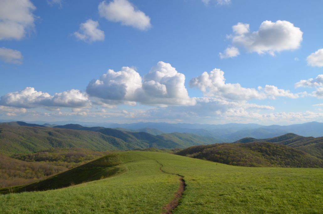
What Makes It Great
At 4,600 feet, Max Patch is not a particularly high mountain, yet the views from the top are highly acclaimed. The view’s infamy comes from its grass covered summit stage, which offers long range views in every direction. The view is framed to the southwest by the northern giants of the National Park: Mt. Guyot, Mt. Sterling and Big Cataloochee. The Plott and Great Balsam Ranges paint the southeastern skyline while the towering crest of the Black Mountains stands guard to the east and the Roans to the north. The Patch is surrounded by picturesque rolling hills and mountains leading up to these mighty ridge lines in three directions. To the west, however, an uninterrupted view over the lush expanse of Tennessee allows for a famously stunning sunset view.
Several trail options line the sides and summit of Max Path. From the parking lot, visitors can take the direct route to the summit for a 1-mile round trip or the 2.4 miles loop which circumnavigates The Patch. Those looking for a prolonged jaunt through the woods can follow the AT north or south as far as their hearts desire.
Who is Going to Love It
Photographers will find life-list photo opportunities atop Max Patch thanks to its ideal location on the western edge of the Appalachians. Bring your tripod along and set up for spectacular stellar and sunset shots. (Looking for more photogenic landscapes?) Romantics can take full advantage of Max Patch’s beauty by packing a blanket and picnic lunch to the easy access summit. Cap off your romantic evening as you return towards Asheville by taking a dip in the dreamy waters of nearby Hot Springs Resort. Anglers, bring your gear and cast a line in the Forest Service pond just past the parking area. The brave even venture to The Patch in winter for skiing and sledding amongst the sublime scenery.
Directions, Parking, & Regulations
A trio of route options leads to Max Patch from Asheville. If you choose to tackle these routes in winter, come prepared with an emergency kit and snow-worthy vehicle. There is no access fee for the trailhead. Camping is allowed in nearby areas, but is prohibited on the summit itself. Venture just past the summit for the prime locations. Bring your fury friend along for this outing: the area is dog friendly and they will thoroughly enjoy the grassy summit!
Featured image provided by Jake Wheeler


")


