Posts

Why waste the winter months hibernating indoors? Snow, ice, and frosty temperatures provide plenty of fodder for outdoor adventure from moderate to extreme. When winter weather rolls into the Southeast, North Carolina’s wild spaces are briefly and beautifully transformed, with much more to offer beyond black diamond downhill runs.
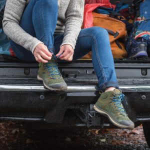
1. Snowshoeing

Requiring far less finesse than downhill or cross-country skiing, snowshoeing is ideal for ski school dropouts — and sturdily-built snowshoes can go places skis can’t. In the High Country just north of Boone, Elk Knob State Park consistently gets a more-than-generous dusting of snow. Even better, the park remains open throughout the winter, Elk Knob’s trails are prime for exploring by snowshoe after a coating of fresh powder.

In Beech Mountain, the loftiest town in the eastern United States (sitting at 5,506 feet), visitors can explore 30 miles of maintained trails, and snowshoe rentals are available at the Beech Mountain Resort. Novices can warm up on the recreation center’s 1/3-mile loop, while pros can head for the 8 miles of alpine tracks at the Emerald Outback, the town’s picturesque trail park. Tentative snowshoe converts can ease into the sport with a guided tour at Sugar Mountain Resort outside Banner Elk.

2. Winter Hiking

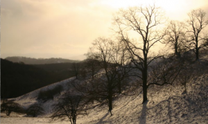
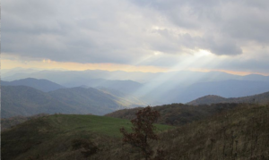
Explore Moses H. Cone Memorial Park, located on the Blue Ridge Parkway.
Christopher Sims

Head for North Carolina’s most popular trails when temperatures plunge, and less hearty hikers have gone home to roost for the winter. Waterfalls are among the state’s most popular hiking destinations, and in winter, most cascades are equally stunning, transformed into gravity-defying ice sculptures. Outside Brevard, head for Moore Cove Falls, in the Pisgah National Forest, accessible after a brief 0.7-mile hike. Or strike for the state’s most popular flume, Linville Falls. You can hike there via the trails that begin along the Blue Ridge Parkway (milepost 316). Even when the parkway is closed for winter weather, the falls are still accessible courtesy of trailhead located off NC 183 (on Wiseman’s’ View Road, NC 1238), outside the town of Linville Falls.

Or you can set out for one of the state’s most popular peaks, Max Patch, without the fall and summer crowds. An iconic southern Appalachian bald outside the town of Hot Springs, the 4,629-foot Max Patch is crowned with more than 300 acres of airy alpine meadows. The view-laden summit is accessible via a number of approaches, including the Appalachian Trail, but the most direct route is the 2.6-mile loop beginning at the parking area on Max Patch Road (SR 1182).


3. Rock Climbing

Some crags are better in winter, including some of North Carolina’s premier routes, which are best tackled after autumn’s crisp chill arrives. Slopes too toasty in spring and summer become climbable. Rising dramatically above a thickly wooded expanse of the Pisgah National Forest, Looking Glass Rock, just a few miles outside Brevard, is one of the largest monoliths in the country, providing unparalleled climbing opportunities. The massive granite dome is best climbed in fall and winter. For bouldering aficionados, Looking Glass also has plenty of problems, primarily collected along the base of the North Side of the monolith, accessible along the North Side Trail.

Southeast of Asheville in Chimney Rock State Park, the southern cliffs of Rumbling Bald make for another ideal winter climb, and the Rumbling Bald Trail also meanders past three boulder fields loaded with nearly a thousand problems.


4. Canopy Tours

North Carolina’s stunning landscapes become even more spectacular when viewed from above, and for outdoor-lovers immune to frosty temperatures, canopy tours aren’t just limited to spring or summer. Soar above the snow-frosted landscape in the North Carolina High Country with the two-hour Snowbird Tour at Hawksnest outside the town of Banner Elk. Or get a bird’s eye view of southern Appalachia with a winter zipline adventure at Navitat or Treetops Adventure Park in Asheville.

5. Ice Climbing

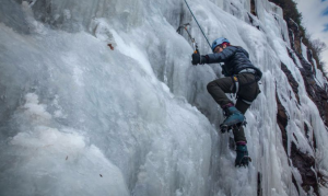
North Carolina is one of only two states where Fox Mountain Guides offers ice-climbing.

During icy winters, the land of waterfalls becomes a frozen wonderland, making North Carolina of the best ice climbing destinations in the south. For novices, Fox Mountain Guides operates in Pisgah National Forest and offers expert-led trips. North Carolina is the only state aside from New Hampshire where the climbing school offers ice-scaling expeditions.

For experts, when wintery conditions prevail along the Blue Ridge Parkway, the ice-glazed bluffs and crags of Doughton Park (milepost 240), provide an abundance of climbing options, including tackling the rock ledges framing the iconic roadway (climbing is permitted when the parkway is closed to vehicles). In the Nantahala National Forest, just outside Cashiers, the soaring cliff faces of Whiteside Mountain appear glazed with ice year-round. However, when the cliffs truly are iced over, Whiteside is transformed into one of the East’s top destinations for unflappable, peak-bagging pros — with options like Starshine, an iconic 200-foot route.

6. Cross-Country Skiing

While snowy forecasts may keep drivers off roadways, predictions of wintery weather will have cross-country skiers chomping at the bit. When snow and ice render North Carolina’s most stunning roadway — the Blue Ridge Parkway — inaccessible for vehicles, the thoroughfare is transformed into an extensive Nordic track for cross-country skiers. The High Country section of the parkway skirting Grandfather Mountain between Blowing Rock and Linville is beloved by local Nordic enthusiasts. Near the parkway’s southern terminus, the stretch of roadway around Soco Gap can also become skiable, loaded with close-ups of the frosty peaks of the Great Smoky and Plott Balsam mountains. Just off the Blue Ridge Parkway (milepost 292.7), the more than 20 miles of carriage-roads lacing the 3,500-acre Moses Cone Memorial Park morph into Nordic wonderland with a blanketing of snow.

7. Backpacking

The Appalachian Trail crosses the top of Max Patch Mountain, offering views of the Appalachian Mountains.
Jason A.G.

Winter camping makes for a singular outdoor adventure. Familiar landscapes can take on a different dimension—and present new challenges. Tackle a bite-sized thru hike in western North Carolina on the 30-mile Art Loeb Trail, rambling through the Shining Rock Wilderness and over some of the loftiest peaks in the Black Balsam mountains. The trail can be broken up into shorter sections for backpackers wanting to cut their teeth with a quick winter overnight.

For ambitious backcountry snow-bunnies, the Bartram Trail, named for 18th century naturalist William Bartram, winds through North Carolina and Georgia for 100-miles, mingling with the Appalachian Trail several times. The western North Carolina stretch rambles through pristine expanses of the Nantahala National Forest, culminating at the summit of 5,062-foot Cheoah Bald.

JOIN OUR NEWSLETTER

Featured image provided by Adam Fagen

What Makes It Great

Grandfather Mountain’s forests house plenty of wildlife and almost 200 different species of birds. Profile Trail hikers can spot woodland species such as warblers (especially in spring), scarlet tanagers, Louisiana water thrushes, and a numerous varieties of vireos. As the trail continues to spiral up the mountain, you’ll pass a great campsite, numerous breathtaking overlooks, and Shanty Spring, a cool and delicious fresh water spring located at about mile 2.7.

The last 0.3 miles will get your heart pumping, calves burning, and put you on your hands and knees as you climb up rocks along the steepest part. Once you reach the top of the Profile Trail, you’ll have two options: left or right. Swing left on the Grandfather Trail to reach Calloway Peak. It will take you 0.4 miles along the ridgeline and up three ladders to the summit of Calloway Peak.

Calloway Peak sits at 5,946 feet with the best views of Grandfather Mountain, Linville Gorge, and sometimes even the Charlotte skyline. John Muir described the sublime scenery from the summit as, “I couldn’t hold in, and began to jump about and sing and glory in it all!” Of the sunsets here, he said, “I only went out for a walk, and finally concluded to stay out till sundown, for going out, I found, was really going in.”

Bring some tasty snacks, plenty of water, and good company, and it will be a hike that you won’t regret.

Who is Going to Love It

This trail is for nature, adventure, and hiking enthusiasts. You’re gaining about 2,000 feet of elevation from start to finish. You’ll want to have comfy hiking boots, a backpack full of water, and your favorite snacks to stay fueled along the trail. If you have any knee or leg problems, make sure to bring trekking poles for additional support. There are benches along the trail for moments when you need a breather. It is well maintained and well traveled, although the last 0.3 miles can be rocky and uneven.

Intro

Beginning off of scenic highway 105, the Profile Trail offers hikers an opportunity to witness some of the spectacular and beautiful views the high country has to offer — views famed naturalist John Muir wrote about in 1898. You’ll start by lightly treading through the headwater streams of the Watauga River as it winds 3.1 miles through seven different types of natural communities, including northern hardwood, Canadian hemlock, and acid cove forests.

Directions, Parking, & Regulations

The trailhead is located 12 miles from Boone on Highway 105, ¾ of a mile North of the intersection of Highways 105 and 184.There is an official parking lot for this trailhead. Since this is a hiking favorite, the parking lot fills up quick; get there early to secure a parking spot. If the lot is full, you’re able to park along the shoulder of Highway 105 at your own risk. Trail access is free since, but you must fill out a permit at the trailhead information kiosk and bring the bottom section of the ticket with you on your hike.

Dogs are permitted, but must be leashed at all times.

If you plan to camp, remember to camp in designated areas, there are plenty of beautiful sites along the trail.

JOIN OUR NEWSLETTER

Featured image provided by Chelsie Mitchell

The wind just always seems to be blowing at the top of MacCrea Peak. The bare rock that caps the roughly chimney-shaped precipice offers no protection from the frigid gusts of the season. Just below, a ring of alpine forest (a biome common only in the Southeast at elevations of a mile high or greater) is dusted with bright white snow and shimmers under a sheen of ice. Far beyond the southern Appalachian spruce trees, valleys, and blue-hazed mountains seem to extend for eternity.

At once beautiful and treacherous, this is winter hiking at Grandfather Mountain State Park. Rugged rock scrambles, nerve-wracking high-altitude ladder climbs, and ice-slick chutes highlight the 12-mile trail system which laces its 2,500 acres.

Constant wind gives spruce trees and odd appearance of forward motion
Paul Geist

Grandfather Mountain was, until 2008, a privately owned park. The state park system bought the land but many of the attractions — gift shop, restaurant, animal habitats — remain and are operated by a non-profit enterprise. The front gate at the main entrance to the park is a reminder of those private ownership days and continues to charge a per person fee. However, since taking over the trail system, the Park Service has stopped collecting fees at the two other trailheads. Beginning your exploration of Grandfather Mountain at the western trailhead allows you to avoid the entrance fee and puts you in position to enjoy one of the greatest treks in this amazing park.

Snow covered trails make traction and navigation a bit tricky
Lisa Firullo

A Deceptive Start

A brown sign on NC 105, about ¾ mile from the junction of NC 184, locates the Profile Trail parking lot. During summer, this lot can overflow with eager trekkers, many of whom take on the more intermediate 7-mile trek to Calloway Peak  and back, but that’s rare on a cold winter day. Eventual updates, according to the Park System, will allow for more parking and a bathroom.

The first mile and half or so of the 3.1-mile Profile Trail doesn’t hint at the rugged terrain ahead. Mostly gentle climbs through a hardwood forest provide a good warm up, though. The trail turns abruptly steep and rocky but offers a well-protected lunch spot and water source at Shanty Springs just past the 2.5-mile mark.

The next bit of travel opens up to the first views of the day and may require a bit of “bear crawling” over exposed rock. Turn left onto the Daniel Boone Boy Scout Trail for a half-mile (each way) out and back hike to the top of Calloway Peak. The path near the top can become icy, and trekking poles offer a huge advantage.

Fir trees, bent by the constant onslaught of wind and fringed with icicles, frame the views from one of the highest peaks in the park.

Expansive views of Southern Appalachian Alpine Forest make the trek worthwhile
Lisa Furillo

Head back to the trail junction and continue straight to connect with the Grandfather Trail. Alpine Meadow, the open patch of grassy mountaintop about a half mile from the trail junction, is one of the best backcountry camping spots in North Carolina during warmer months.

Chutes and Ladders and “Batman-ing”

Another mile further on, the Underwood Trail splits to the right. Stay straight and you’ll soon come to a heavy wooden ladder, the first of several, which leads to the top of MacCrea Peak. Cresting the big rock is well worth the diversion to take in 360 degrees of Blue Ridge Mountain views.

Craggy rock faces create beautiful ice flows on the trail
Paul Geist

After a visit to MacCrea, the next stretch of trail includes the chutes and ladders that make this trek famous. Shimmying, a la Batman from the campy 1960’s TV show, down bare rock faces requires a light grip on attached cables. Several more ladders — needed to avoid free climbing steep drop offs of exposed rock — make this section particularly troublesome for dogs, although many can complete it with a little help. These craggy overhangs also produce some crazy-cool ice structures perfect for your next profile picture.

Mile High Bridge

The final turnaround point is the large parking area on the top of Grandfather. As this is also the stopping point for those driving up from the main entrance, the lot is often bustling with families who’ve come for a picture on the mile high swinging bridge. While plenty sturdy, the sway of the 228-foot pedestrian suspension bridge (the longest of its kind in the U.S.) can cause shaky knees in even mild acrophobics. The gift shop, restaurant, and bathroom facilities are here as well. Once you’ve had your fill, head back the way you came to the Profile Trail parking lot.

A frosted sheen of snow and ice brings a different look to Grandfather
Joe Giordano

Tips for your first winter hike at Grandfather

    • Plan plenty of time for your return hike. Grandfather is no place to be stuck after dark if you’re not camping.
    • The total hike to the main parking lot and back is 12 miles. Even experienced hikers rarely complete it during the reduced daylight hours of winter, many choosing to turn around at MacRae Peak or the Alpine Meadow. The shortened hike still offers an incredible variety of views and experiences.
    • While some hikers bring dogs to Grandfather, it’s probably a good idea to leave your four-legged pal at home on your first trip, especially in winter.
    • With the potential for slick ice spots and the guarantee of rugged rock, hiking poles are strongly suggested.
    • Wisteria Gastropub is conveniently located on the way back to Charlotte in Morganton. They offer a fantastic southern-spin on farm to table meals and a well-rounded beer list.

JOIN OUR NEWSLETTER

Featured image provided by NC Orchid

Thousands of years ago, when extreme cold gripped the North American continent, flora and fauna most suited to northern latitudes migrated south, covering what is now North Carolina. As the cold retreated and temperatures climbed, the trees and animals more suited to warm weather returned. Except, that is, for those living on the highest peaks in the state.

Like islands of alpine forest in a sea of temperate climate, the rounded precipices of North Carolina’s loftiest mountains still have the look and feel of their Canadian counterparts — none more so than Mount Mitchell, standing 6,684 feet above sea level.

Coated in crystalline frost even while surrounding valleys are bathed in relative warmth, Mount Mitchell is among the best places in North Carolina to experience a real winter wonderland. Here we offer four reasons to brave the fickle conditions on the East’s loftiest peak during its harshest months.

1. You’ll earn serious bragging rights.

Bent trees and horizontal ice formations tell the tale of powerful winds that frequently sweep across the top of the mountain. North Carolina State Parks
Bent trees and horizontal ice formations tell the tale of powerful winds that frequently sweep across the top of the mountain.
North Carolina State Parks

Hiking to the top of the highest peak east of the Mississippi is a formidable goal any time of year. But in winter, when the Frasier fir trees are dusted with snow and a brutal wind forms sideways icicles, hearty hikers gaining Mitchell’s summit become part of a special club.

The Mount Mitchell Trail is the most popular summit route in the state park. This 6-mile, one-way trail begins at the Black Mountain Campground and wanders through several distinct biomes on the way up. Mountain laurel and rhododendron line lower elevation creek beds. Mountain maple, spruce, and birch trees crowd for sunlight midway up, while the last remnants of an alpine fir forest cap the final stretch.

The Black Mountain Range, a 15-mile stretch of peaks anchored by Mount Mitchell, stands high enough to affect the weather. Temperatures have dropped to minus 34 degrees while wind gusts of more than 170 mph have been recorded at the peak — and it’s important not to take a winter day here lightly. These conditions certainly add to the challenge, but also to the accomplishment.

2. It’s a different world in winter.

“Post-holing” through a heaping layer of snow can make the already challenging hike to the top of Mount Mitchell a real beast. North Carolina State Parks
“Post-holing” through a heaping layer of snow can make the already challenging hike to the top of Mount Mitchell a real beast.
North Carolina State Parks

During spring, multi-hued flowering bushes line babbling creeks on the mountainside. Songbirds fill the trees and lush vegetation buffers the trail in an expansive green carpet.

But winter brings an entirely different mood to Mount Mitchell. There are no songs from the forest now; just the crunch of your footsteps on frozen trail reverberating off weathered tree trunks. On a rare, still day, there is no other sound. On a typical day, however, the whistle and howl of wind overhead surrounds you.

Down low, at the beginning of your hike, branches are coated in a heavy snow. Nearer to the peak, horizontal ice formations and bowed trees are static reminders of punishing winds. Where a blue haze might limit views in the summer, clear winter days provide vistas of frosted peaks up to 80 miles away. It’s a special kind of serenity that only a winter hike affords.

3. You’ll savor plenty of solitude.

The challenge of climbing some 3,600 feet to the top of Mt. Mitchell may be substantial, but in good weather it’s a common undertaking. No surprise, then, that the Mount Mitchell trail can be heavily trafficked in summer. And at the top, where a large parking lot sits adjacent to the snack bar and museum, families and groups of motorcyclists can crowd the view.

In winter, however, the snack bar and museum are closed for business. Difficult road conditions, school schedules, and the tough climate keep many visitors at bay. The quiet of the trail continues all the way to the top. It’s a memorable outdoor adventure not possible on busy summer days, making the wind-burnt skin and cold toes well worth it.

4. You’ll find plenty of post-hike happiness nearby.

An 800-degree stone oven provides the tell-tale char on the crust at Fresh Pizza and Pasta. Don’t want it? Just let them know when you order. Rob Glover
An 800-degree stone oven provides the tell-tale char on the crust at Fresh Pizza and Pasta. Don’t want it? Just let them know when you order.
Rob Glover

A winter exploration of Mount Mitchell will chill your bones and burn some serious calories. These days are made for hearty craft beer and huge, wood-fired pizza.

This perfect one-two punch awaits in the quaint town of Black Mountain, due south of Mount Mitchell. Begin with a stop at Fresh Wood Fired Pizza and Pasta. Settle into this cozy restaurant and watch while bubbly-crusted pizzas are pulled from an 800-degree stone oven. (The typical pie comes with a charred crust which creates a wonderful flavor, but you can ask them to leave it un-charred if you prefer.) The calzones are the size of a small RV and the beer selection is admirable. Leaving hungry, even considering your incredible effort earlier in the day, is unlikely.

If You Go:

  • Check the weather report before setting out. It changes quickly here, and being caught in a blizzard with howling winds is no joke.
  • Bring your hiking poles for this trek. They can provide a lot of support on an icy trail.
  • Check the park website for closures. The park staff works hard to clear roads, but they may shut down for a day or two after a heavy snow.

JOIN OUR NEWSLETTER

Featured image provided by North Carolina State Parks

Intro

Sitting at 5,506 feet in the heart of Appalachia, you’ll find Beech Mountain. Beech features amazing skiing and snowboarding terrain accompanied by an array of après activities that are sure to make your visit memorable. Grab your skis or board and make the two hour trip from Asheville.

Who is Going to Love It

Beech Mountain Resort takes pride in cultivating new shredders to enjoy the mountain. They offer free skiing and snowboarding lessons with the purchase of rental equipment, Monday-Thursday. Beech is a certified Burton Learn To Ride (LTR) Center. The field of instructors make learning to ride a blast and the learner specific equipment has beginners shredding in no time. Snow Kamp is also available for children 3-5 years old and provides parents with an all-day childcare option.

What Makes It Great

Beech Mountain Resort boasts eight impressive lifts including a high-speed quad that takes skiers and riders directly from the base to the top of the mountain. The eight lifts service a total of 95 skiable acres on 15 slopes. Check out the Beech Mountain Trail Map for more details on the terrain.

You’ll also find the Powder Bowl freestyle terrain park maintained by a core group of shredders. Powder Bowl is home to advanced and intermediate features including boxes, rails, and kickers. Beginners can hone their skills in the rider-friendly Meadows freestyle park.

The View Haus, Beech Mountain Resort’s largest facility, was recently renovated to provide a comforting mountain lodge atmosphere with all new amenities. How about an local craft brew for your après ski thirst quencher? Beech Mountain Brewing Co. is located in the Ski Village with a brand new deck and ski-in ski-out access! You’ll find plenty of dining and entertainment options at Beech, making this the choice for longer North Carolina skiing and snowboarding stays.

Beech Mountain Resort hosts many large and small events including live music, trivia, and the totally tubular Retro 80s Weekend.

Directions, Parking, & Regulations

The drive from Asheville to Beech Mountain Resort will take you 1 hour and 45 minutes. Check out lift ticket rates and current conditions before you head up the mountain.

JOIN OUR NEWSLETTER

Featured image provided by Courtesy of Beech Mountain Resort

Intro

 “Come Ski the Wolf.” Wolf Ridge Resort offers this enticing invitation. How could a skier or snowboarder turn down an invitation that sounds so cool? The greatest thing about coming on up to Ski the Wolf? It only involves a 35 minute scenic drive from Asheville!

What Makes It Great

Wolf Ridge Resorts stands five miles off of I-26 on a scenic highway. The Wolf is a favorite of locals looking for a quick trip to the ski slopes. The Wolf operates on 62 acres of enjoyable ski terrain that is covered in an average of 60-80 inches of snow per year. Skiers and snowboarders will enjoy Wolf Ridge’s recent terrain makeover which includes updates to the park and widened trails which provide better access to the lodge. Wolf Ridge’s Lower Lodge serves as a full service ski station for visitors, offering tickets, rental equipment, dining, and a gift shop. Wolf Ridge Resort has a variety of year-round accommodations available that provide a wonderful base camp.

Wolf Ridge is a family oriented resort. They help “share the stoke” with kids and beginners through their PSIA/AASI accredited Snow Sports School and their “magic carpet” serviced tube run.

  • Number if Slopes: 15
  • 40% Beginner
  • 40% Intermediate
  • 20% Advanced
  • Annual snow average 60-80 inches
  • Annual snow record: 148 inches

Download the Wolf Ridge Trail Map for an in-depth look at their terrain.

Who is Going to Love It

While it’s a primarily geared towards beginners and intermediate skiers and snowboarders, there are also deals for everyone!

  • 2 For Tuesday: Buy 1 Lift Ticket, Get 1 Free
  • Women’s Wednesday: ½ price lift tickets for all ladies
  • Thursday College Night: $15 lift tickets with student ID
  • Active Military: $15 off lift tickets with ID

Wolf Ridge is also open for night skiing.

Directions, Parking, & Regulations

Wolf Ridge is the closest ski resort to downtown Asheville. A 35 minute scenic drive up I-26 will bring you to the base of Wolf Ridge Resort.

Tickets are reasonably priced and start at $40 for adults. Visit Wolf Ridge’s website to purchase lift tickets in advance.

JOIN OUR NEWSLETTER

Featured image provided by Photo Courtesy of Wolf Ridge Resort

Intro

Sugar Mountain Resort boasts one of the highest vertical drops and largest amounts of skiable terrain in Western North Carolina. From Asheville, a scenic hour and forty minute drive into the North Carolina high country will have you skiing on one of the area’s finest resorts. Make the trip for a day of fun in the snow or check into one of Sugar Mountain’s variety of lodging options for a multi-day winter excursion.

What Makes It Great

Sugar Mountain Resort is known not just for skiing and snowboarding, but for an array of activities to entertain the entire family. Not comfortable on the slopes? Sugar runs a 700 foot tubing run which is serviced by a “magic carpet lift” that stays open late for evening entertainment. Adjacent to the tube run is a 10,000 square foot ice skating rink. If you are looking for winter exercise, Sugar Mountain offers guided snowshoe tours throughout the week. Tours include a one hour hike and snowshoe rentals.

  • Summit Elevation: 5,300 feet
  • Base Elevation: 4,100 feet
  • Vertical Drop: 1,200 feet
  • Total Skiable Acres: 125 (100 at night)
  • 14% expert
  • 52% intermediate
  • 34% beginner
  • Number of Lifts: 7

Who is Going to Love It

Skiers and snowboarders love the terrain offered at Sugar Mountain during the winter.

In recent years, Sugar has also begun to offer year round activities. If you find yourself visiting the North Carolina mountains in summer, Sugar Mountain is a great place to quench your thirst for hiking or mountain biking. Many miles of free access trails are available during daylight hours in the summer months. Get a detailed trail map before your visit and check out this video from Sugar Mountain Resort’s expert downhill track. Expert riders can experience the same downhill adventure as a USA Cycling National downhill racer on what is considered one of the most demanding and thrilling downhill courses on the East Coast.

Directions, Parking, & Regulations

The drive from Asheville to Sugar Mountain Resort is beautiful and takes 1 hour and 40 minutes from downtown. Lift tickets to Sugar are incredibly reasonable. Parking can easily be found at the resort and they also run a shuttle system to help you get around once you’re at the mountain.

JOIN OUR NEWSLETTER

Featured image provided by Mark Clifton

Asheville continues to rank high on travel lists for outstanding food, beer, and popular outdoor activities such as hiking and biking, but hidden behind all of the hype are some of the best disc golf courses in the North Carolina. The goal of disc golf is the same as traditional golf: get the disc from the tee to the hole in the fewest strokes possible; however, instead of clubs, balls, and a decent chunk of cash, all you need is your arm and a disc to have a good time. Check out this list of the Asheville area’s top disc golf courses, all within a half hour drive or less.

Western North Carolina’s subtropical climate and moderate seasonality, these courses are accessible during most of the year. Barren trees may allow a better view of cages in the winter, but make sure you’re always prepared for the trail with the proper footwear. Stop by any Diamond Brand Outdoors location for a large selection of KEEN hiking shoes, boots, and sandals to ensure your time on the course is as enjoyable as possible.

Richmond Hill Disc Golf Course

Richmond Hill Disc Golf Course is an 18-hole course working its way throughRichmond Hill Park just north of downtown Asheville. The course is hilly, densely wooded (the club logo has a poison ivy border), and boasts one set of tee pads with multiple basket placements. The closet course to downtown, Richmond Hill is preserved by a dedicated community of golfers.

280 Richmond Hill Dr, Asheville, NC 28806

Black Mountain Disc Golf Course

Black Mountain Disc Golf Course is an 18-hole course just outside of this beautiful mountain village in Veterans Park. The course features relatively short, yet really fun holes that wind their way through moderate hills with scattered trees. The local community of dedicated disc golfers includes John Garcia, the owner of nearby Lookout Brewing Company.

10 Veterans Park Dr, Black Mountain, NC 28711

Waynesville Disc Golf Course

Waynesville Disc Golf Course sits just outside of downtown at the Waynesville Recreation Center. For the most part, it’s a wide open course comprised of long tee throws and beautiful views of the nearby mountains. A course map can be found in the recreation center office and main kiosk.

550 Vance St, Waynesville, NC 28786

Jackson Park Disc Golf Course

Just south of Asheville, one of the newest courses in the region is located near downtown Hendersonville in Jackson Park. The course offers the widest variety in WNC with open, partially wooded, and densely wooded holes on moderate to steep hills. Multiple concrete tee pads, short and deep basket positions, and beautiful locust benches on every hole make this course a real gem.

801 Glover St, Hendersonville, NC 28792

Lake Julian Disc Golf Course

Lake Julian Disc Golf Course lies along the shores of South Asheville’s Lake Julian and now hosts a full 18-hole course following its August 2017 expansion (which included new concrete tee pads). This course is relatively flat compared to the other courses in the area and has everything from water-front holes to holes that weave their way through the dense woods (watch out for poison oak and poison ivy).

406 Overlook Road Ext, Arden, NC 28704

UNCA Disc Golf Course

UNC Asheville has established a 6-hole disc golf course for both students and the community to test out. The course is primarily hilly and wooded with a few holes in the open. Due to the course’s location on UNCA’s property and its limited holes, it is very accessible and it doesn’t take too much time to walk!

2500 University Heights, Asheville, NC 28804

Sandhill Nature Trail Disc Golf Course

Sandhill Disc Golf Course is part of Buncombe County Sports Park and hosts a full 18-holes that make their way through a hilly and wooded area. This course is not far from downtown and incredibly accessible due to Buncombe County Sports Park’s parking and facilities. However, remember to throw wisely because this park hosts a lot of other facility users.

58 Apac Dr, Candler, NC 28715

JOIN OUR NEWSLETTER

Featured images provided by KEEN, Official Sponsor of Your Next Adventure.

Lake Julian image courtesy of The Night Canopy. Special thanks to Justin Menickelli.

Hide A Boat isn’t just a fun way to sound Canadian. It’s an easy way to purchase an awesome gift and keep it hidden even if you’re personally at a loss for space. It’s a service we offer all year, but comes in especially handy during the holiday season.

Just stop in our flagship store located in South Asheville’s Parkway Center on 1378 Hendersonville Road. Our team of experts will help you choose the perfect recreational, whitewater, or fishing kayak or SUP from LiquidLogic, Native Watercraft, NRS, Perception, or Wilderness Systems. You’ll even get 20% OFF all paddling accessories and free installation of any Thule rack system purchased at the store ($75+ value).

We’ll store your purchase for free until you’re ready to pick it up. Or, better yet, we’ll deliver it for free within 20 miles of our store! Let us do the work while you wait to collect your hugs.

JOIN OUR NEWSLETTER

See any team member for complete details.

Intro

The twin-peaked, rugged profile of Chimney Tops gained infamy with its appearance on the cover of Horace Kephart’s classic, Our Southern Highlanders. The summit of this 4,724-foot peak has weathered away over the centuries leaving behind a backbone of folded metamorphic rock which has turned into a playground for the adventurous. The trail to the Chimneys was badly damaged several years ago by torrential downpours and flooding. Thanks to the Great Smokies’ Trails Forever Program, a newly renovated trail takes hikers from the trailhead to the airy summit by way of a steep, intricately constructed, two mile trail.

What Makes It Great

The trail to the Chimneys quickly becomes beautiful as it passes over Walker Camp Prong – thanks to the newly constructed and environmentally friendly bridge system– right out of the gate. Get ready to climb after crossing the creek: Chimney Tops’ trail gains 1,700 feet in elevation as it introduces your quads to hiking in the highlands! The trail’s forever crew has created a network of 360 rock steps and nearly 300 log steps which lead to the top of this “stairway to heaven.”

After finally gaining the ridgeline, your legs may be wary Give them a rest to refresh for the fun to come! A short traverse on an airy ridgeline leads to the highlight of the trail: a short, but very exposed, scramble to the crown of the Chimneys. Although technical gear is not needed to ascend this last section, you will see many tourists humbly end their day at the base of this scramble. Take your time, maintain at least three points of contact with the rock at all times, and carefully make your way up the rocky backbone leading to the summit and 360 degree views.

Who is Going to Love It

Thrill seekers will find just what they are looking for atop the Chimneys. An unsanctioned, yet unbelievably fun climb past the first Chimney, across a rocky ridge, and onto the second Chimney will get your blood flowing and guarantee solidarity atop this popular destination. However, this shot at solitude is not for the faint of heart. The route begins with a mandatory down-climb and technical maneuvers are required across some highly exposed sections to reach the second Chimney.

The view westward (across the rolling expanse of Eastern Tennessee) is uninterrupted and affords spectacular sunset views for those willing to descend under the glow of a headlamp.

Directions, Parking, & Regulations

Chimney Tops Trailhead can be found off route 441, on the Tennessee side of the Great Smoky Mountains National Park. The Drive from Asheville takes 1 hour and 45 minutes. Experiencing the Chimneys is worth every second of it! Hiking does not require any fees or permits.

Due to terrain and National Park regulations, dogs are not allowed on Chimney Tops Trail.

JOIN OUR NEWSLETTER

Featured image provided by Stewart Photography

Events

Nothing Found

Sorry, no posts matched your criteria