Posts

When you live near a city, it can be easy to forget just how many stars are in the night sky. But if you take the time to get away from the light pollution, spread out a blanket, and look up, there are more to see than you can imagine. It’s relatively easy to find a dark sky out west, but what about in the southeast? Where can you escape the city lights and find a truly dark sky for stargazing? Here are six of the best places in the southeast to take in the majesty of the night sky.

Before you head out, read this quick guide so you know what to expect and what to look for up there.

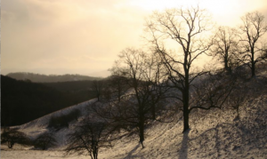
1. Staunton River State Park in Scottsburg, Virginia

43fC5b0lcISSyyYQOe0ki8
Find your favorite constellations at Staunton River State Park.
Virginia State Parks

Designated a Dark Sky Park in 2015, Staunton River State Park is just 25 miles from the North Carolina border and sits between the Dan River and the John H. Kerr Reservoir. There are plenty of opportunities for fishing, swimming, and hiking, but the real draw is once the sun goes down. The park rangers host interpretive programs and there are telescopes available to rent — or you can just show up with your blanket. Bring a tent and spend the night at the park’s campground or rent one of the historic cabins built by the Civilian Conservation Corps in the 1930s.

2. Blue Ridge Observatory and Star Park in Burnsville, North Carolina

yk0YsmWnfMumsaO0EQCKW
The Milky Way blazing from the Blue Ridge Parkway.
lawepw

If you’ve ever driven along the Blue Ridge Parkway, you know it’s some of the most beautiful scenery in the United States. But if you haven’t seen it at night, you’re missing out on the real magic! The Star Park is located in the Appalachian Mountains in Burnsville, North Carolina, and is managed by Maryland Community College. Surrounded by the Pisgah National Forest, it’s an experience that you won’t soon forget.

Note: there is no camping allowed in this park.

3. Portsmouth Island, North Carolina

The Outer Banks in North Carolina is already a decent spot for stargazing, but if you’re serious about checking out the Big Dipper, head to Portsmouth Island. The 13-mile-long island is just south of Ocracoke Island, making it the southernmost in the chain of barrier islands. The only way to get there is by boat and there is plenty of fishing, shelling, and exploring to keep you busy during the day. Set up camp pretty much anywhere you want, and enjoy the peace and tranquility of one of the wildest islands in the Outer Banks. Facilities and amenities are very limited so make sure you are prepared before taking a trip out to Portsmouth.

4. Obed Wild & Scenic River in Wartburg, Tennessee

You might be familiar with the Obed Wild & Scenic River because of all the outdoor adventures to be had, but what you may not know is that it’s also a newly-designated Dark Sky Park. The National Park Service regularly hosts night sky outings and the Knoxville Observers and ORION Astronomy Clubs also host astronomy programs in the area. The park service offers a Junior Ranger Night Explorer program, making this spot particularly family-friendly.

The park staff is also working to keep the sky around the Obed dark by prohibiting any permanent outdoor lighting.

5. Stephen C. Foster State Park in Fargo, Georgia

5v4i6vIRI4sSEKyowka4wM
Star trails at Stephen C. Foster State Park.
Alan Cressler

This 80-acre park might not cover a large space, but it does offer the unique opportunity to go stargazing in the Okefenokee Swamp, the country’s largest blackwater swamp. Stephen C. Foster State Park is part of the Okefenokee National Wildlife Refuge, so you can’t stay overnight, but the park is open until 10 p.m., which gives you plenty of time to get your stargazing fix. Sign up for the Swamper’s Guide to the Galaxy, a Constellation Cruise, or a Paddle Under the Stars to learn more about what you can see in the sky—and in the swamp!

6. Pickett CCC State Park and Pogue Creek Canyon State Natural Area in Jamestown, Tennessee

This state park lies within the Pickett State Forest in the Cumberland Mountains and is very close to the Big South Fork National River and Recreation Area. This means there’s a whole lot of nature and not a lot of light pollution. The area earned its Dark Sky Park designation in 2015, and the staff host several night sky programs in the summer. The park has regular campsites, group campsites, and cabins you can rent and stay for a whole weekend of stargazing.

JOIN OUR NEWSLETTER

Featured image provided by Virginia State Parks

When you think of “wilderness,” what image pops into your brain? I’d wager a lot of you first thought of snowcapped peaks — or maybe a convoluted canyonland, a lake-pocked boreal forest, or some windswept desert badlands.

All of these places are undoubtedly amazing, and worldwide they certainly account for some of the deepest backcountries left on the planet. But in my mind’s-eye, there aren’t many landscapes that so embody “wild” as a swamp: dark, waterlogged, chirring with insects and frogsong — or, in northern wintry mode, a frozen-over backwater of tussocks, deadfall, and horned owls.

One of America’s foremost wilderness sages, ol’ Henry D. Thoreau, also ranks among the world’s most quotable swamp fans. Should you doubt the healthful stimulus a swamp provides the human spirit, just dip into Henry’s writings. “I enter a swamp as a sacred place — a sanctum sanctorum. There is the strength — the marrow of Nature” (“Walking”). Or, from the same essay: “Yes, though you may think me perverse, if it were proposed to me to dwell in the neighborhood of the most beautiful garden that ever human art contrived, or else of a Dismal Swamp, I should certainly decide for the swamp.”

Here, here!

Though the people often label any old morass a “swamp,” it’s got a specific definition. Very roughly, it’s a wetland dominated by woody vegetation: trees or shrubs. Marshes, by contrast, are more open environments with herbaceous plants such as sedges and cattails. A bog can look rather like a swamp with its stunted timber, but it’s an acidic mire that builds up peat and is usually thick with sphagnum moss.

(You’ll notice the Everglades isn’t on the list below: Though it does contain many small swamps in the form of cypress domes and willow/bay thickets, and though it borders two of the big swamp complexes treated here, the true “Everglades” refers to a wholly unique marsh, not swamp, ecosystem.)

Let’s take a mucky tour of some of the most important swamps in America: some of the biggest, yes, but also much smaller ones still notable for their old-growth character — or for being awesomely intimidating pocket wildernesses in the midst of heavily peopled surroundings.

The Great Dismal Swamp (Virginia/North Carolina)

The iconic Great Dismal Swamp National Wildlife Refuge, home to Lake Drummond, one of only two natural lakes in Virginia.
USFWS

“Never was Rum, that cordial of Life, found more necessary than in this Dirty Place.” That was the cheery endorsement offered of the Great Dismal Swamp in the mid-1700s by Colonel William Byrd III, who named this darkly timbered wetland wilderness that once likely covered a million acres on the Atlantic Coastal Plain of southeastern Virginia and northeastern North Carolina. More than 112,000 acres of the swamp, heavily impacted by logging, draining, and development, constitute the Great Dismal Swamp National Wildlife Refuge, with North Carolina’s Dismal Swamp State Park bordering the southeastern end.

Diminished though it may be, the Great Dismal Swamp — often considered the most northerly of the Southeast’s great bottomland swamps stretching down to Florida — remains one of America’s most evocative wetlands.

Like some Bahamian blue hole, Lake Drummond (the biggest natural lake in Virginia) forms a big watery eye in the middle of the refuge. Its huge baldcypress hulks are reminders of the stature of the old-growth swamp forest that once covered most of the basin. Baldcypress, water tupelo, and Atlantic white-cedar used to dominate the canopy, but red maple covers the most acreage today, having colonized extensive habitat in the wake of logging, fire suppression, and other human modifications. (You’ll find red-maple swamps all the way from Maine to Florida.) Meanwhile, marsh is developing in the extensive scar south of Lake Drummond created by the lightning-sparked Lateral West Fire, which raged for 111 days in 2011.

The Great Swamp (New Jersey)

You can bet Thoreau would appreciate the fact that the sodden groves and rank fern beds of the Great Swamp bristle only 26 miles from Times Square. He would also appreciate the efforts of the local citizens who banded together in 1959 to thwart the conversion of these forested wetlands, marshes, ponds, glades, and hardwood uplands into a jetport proposed by the Port Authority of New York. The 3,000 acres they donated to the U.S. Fish and Wildlife Service became the core of the Great Swamp National Wildlife Refuge, now more than twice that size. The refuge’s eastern half composes a federal wilderness area.

The Great Swamp, which edges Long Hill of the Watchung Mountains to the south, formed thousands of years ago in the emptied basin of Glacial Lake Passaic. The Passaic River and a few of its tributaries, namely Black Brook and Great Brook, drain the swamp to the west.

Get your bearings on the short boardwalk trails at the Wildlife Observation Center in the middle of the refuge or the Great Swamp Outdoor Education Center, then foray into the depths along longer paths penetrating the Great Swamp Wilderness.

The Congaree Bottomlands (South Carolina)

Think all of America’s big trees are on the West Coast? Think again: The floodplain forests and river swamps in Congaree National Park — the largest remaining old-growth bottomland hardwood forest in the Southeast — flings up a truly mighty canopy, one of the loftiest of any deciduous forest in the world. Congaree’s cathedral groves include a 167-foot-tall loblolly pine, a 162-foot-tall swamp tupelo, a 160-foot sweetgum, and numerous other champion trees.

You can tent out in a pair of developed campgrounds or in the backcountry, penetrated by a trail network and paddling routes along Cedar Creek and the Congaree River itself.

The Four Holes Swamp (South Carolina)

South of the Congaree in the Edisto River basin, the Four Holes Swamp includes the country’s largest old-growth stands of baldcypress and water tupelo, the botanical tag-team that dominates so many Southeastern river swamps. Home to the 17,000-plus-acre, National Audubon Society-owned Francis Beidler Forest, this alligator-, cottonmouth, and anole-prowled blackwater swamp—once a sanctuary for the Natchez Indians and, during the Revolutionary War, the “Swamp Fox” Francis Marion—is named for the deep ponds or “holes” sprinkled within it. Some 1,800 acres of the forest are virgin, defined by giant baldcypresses above an under-canopy of tupelo: trees that may be 1,000 years old or more.

The Four Holes Swamp ranks among the most awe-inspiring of America’s wetlands, and you can get a taste for it with a walk on the Audubon sanctuary’s 1.75-mile boardwalk trail or a canoe or kayak safari (reservations required) through the blackwater channels.

The Okefenokee Swamp (Georgia/Florida)

Camping at Floyd's Island during a 3-day canoe trip in the Okefenokee National Wildlife Refuge.
Camping at Floyd’s Island during a 3-day canoe trip in the Okefenokee National Wildlife Refuge.
Timothy J

Shadowy sloughs through Spanish-moss-spangled baldcypress, jungly tree hammocks, waterlily lakes white with blossoms: The Okefenokee may well be the country’s archetypal swamp. Covering some 700 square miles on the Georgia-Florida line, it’s also one of the biggest. Its sandy basin, hemmed on the east by an ancient dune called the Trail Ridge, serves as headwaters for the Suwannee River (flowing to the Gulf of Mexico) and the St. Marys (flowing to the Atlantic). The floating rafts of peat scattered in the so-called “prairies” of the swamp, which ultimately will be colonized by bays and other plants, explain the meaning of Okefenokee: “Land of the Trembling Earth.”

A multiday canoe trip into the Okefenokee National Wildlife Refuge locks you into the slow rhythm of the place. Well, for one thing, it’s slow paddling, given the twisting channels, the often-shallow water, and the obstructions of peat islands and emergent vegetation. You’ll probably see more than one gator hauled up on a log; the sight of a swamp black bear’s a rarer thrill.

The Green Swamp (Florida)

Along the lines of the sharp dichotomy between Manhattan and Jersey’s Great Swamp, the Green Swamp of Central Florida stakes out a reptile-thick wilderness within a stone’s throw or two from Walt Disney World (hacked out of a swamp, mind you). Covering roughly 900 square miles, the swamp — actually a diverse matrix of cypress swamps, riverine and bottomland hardwood forests, hammocks, marshes, and upland woods — is one of the Sunshine State’s major headwaters, giving rise to numerous rivers and daily funneling hundreds of thousands of gallons of water per square mile into the Florida Aquifer, upon which millions of people rely.

Some 110,000 acres of the landscape compose the Green Swamp Wilderness Preserve overseen by the Southwest Florida Water Management District. Hiking opportunities abound, not least on a long segment of the Florida National Scenic Trail.

Southwest Florida Mangrove Swamps

Slacklining during a canoe trip in the Florida Mangrove swamps.
Tristan Loper

The ragged seashore of Southwest Florida is one of the wildest coasts in the country. It’s also one of the greatest swamplands, given it’s dominated by mangrove jungle (aka mangal). Mangrove swamps are massively significant worldwide as nurseries for fish and other marine life as well as stabilizing bulwarks against wave erosion and hurricanes. They’re mostly a tropical feature and therefore rare in the U.S., but the Ten Thousand Islands and the mangal sloughs off the Big Cypress and the Everglades create one of the most significant mangrove mosaics in the Western Hemisphere.

Though the giant bird rookeries of the past have been reduced, the Southwest Florida mangal is still thronged with feathered life—egrets, ibises, cormorants, pelicans—and manatees, dolphins, and tarpon cruise the bays. American crocodiles, meanwhile, find refuge in the mangrove margin of Florida Bay. For experienced boaters, the Wilderness Waterway serves as the classic journey through this magnificent backcountry.

The Big Cypress Swamp (Florida)

The Florida Trail also strikes through the one-of-a-kind wilderness of the Big Cypress Swamp, a vast patchwork of cypress domes and “strand” swamps, pinewoods, palm savannas, and tropical hammocks edging the Everglades to the northwest. The name today is more evocative of the extent of the country (a watershed of more than 2,000 square miles) than the size of the baldcypresses, given the old-growth titans were nearly completely lumbered out. But take a stroll on the boardwalk through the Corkscrew Swamp, a protected pocket of old-growth in the far northern Big Cypress, to get a taste for how utterly massive those buttressed conifers can grow.

The Corkscrew Swamp is an Audubon sanctuary, separated by development from the complicated patchwork of publicly owned lands encompassing most of the remaining Big Cypress Swamp: among them the Fakahatchee Strand State Preserve, the Florida Panther National Wildlife Refuge, and the Big Cypress National Preserve. The latter 720,000-acre parcel, managed by the National Park Service, borders Everglades National Park to the east and south.

Hikers and backpackers in the sprawling Big Cypress National Preserve outback have the chance of glimpsing a Florida black bear or a Florida panther, that puma subspecies now restricted to South Florida, more common here than in the Everglades. And particularly in the winter dry season, waterways are crammed with egrets, anhingas, wood storks, alligators, and other critters.

The Atchafalaya Swamp (Louisiana)

A tour boat rests serenely in Atchafalaya Basin.
Matthew Levine

Encompassing some 900,000 acres of baldcypress-tupelo bayous and bottomland hardwood forests, the Atchafalaya (“Long River” in the indigenous Chitimachas language) Swamp is often called the biggest riverine swamp in the U.S. It hugs most of the Atchafalaya River’s 140-mile corridor extending from just south of the Mississippi-Red River confluence to the vast marshy Atchafalaya Delta on the Gulf of Mexico (its own superlative wetland complex).

Harvested for oil, gas, and timber, long hunted and fished, the Atchafalaya Swamp is also a major haven for wildlife, including the rare Louisiana black bear. The swamp’s intimately tied to the Mississippi River: The Atchafalaya River has long been a flood spillway for the Mississippi, and were it not for Army Corps of Engineers regulating flow, the Mississippi might well abandon its current delta and follow the shorter seabound course through the Atchafalaya.

Heavily impacted by humanity, the Atchafalaya is nonetheless big and wild enough to give a major sense of swamp primeval. The Atchafalaya National Wildlife Refuge makes a good jumping-off point.

The Honey Island Swamp (Louisiana/Mississippi)

The 70,000-acre Honey Island Swamp in southeastern Louisiana and southwestern Mississippi’s Pearl River Basin sums up much of the allure of America’s swamplands. For one thing, it’s one of the wildest and most tucked-away: a remote corridor of hardwood and baldcypress/tupelo swamp in the bottoms between the West Pearl and Pearl rivers, grading into marshlands fronting the Gulf lagoon of Lake Borgne. And for another, like swamps around the world, it’s drenched in lore as an outlaw hideout. Pirates such as Pierre Ramueau, the “King of Honey Island,” used it, as did James Copeland’s notorious gang — and as a sanctuary for a mysterious beast: the Honey Island Swamp Monster.

A good chunk of the Honey Island Swamp falls within the Pearl River Wildlife Management Area. Numerous outfitters run tours through the backwaters, or you can brave the resident “swamp thing” on your own self-guided trek.

The Alakai Plateau (Hawaii)

U8QokcrZ0AGwkc2eIui8
Boardwalks stretching into the eerie Alakai “swamp.”
Marvin Bravenboer

OK, OK, so technically this waterlogged highland in the heart of Kauai isn’t a swamp, even though its popular name is the “Alakai Swamp” and Native Hawaiians also called it the “swamp in the clouds.” Ecologically speaking it’s a unique high-elevation cloud forest strung with many bogs, west of the high rim of Wai’ale’ale. With 460-odd inches of rain a year, it’s one of the wettest places on Earth. Perpetually soaked, it’s the island’s signal fountainhead; much of the voluminous Alakai water ultimately drains through the Waimea River, which carves the awesome Waimea Canyon to the southwest of the plateau.

Atmospherically, the Alakai is pretty damn swamplike in a more colloquial sense: It’s like a high swamp-jungle, usually cloaked in rain and rolling mist, tangled with stunted trees (ohia, lapalapa, and others) and huge ferns, broken by etheral mires and gushing ravines. Walled on three sides by sheer pali (cliffs) and almost impenetrable off the few ancient (and often crazy-muddy) trails that enter it—stories abound of bushwhackers lost for days or plumb vanished—it’s gloriously hard to explore. You can get a taste of it, though, along the Pihea and Alakai Swamp trails beginning in Kokee State Park.

JOIN OUR NEWSLETTER

Featured image provided by USFWS

Imagine unloading your kayak or canoe and setting up camp on an island in the middle of a mountain lake. A brilliant Carolina sunset reflects on crystal clear water as you finish tying off your hammock. Or maybe you’ve reached a coastal oasis accessible only by your own paddle power. At night, you fall asleep in your tent to the relaxing sound of waves.

From the cool waters of Lake Jocassee to the brackish tidal swamps out east, the Carolinas are home to a huge variety of flat water paddling experiences. While many are accessible by day trip, some require a little more time. Here are seven of the best paddle-in campground adventures from the mountains to coast in the Carolinas. Start your adventure with a visit to the paddling experts at Diamond Brand Outdoors.

Cheraw State Park

Several trails offer an on-land option to explore Cheraw State Park.
South Carolina State Parks

Paddling through the cypress wetlands of Lake Juniper is an experience every flatwater boater should have, and at Cheraw State Park the experience couldn’t be easier. The $21 per night camping fee for the paddle-in sites comes complete with boat rental and the park even participates in a fishing tackle loaner program. All you need is your standard camping gear. If possible, time your trip during one of the park’s moonlight paddle outings and see the lake in a whole new light.

Devils Fork State Park

The crystal clear waters and minimally developed shoreline of Lake Jocassee have become a popular retreat in all seasons. Leave it all behind and paddle out to the seclusion of an island campground at Devils Fork State Park. Thirteen sites line the western edge of the island, providing an incredible sunset experience. Basic toilets are available but you’ll need to bring all the other comforts of camping with you — which is a small price to pay for such serenity.

Keowee-Toxaway State Park

Paddle-in campsites at Lake Keowee-Toxaway State Park offer amazing sunset views. Rob Glover
Paddle-in campsites at Lake Keowee-Toxaway State Park offer amazing sunset views.
Rob Glover

Lake Keowee is an oft overlooked gem in South Carolina. Just a few miles from its larger cousin Lake Jocassee, the gorgeous surrounds and cool, calm waters of Keowee offer an amazing respite after a long work week. All the sites at the small and quiet campground of Keowee-Toxaway State Park are a pleasant stroll from the lake, but three sit right on the shoreline. You can walk to these sites, but the two-ish mile trek can create a logistics problem when toting all the trappings of a great camping weekend. Instead, load up your canoe and paddle to the site just short distance away from the park’s boat launch.

Hammocks Beach

Tucked between huge dunes, Hammocks Beach State Park’s paddle-in campground feels both hidden and open to the entire universe.
North Carolina State Parks

Reaching the row of waterfront campsites on Bear Island requires first paddle across the intercoastal waterway and through the reedy waters of a coastal swamp. What awaits is a pristine, white sand beach buffeted by large dunes and an unfettered view of ocean and sky. Hammocks Beach State Park, which encompasses Bear Island, offers a convenient launch site as well as boat rentals. The campground is rugged but includes showers and bathroom facilities.

Lake James

Perhaps known more for its super flowy singletrack or uber popular lakeside picnic facilities, Lake James State Park is also home to 30 boat-in campsites. These simple sites include only the basics: fire ring, tent pad, and picnic table. While you’ll have to bring in everything you need, including your water supply, a sunrise paddle on the tree-lined lake is well worth the effort. The closest launch to these sites is at the main visitor center in the Paddy’s Creek section of the park. Here they rent kayaks, canoes, and paddleboards — but they go fast. Call ahead to check for availability or bring your own.

Merchants Millpond State Park

Weaving through immense cypress trees at Merchants Millpond is an experience every paddler should have.
North Carolina State Parks

Designated paddle trails in Merchants Millpond State Park flow alongside dense hardwood forests and through stands of immense bald cypress trees. Just beyond the millpond, Bennett’s Creek runs slow and shallow through the low-lying Lassiter Swamp. A water-level exploration of these fascinating biomes is best begun from one of the state park’s paddle-in campsites. The sites are primitive, with only pit toilets available, but the park does offer canoe rentals.

New River State Park

Not only is the ironically named New River one of the oldest in the world, it is among the most natural and interesting to explore. In recognition of these properties, the New, which runs through the Blue Ridge Mountains in the northwest corner of North Carolina, is a federally designated Wild and Scenic River. A multi-day exploration of this tree-lined waterway can be done Deliverance-style (minus the, well, you know) by way of multiple canoe-in campsites managed by New River State Park. The paddle trip to these primitive campsites is a serene and scenic experience. Although the flow is calm here, it’s important to either know the river; less experienced paddlers should contact Ashe County for a list of local river guides.

JOIN OUR NEWSLETTER

Featured image provided by North Carolina State Parks

The nearly 3,500 wild acres of Elk Knob State Park, which includes the second highest peak in Watauga County, was nearly lost to developers in the early part of the 21st century. The area was being considered for the construction of a summer home community until a group of local landowners and concerned citizens, together with the efforts of The Nature Conservancy, purchased the land and deeded it to the North Carolina Department of Parks and Recreation.

Today, Elk Knob is one of North Carolina’s newest state parks, open year round for the enjoyment of hikers and naturalists who are drawn to its scenic beauty and unusual ecology. It lies within a small mountain range north of Boone known as the Amphibolite Mountains, named for their unique geological foundation. Amphibolite, a dark, crumbling metamorphic rock, disintegrates into a rich soil that plays host to rare plant species such as flame azalea, purple fringed orchid, and gray’s lily.

The soil is inhospitable to the type of heath shrubs that typically choke the ground floor of northern hardwood forests. In the absence of mountain laurel, blueberries, and rhododendron thickets, the forest feels wide open and expansive, a unique characteristic for the peaks of Appalachia. Rosy bells, trillium, starflower, and jewelweed carpet the ground in vivid hues during the spring and summer. You may find yourself breathing more deeply than you have in months.

Although there are some decidedly steep and strenuous sections en route to the summit of Elk Knob — the longest of the three trails currently constructed throughout the park tops out just shy of four miles round-trip — it’s generally a nicely switchbacked and straightforward route for most hikers. A gently rolling one-mile loop encircles the picnic area. Moderate trail lengths make the park a popular destination for families, trail runners, and afternoon adventurers. Don’t forget the real reason to visit Elk Knob: as one of the highest peaks in the Appalachians, the summit of Elk Knob boasts an exceptional tri-state view of North Carolina, Tennessee, and Virginia, including Mt. Mitchell, the tallest peak on the East Coast, fifty miles away in the Black Mountains. The experience at the summit is one of unparalleled quiet, only interrupted by the occasional whistling of High Country winds that rush up the side of the mountain.

For Appalachian State University Students like Margot Brown, the primitive camping spots along the Backcountry Trail provide an easily accessible respite from the rigors of college life: “It’s not car camping, but it doesn’t take long to get there. We can sleep out overnight and then be home for class the next morning.”

Winter adventurers will experience a summit feathered in hoarfrost, and dazzling views of rippling, white-frosted mountains without having to brave the cold for too many hours.

Elk Knob State Park is located off of Meat Camp Road in the community of Todd, North Carolina, 9.5 miles outside of Boone. Picnic tables, grills, and restrooms are available. First come, first serve camp sites can be found along the Backcountry Trail; there are two group sites that require reservations.

JOIN OUR NEWSLETTER

Featured image provided by Joe Giordano

Why waste the winter months hibernating indoors? Snow, ice, and frosty temperatures provide plenty of fodder for outdoor adventure from moderate to extreme. When winter weather rolls into the Southeast, North Carolina’s wild spaces are briefly and beautifully transformed, with much more to offer beyond black diamond downhill runs.

1. Snowshoeing

Requiring far less finesse than downhill or cross-country skiing, snowshoeing is ideal for ski school dropouts — and sturdily-built snowshoes can go places skis can’t. In the High Country just north of Boone, Elk Knob State Park consistently gets a more-than-generous dusting of snow. Even better, the park remains open throughout the winter, Elk Knob’s trails are prime for exploring by snowshoe after a coating of fresh powder.

In Beech Mountain, the loftiest town in the eastern United States (sitting at 5,506 feet), visitors can explore 30 miles of maintained trails, and snowshoe rentals are available at the Beech Mountain Resort. Novices can warm up on the recreation center’s 1/3-mile loop, while pros can head for the 8 miles of alpine tracks at the Emerald Outback, the town’s picturesque trail park. Tentative snowshoe converts can ease into the sport with a guided tour at Sugar Mountain Resort outside Banner Elk.

2. Winter Hiking

Explore Moses H. Cone Memorial Park, located on the Blue Ridge Parkway.
Christopher Sims

Head for North Carolina’s most popular trails when temperatures plunge, and less hearty hikers have gone home to roost for the winter. Waterfalls are among the state’s most popular hiking destinations, and in winter, most cascades are equally stunning, transformed into gravity-defying ice sculptures. Outside Brevard, head for Moore Cove Falls, in the Pisgah National Forest, accessible after a brief 0.7-mile hike. Or strike for the state’s most popular flume, Linville Falls. You can hike there via the trails that begin along the Blue Ridge Parkway (milepost 316). Even when the parkway is closed for winter weather, the falls are still accessible courtesy of trailhead located off NC 183 (on Wiseman’s’ View Road, NC 1238), outside the town of Linville Falls.

Or you can set out for one of the state’s most popular peaks, Max Patch, without the fall and summer crowds. An iconic southern Appalachian bald outside the town of Hot Springs, the 4,629-foot Max Patch is crowned with more than 300 acres of airy alpine meadows. The view-laden summit is accessible via a number of approaches, including the Appalachian Trail, but the most direct route is the 2.6-mile loop beginning at the parking area on Max Patch Road (SR 1182).


3. Rock Climbing

Some crags are better in winter, including some of North Carolina’s premier routes, which are best tackled after autumn’s crisp chill arrives. Slopes too toasty in spring and summer become climbable. Rising dramatically above a thickly wooded expanse of the Pisgah National Forest, Looking Glass Rock, just a few miles outside Brevard, is one of the largest monoliths in the country, providing unparalleled climbing opportunities. The massive granite dome is best climbed in fall and winter. For bouldering aficionados, Looking Glass also has plenty of problems, primarily collected along the base of the North Side of the monolith, accessible along the North Side Trail.

Southeast of Asheville in Chimney Rock State Park, the southern cliffs of Rumbling Bald make for another ideal winter climb, and the Rumbling Bald Trail also meanders past three boulder fields loaded with nearly a thousand problems.


4. Canopy Tours

North Carolina’s stunning landscapes become even more spectacular when viewed from above, and for outdoor-lovers immune to frosty temperatures, canopy tours aren’t just limited to spring or summer. Soar above the snow-frosted landscape in the North Carolina High Country with the two-hour Snowbird Tour at Hawksnest outside the town of Banner Elk. Or get a bird’s eye view of southern Appalachia with a winter zipline adventure at Navitat or Treetops Adventure Park in Asheville.

5. Ice Climbing

North Carolina is one of only two states where Fox Mountain Guides offers ice-climbing.

During icy winters, the land of waterfalls becomes a frozen wonderland, making North Carolina of the best ice climbing destinations in the south. For novices, Fox Mountain Guides operates in Pisgah National Forest and offers expert-led trips. North Carolina is the only state aside from New Hampshire where the climbing school offers ice-scaling expeditions.

For experts, when wintery conditions prevail along the Blue Ridge Parkway, the ice-glazed bluffs and crags of Doughton Park (milepost 240), provide an abundance of climbing options, including tackling the rock ledges framing the iconic roadway (climbing is permitted when the parkway is closed to vehicles). In the Nantahala National Forest, just outside Cashiers, the soaring cliff faces of Whiteside Mountain appear glazed with ice year-round. However, when the cliffs truly are iced over, Whiteside is transformed into one of the East’s top destinations for unflappable, peak-bagging pros — with options like Starshine, an iconic 200-foot route.

6. Cross-Country Skiing

While snowy forecasts may keep drivers off roadways, predictions of wintery weather will have cross-country skiers chomping at the bit. When snow and ice render North Carolina’s most stunning roadway — the Blue Ridge Parkway — inaccessible for vehicles, the thoroughfare is transformed into an extensive Nordic track for cross-country skiers. The High Country section of the parkway skirting Grandfather Mountain between Blowing Rock and Linville is beloved by local Nordic enthusiasts. Near the parkway’s southern terminus, the stretch of roadway around Soco Gap can also become skiable, loaded with close-ups of the frosty peaks of the Great Smoky and Plott Balsam mountains. Just off the Blue Ridge Parkway (milepost 292.7), the more than 20 miles of carriage-roads lacing the 3,500-acre Moses Cone Memorial Park morph into Nordic wonderland with a blanketing of snow.

7. Backpacking

The Appalachian Trail crosses the top of Max Patch Mountain, offering views of the Appalachian Mountains.
Jason A.G.

Winter camping makes for a singular outdoor adventure. Familiar landscapes can take on a different dimension—and present new challenges. Tackle a bite-sized thru hike in western North Carolina on the 30-mile Art Loeb Trail, rambling through the Shining Rock Wilderness and over some of the loftiest peaks in the Black Balsam mountains. The trail can be broken up into shorter sections for backpackers wanting to cut their teeth with a quick winter overnight.

For ambitious backcountry snow-bunnies, the Bartram Trail, named for 18th century naturalist William Bartram, winds through North Carolina and Georgia for 100-miles, mingling with the Appalachian Trail several times. The western North Carolina stretch rambles through pristine expanses of the Nantahala National Forest, culminating at the summit of 5,062-foot Cheoah Bald.

JOIN OUR NEWSLETTER

Featured image provided by Adam Fagen

What Makes It Great

Grandfather Mountain’s forests house plenty of wildlife and almost 200 different species of birds. Profile Trail hikers can spot woodland species such as warblers (especially in spring), scarlet tanagers, Louisiana water thrushes, and a numerous varieties of vireos. As the trail continues to spiral up the mountain, you’ll pass a great campsite, numerous breathtaking overlooks, and Shanty Spring, a cool and delicious fresh water spring located at about mile 2.7.

The last 0.3 miles will get your heart pumping, calves burning, and put you on your hands and knees as you climb up rocks along the steepest part. Once you reach the top of the Profile Trail, you’ll have two options: left or right. Swing left on the Grandfather Trail to reach Calloway Peak. It will take you 0.4 miles along the ridgeline and up three ladders to the summit of Calloway Peak.

Calloway Peak sits at 5,946 feet with the best views of Grandfather Mountain, Linville Gorge, and sometimes even the Charlotte skyline. John Muir described the sublime scenery from the summit as, “I couldn’t hold in, and began to jump about and sing and glory in it all!” Of the sunsets here, he said, “I only went out for a walk, and finally concluded to stay out till sundown, for going out, I found, was really going in.”

Bring some tasty snacks, plenty of water, and good company, and it will be a hike that you won’t regret.

Who is Going to Love It

This trail is for nature, adventure, and hiking enthusiasts. You’re gaining about 2,000 feet of elevation from start to finish. You’ll want to have comfy hiking boots, a backpack full of water, and your favorite snacks to stay fueled along the trail. If you have any knee or leg problems, make sure to bring trekking poles for additional support. There are benches along the trail for moments when you need a breather. It is well maintained and well traveled, although the last 0.3 miles can be rocky and uneven.

Intro

Beginning off of scenic highway 105, the Profile Trail offers hikers an opportunity to witness some of the spectacular and beautiful views the high country has to offer — views famed naturalist John Muir wrote about in 1898. You’ll start by lightly treading through the headwater streams of the Watauga River as it winds 3.1 miles through seven different types of natural communities, including northern hardwood, Canadian hemlock, and acid cove forests.

Directions, Parking, & Regulations

The trailhead is located 12 miles from Boone on Highway 105, ¾ of a mile North of the intersection of Highways 105 and 184.There is an official parking lot for this trailhead. Since this is a hiking favorite, the parking lot fills up quick; get there early to secure a parking spot. If the lot is full, you’re able to park along the shoulder of Highway 105 at your own risk. Trail access is free since, but you must fill out a permit at the trailhead information kiosk and bring the bottom section of the ticket with you on your hike.

Dogs are permitted, but must be leashed at all times.

If you plan to camp, remember to camp in designated areas, there are plenty of beautiful sites along the trail.

JOIN OUR NEWSLETTER

Featured image provided by Chelsie Mitchell

The wind just always seems to be blowing at the top of MacCrea Peak. The bare rock that caps the roughly chimney-shaped precipice offers no protection from the frigid gusts of the season. Just below, a ring of alpine forest (a biome common only in the Southeast at elevations of a mile high or greater) is dusted with bright white snow and shimmers under a sheen of ice. Far beyond the southern Appalachian spruce trees, valleys, and blue-hazed mountains seem to extend for eternity.

At once beautiful and treacherous, this is winter hiking at Grandfather Mountain State Park. Rugged rock scrambles, nerve-wracking high-altitude ladder climbs, and ice-slick chutes highlight the 12-mile trail system which laces its 2,500 acres.

Constant wind gives spruce trees and odd appearance of forward motion
Paul Geist

Grandfather Mountain was, until 2008, a privately owned park. The state park system bought the land but many of the attractions — gift shop, restaurant, animal habitats — remain and are operated by a non-profit enterprise. The front gate at the main entrance to the park is a reminder of those private ownership days and continues to charge a per person fee. However, since taking over the trail system, the Park Service has stopped collecting fees at the two other trailheads. Beginning your exploration of Grandfather Mountain at the western trailhead allows you to avoid the entrance fee and puts you in position to enjoy one of the greatest treks in this amazing park.

Snow covered trails make traction and navigation a bit tricky
Lisa Firullo

A Deceptive Start

A brown sign on NC 105, about ¾ mile from the junction of NC 184, locates the Profile Trail parking lot. During summer, this lot can overflow with eager trekkers, many of whom take on the more intermediate 7-mile trek to Calloway Peak  and back, but that’s rare on a cold winter day. Eventual updates, according to the Park System, will allow for more parking and a bathroom.

The first mile and half or so of the 3.1-mile Profile Trail doesn’t hint at the rugged terrain ahead. Mostly gentle climbs through a hardwood forest provide a good warm up, though. The trail turns abruptly steep and rocky but offers a well-protected lunch spot and water source at Shanty Springs just past the 2.5-mile mark.

The next bit of travel opens up to the first views of the day and may require a bit of “bear crawling” over exposed rock. Turn left onto the Daniel Boone Boy Scout Trail for a half-mile (each way) out and back hike to the top of Calloway Peak. The path near the top can become icy, and trekking poles offer a huge advantage.

Fir trees, bent by the constant onslaught of wind and fringed with icicles, frame the views from one of the highest peaks in the park.

Expansive views of Southern Appalachian Alpine Forest make the trek worthwhile
Lisa Furillo

Head back to the trail junction and continue straight to connect with the Grandfather Trail. Alpine Meadow, the open patch of grassy mountaintop about a half mile from the trail junction, is one of the best backcountry camping spots in North Carolina during warmer months.

Chutes and Ladders and “Batman-ing”

Another mile further on, the Underwood Trail splits to the right. Stay straight and you’ll soon come to a heavy wooden ladder, the first of several, which leads to the top of MacCrea Peak. Cresting the big rock is well worth the diversion to take in 360 degrees of Blue Ridge Mountain views.

Craggy rock faces create beautiful ice flows on the trail
Paul Geist

After a visit to MacCrea, the next stretch of trail includes the chutes and ladders that make this trek famous. Shimmying, a la Batman from the campy 1960’s TV show, down bare rock faces requires a light grip on attached cables. Several more ladders — needed to avoid free climbing steep drop offs of exposed rock — make this section particularly troublesome for dogs, although many can complete it with a little help. These craggy overhangs also produce some crazy-cool ice structures perfect for your next profile picture.

Mile High Bridge

The final turnaround point is the large parking area on the top of Grandfather. As this is also the stopping point for those driving up from the main entrance, the lot is often bustling with families who’ve come for a picture on the mile high swinging bridge. While plenty sturdy, the sway of the 228-foot pedestrian suspension bridge (the longest of its kind in the U.S.) can cause shaky knees in even mild acrophobics. The gift shop, restaurant, and bathroom facilities are here as well. Once you’ve had your fill, head back the way you came to the Profile Trail parking lot.

A frosted sheen of snow and ice brings a different look to Grandfather
Joe Giordano

Tips for your first winter hike at Grandfather

    • Plan plenty of time for your return hike. Grandfather is no place to be stuck after dark if you’re not camping.
    • The total hike to the main parking lot and back is 12 miles. Even experienced hikers rarely complete it during the reduced daylight hours of winter, many choosing to turn around at MacRae Peak or the Alpine Meadow. The shortened hike still offers an incredible variety of views and experiences.
    • While some hikers bring dogs to Grandfather, it’s probably a good idea to leave your four-legged pal at home on your first trip, especially in winter.
    • With the potential for slick ice spots and the guarantee of rugged rock, hiking poles are strongly suggested.
    • Wisteria Gastropub is conveniently located on the way back to Charlotte in Morganton. They offer a fantastic southern-spin on farm to table meals and a well-rounded beer list.

JOIN OUR NEWSLETTER

Featured image provided by NC Orchid

Bent Creek Experimental Forest is, without question, the most popular destination for Asheville mountain biking. With about 30 miles of mountain bike trail (and many more miles of gravel forest road) a mere 20 minutes from downtown Asheville, it’s a great in-town alternative for cyclists without the time to travel far. Bent Creek is also relatively beginner-friendly, unlike many of the classic trails in nearby Pisgah National Forest, with trails to suit a wide range of rider abilities.

What Makes It Great

Nestled between The North Carolina Arboretum and Pisgah National Forest, Bent Creek Experimental Forest hosts a fun and convenient network of trails on the southern flank of Asheville.

Generally, Green’s Lick is regarded as the best downhill at Bent Creek. We won’t necessarily disagree, as Green’s Lick is definitely a fun descent (especially its wide-open lower half). There is a lot more to Bent Creek than just Green’s Lick Trail, though. Advanced riders may find others they prefer, such as Ingle’s Field Gap and Wolf Branch.

Recommended routes:

The Bent Creek trail map can be slightly intimidating, with its dense snarl of at least 24 named trails intersecting dozens of forest roads. Really, how many offshoots of FSR 479 can there be? These trails are well-maintained and well-signed, however, and it’s hard to get too lost as long as you have a map. Here are some of the best loops to help maximize your time on the Bent Creek trails.

Green’s Lick Loop (intermediate, 11-15 miles, +2,000 feet of climbing): Park at Rice Pinnacle trailhead and start at the bottom of Wolf Branch (TR 666). You may also park at either Ledford or Hard Times and take the Deer Lake Lodge connector over to the same spot. Climb the Wolf Branch and Ingles Field Gap (TR 150) trails, then continue up North Boundary Rd, following signs that read, “To Green’s Lick.” The full climb gains about 1,200 feet in just under 4.5 miles. Take a left onto Green’s Lick (TR 139) and enjoy the descent.

From the bottom of Green’s Lick trail, you have options:

Option A: If you’re short on time but want more climbing and another high-speed descent (who wouldn’t?), hang a left onto Sidehill (TR 145), then climb Little Hickory Top (TR 136) back up to Five Points. From Five Points,  you can descend Ingles Field Gap and Wolf branch back down to your car. This downhill is a little steeper and a little trickier than Green’s Lick, and you’ll need to watch out for climbing riders. This ride will finish in the 11-12 mile range, depending on which trailhead you’ve started from, with nearly as much climbing as the longer option.

Option B: If you’d prefer something longer and perhaps slightly less grueling, take a right and follow 479G down through the gate, then take a left and climb up Bent Creek Gap Rd (479). From here, it’s a short climb up to the bench on Lower Sidehill (TR 137A), then a sweet downhill back to 479G. Some other guides paradoxically suggest climbing Lower Sidehill to descend the gravel, but trust us: this way is much better, and since the FS 479 gravel has vehicle traffic on it it’s not very fun to descend. If you take gravel back to your car from here, the full ride will be 14-15 miles (depending on parking area). If you want more, you can easily add on the Explorer Loop and Pine Tree Loop trails detailed in the beginner ride below.

Intro to Bent Creek (beginner/intermediate, 11 miles, +1,400 feet): Starting at the Rice Pinnacle trailhead, climb Wolf Branch (TR 666) and Ingles Field Gap (TR 150), as above, but take Little Hickory Top (TR 136) down from the Five Points Junction.  Bear right onto Sidehill (TR 145) and follow it down to Laurel Branch Rd (FS 479G). Ride down the gravel a bit, then take a right onto Lower Sidehill (TR 137A) and a quick left onto the Lower Sidehill Connector trail (145A). Take a right onto Bent Creek Gap Rd (FS 479), then a left and through the gate onto Cold Knob Rd (FS 479H). Take the first left onto the Explorer Loop trail (TR 337), then right at the fork and left onto the Pine Tree Connector (TR 336A). From this point, turn right onto the Pine Tree Loop (TR 336) and climb up to the Deerfield Loop (TR 335). Go left on Small Creek (TR 334), then right on Homestead (TR 333) and follow the gravel roads back to Hard Times, then over to Ledford parking area. At Ledford, pick up Deer Lake Lodge (TR 664) and follow back to Rice Pinnacle.

Bent Creek beginner’s ride (beginner, 7 miles, +900 feet): This loop makes a nice figure eight and is suitable for beginning mountain bikers. From the Hard Times parking area, take Homestead (TR 333) over to Small Creek (TR 334) and climb Small Creek to Deerfield Loop (TR 3335). At the end of Deerfield, go left on the Pine Tree loop (TR 336) and follow it to the 336A connector, then take a right onto the lower portion of the Explorer Loop Trail (TR 337). Follow the Explorer Loop trail until it dead-ends at Cold Knob Road (FS 479H), then take a left and climb the gravel. If you’re riding with kids or need to cut your ride short, you can skip this climb and upper parts of the Explorer Loop by going left on Alt Explorer (337A); otherwise, continue up the road until you see 337 and climb to the very top of the Explorer Loop. Follow this back down until you reach 336A again, then take a right onto the connector and a left onto the lower part of the Pine Tree loop. Ride Pine Tree back to Bent Creek Gap Rd (FS 479), then take a left and follow the gravel back to your car.

Who is Going to Love It

On the whole, Bent Creek will be enjoyed by mountain bikers with an intermediate skill level with primarily non-technical trails that don’t include much of the rocks and roots you’ll find strewn liberally throughout Pisgah. It’s a great place for newer riders to build skills and fitness before venturing onto more difficult terrain. Even if you prefer technical riding, though, the proximity of this trail system to Asheville means it’s your best bet for after-work singletrack therapy or, say, lunchtime rides on business trips.

Directions, Parking, + Regulations

This is a multi-use trail system, and none of the trails are directional. It’s also frequented by hikers and trail runners, so please remain aware of your surroundings and be prepared to yield to both climbing riders and other trail users, especially near Lake Powhatan campground.

It’s important to tread lightly here, as the primary focus of Bent Creek is forestry research and study, not recreation; continued recreational trail access is contingent upon our stewardship. Likewise, please do not ride these trails when they are soft from precipitation or freeze-thaw.

The Hard Times trailhead is the most popular and often fills up completely. Luckily, the Rice Pinnacle and Ledford Branch trailheads are very close. If you need a water bottle refill, a fountain is available at the Lake Powhatan Recreation Area campground.

JOIN OUR NEWSLETTER

Featured image provided by Jeff Bartlett

If it seems too good to be true, than it probably is. These are wise words to live by, yet living in Asheville is the rare exception to this rule. In the Blue Ridge Mountains, you can find wild, rolling meadows, exposed peaks of bare rock, and views of heart-melting beauty — and all reachable by trails so short, you’ll barely break a sweat.

1. Devil’s Courthouse

Devil's Courthouse sunrise
The hike to Devil’s Courthouse is short, strenuous, and well worth every step.
Frank Merenda

According to Cherokee legend, the sinister, bare-rock profile of Devil’s Courthouse is the dwelling place of Judaculla, the slant-eyed giant that dances in the caves below the summit. And while there’s no telling what sort of apparition you might see lurking in those mysterious hollows of rock, the view from the top is guaranteed to leave you breathless. Georgia, South Carolina, Tennessee, and North Carolina unfurl in every direction in a rippling expanse of mountains. The journey to this ominous 5,720-foot peak is a mere half-mile from the parking lot. Remain on the trail to protect the abundance of fragile, high-altitude plants that cling to the rock and ensure that the giant lurking beneath you remains undisturbed.

2. Max Patch

Purple mountains at Max Patch.
Purple mountain majesty from the summit of Max Patch on an early morning.
Marcos Gasc

The greatest reward awaiting you from the airy summit of Max Patch is the deepest breath you’ve been able to draw in a long, long time. The feeling of tranquility and expansiveness that this rolling Appalachian meadow will instill in you is similar to that inspired by the ocean. Layer upon layer of mountains unfold into the distance in a 360-degree panorama, and the sky above you is a perfect blue dome. The road to Max Patch is long and winding, but the hike is short and sweet: a half-mile trek to the top, where you’ll find the Appalachian Trail cutting a neat path along the ridgeline.

3.Waterrock Knob

The Blue Ridge Mountains at Waterrock Knob.
From the summit of Waterrock Knob, ethereal blue layers of mountain fold into the distance.
Doug Waldron

The summit of Waterrock Knob is best enjoyed on the first morning after a rain, when the atmosphere is clean and polished. Waterrock Knob is located in the Plott Balsam Range, the chain of mountains that connects the Smokies to the Great Balsams. From its soaring peak 6,292 feet above sea level, the view stretches for more than 50 miles across Maggie Valley and into the Smokies beyond, including some of the tallest peaks within that range. The trail is just half a mile from the parking area (which also yields extraordinary views, and is a lovely destination if you are not ambulatory.) The trail includes many overlooks and opportunities to wander off and claim a few moments of solitude.

4. Linville Falls

A view of Linville Falls.
Linville Falls is a powerful spectacle in every season.
Stephen

The power of water—ancient, patient, and unyielding—may be the most moving and humbling force on the planet. Linville Falls, a 90-foot cascade that drops into the  Linville Gorge, is a spectacular example of such power. From the visitor center, a stair-cut, three-quarter mile trail leads to the base of the falls, where the pounding of whitewater drowns out all other sound, and the riverside boulders beg you to climb and explore. Swimming is not allowed, as the current could quickly sweep you over Lower Falls and into the canyon. The two trails that begin at the visitor center lead to five separate viewpoints, including Plunge Basin Overlook, which allows for a bird’s-eye-view of Lower Falls and Chimney Tops.

5. Green Knob Fire Tower 

View from the Green Knob Fire Tower.
Quite fittingly, the summertime view from Green Knob Fire Tower is one of innumerable shades of green.
Michael Sprague

There’s a beatnik romance to fire towers, an undeniable lure to these mountain structures that have become, if not completely anachronistic, then at least an aging relic of Americana. Half a mile on an overgrown and nearly hidden trail will lead you from the Blue Ridge Parkway to the summit of Green Knob Mountain, where the fire tower is perched along the Eastern Continental Divide. Although the cab has recently been closed to visitors, the vista at the top of the staircase is worth the rickety climb. A grab-bag of the Carolinas’ most impressive peaks, the view includes the Black Mountain Range, Mt. Mitchell, the Great Craggy Mountains, and the distinguished profiles of Table Rock and Grandfather Mountain.

6. Black Balsam Knob

Take a stroll through the goldenrod on the summit of Black Balsam Knob.
Melina Coogan

Black Balsam Knob is nothing short of heavenly. This grassy bald lies atop the Great Balsam Mountains, drenched in open sky, with a 360-degree panoramic view. A short, switchbacking trail leads from the parking lot to the summit, where it intersects with the 30-mile Art Loeb Trail. For an easy overnight, settle in at an established campsite on the summit, taking care to Leave No Trace. On a clear evening, you will be treated to a water-color sunset and a dome of shooting stars. Just don’t be surprised if, in the morning, the mountains beckon and you find yourself following the Art Loeb Trail toward the Shining Rock Wilderness. The landscape of high mountain balds is utterly irresistible.

7. Rough Ridge

The view from Rough Ridge.
The boulders alongside the Rough Ridge provide easy opportunities for stunning photography.
David Clarke

Life can be exhausting. Some days, you simply need to find the edge of the world, sit with your legs dangling into the ether, and just breathe. Luckily for the explorers of Western Carolina, there is a trail off the Blue Ridge Parkway, just outside of Blowing Rock, where you can do just that. Rough Ridge is a dazzling, one-mile section of both the Tanawha and Mountains-to-Sea Trail. The splendor begins only a third of a mile from the parking area, when the boardwalk trail emerges from the forest into an alpine, rock-studded landscape. Continue for another half mile to the 4,773-foot summit, a steep rock fang with views of Grandfather Mountain, Linville Gorge, and the lights of the Piedmont glimmering in the distance. Make sure and scramble to the top of boulders along the way, and savor the dizzying sensations of elevation and exposure.

JOIN OUR NEWSLETTER

Featured image provided by Erich Burton

Autumn is that seasonal sweet spot between the balmy, bug-bitten days of summer and the frigid frost of winter. Fall is a time when fiery foliage makes outdoor excursions even more alluring. While leaf-peepers flock to the mountains of North Carolina, some of the state’s most stunning natural spaces remain nearly devoid of visitors. This fall, soak up North Carolina’s stunning seasonal color in the state’s overlooked wild places.

1. Medoc Mountain State Park

The 10 miles of hiking trails are an excellent way to explore Medoc Mountain State Park.
bobistraveling

Just outside the town of Hollister, Medoc Mountain State Park is an inviting, but often ignored, autumn retreat. Laced with 10-miles of hiking trails, the park offers everything from gentle, streamside rambles to more rugged loops over the park’s rocky bluffs. Take to the placid waters of Fishing Creek or bring a picnic and set up shop for the day in the midst of the park’s sprawling, fall-color-tinged meadow.

2. Falls Lake State Recreation Area

Falls Lake State Park offers excellent hiking, paddling, and mountain bike opportunities.
Razvan Orendovici

Enjoy autumn colors at one of the state’s most unique outdoor spaces, Falls Lake State Recreation Area in Wake Forest. A veritable paddler’s paradise, the recreation area actually consists of a series of access sites dotting the forest-fringed fingers of a massive 12,000-acre reservoir. Beyond the water, many of the access points also feature campsites, mountain biking trails and hiking trails, including an extensive segment of the Mountain-to-Sea Trail, which hugs the lake’s southern shore.

3. Middle Prong Wilderness

The Middle Prong Wilderness is one of the least visited parts of the Pisgah National Forest.
Joe Giordano

Tucked away in the massive Pisgah National Forest, the Middle Prong Wilderness is one of the vast recreation area’s most rugged and least-visited corners. The 7,900-acre wilderness located near Asheville is loaded with challenging terrain dominated by high peaks, precipitous drop-offs, and craggy ridgelines. For real solitude seekers, Middle Prong Wilderness is managed to show minimal signs of human impact. While there are ample hiking options, including access to the Mountains-to-Sea Trail, signage is minimal, so plan on using those well-honed navigational skills.

4. New River State Park

New River State Park features both hike-in and paddle-in campsites.
bobistraveling

One of the state’s wildest parks, New River Park showcases one of North Carolina’s most stunning waterways. Distinguished as a National Scenic River four decades ago, the New River flows past some of the state’s most dramatic, mountain-loaded landscapes. The park features a handful of hiking trails, but the real highlight is the mighty river itself. The state park is also loaded with pristine backcountry retreats, offering an array of primitive hike-in and paddle-in campsites spread throughout the 750-acre recreation area.

5. South Mountain State Park

A misty morning in South Mountain State Park.
Charlie Cowins

Clinging to the Jacob Fork River, South Mountain State Park is a blissful escape for backpackers. There are 50 miles of sylvan trails, trout-loaded steams, and dispersed backcountry campsites to explore. Besides just hiking, the park also boasts 18 miles of mountain biking trails and 33 miles of bridle trails. High Shoal Falls’ tumbling, 80-foot cascade is a beautiful waterfall that is especially alluring when framed by autumn’s palette of burning colors.

6. Merchants Millpond State Park

Merchants Millpond features excellent paddling.
bobistraveling

Foliage-seeking shutterbugs will relish in Merchants Millpond’s photogenic potential. The tannin-tinged backwater makes for a stunning backdrop of iconic fall portraits. Aside from just aesthetics, hikers can enjoy the state park’s 9-miles of trails while paddlers can explore Merchants Millpond from the water. For a longer getaway, the park also offers family-style campgrounds, backcountry tent sites, and even a few rustic paddle-in campsites.

7. Uwharrie National Forest

Uwharrie National Forest features some of the oldest mountains on the continent.
emily accipiter stewart

A little more than an hour’s drive from Charlotte and Greensboro, the Uwharrie National Forest harbors seemingly untouched backcountry and some of the oldest mountains on the continent. The 51-acre national forest is also traversed by nearly 70 miles of trails, including two extensive routes perfect for color-loaded fall backpacking trips: the 10-mile Dutchman’s Creek and 20-mile Uwharrie Trail. Beyond the potential for backcountry forays, the national forest also boasts a bounty of scenic lakeside campsites at the Badin Lake Campground.

8. Alligator River National Wildlife Refuge

Alligator River National Wildlife Refuge is filled with birds and other wildlife to see, including black bears and a small population of red wolves.
USFWS SE Region

Fall is still prime paddling season along North Carolina’s coast and the Alligator River National Wildlife Refuge has an abundance of options to suit any skill level. Fringed by the Alligator River and the Albemarle, Croatan, and Pamlico sounds, this wildlife refuge includes more than 15 miles of well-marked paddling trails plus plenty of terrestrial trails and bike-able public access roads. The mammoth refuge is also one of the state’s most unique wildlife areas. This sanctuary harbors more than 200 different birds, a booming black bear population, and most notably, a small population of endangered red wolves, reintroduced from captivity in the late 1980s.

9. Three Top Mountain Game Land

A hike at Three Top Mountain can take you to elevations 4,800 feet above sea level.
James Lautzenheiser

Managed by the Nature Conservancy, Three Top Mountain in the North Carolina High Country is still off the radar of many weekend warriors. Named for the three distinctive rock outcroppings dominating the protected area, Three Top Mountain is loaded with seasonal color, in large part, due to the preserve’s unique geological composition. This includes amphibolite bedrock, rarely found in regional ecosystems. The 2,308-acre preserve’s high country hiking trails still feel undiscovered and include gritty climbs to elevations of 4,800 feet above sea level.

10. Goose Creek State Park

Explore the coastal ecosystems at Goose Creek State Park.
bobistraveling

Nestled along the confluence of Goose Creek and the Pamlico River, Goose Creek State Park showcases a stunning array of coastal ecosystems, from cypress swamps to mixed hardwood forests. The park is also loaded with recreational opportunities including 8 miles of hiking trails and an abundance of recreational paddling on both Goose Creek and the Pamlico River. For a starry night away from the urban grind, pitch a tent in the park’s pine shaded campsites.

JOIN OUR NEWSLETTER

Featured image provided by David Siu