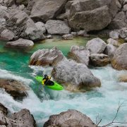
The South Fork of the Mills is a rarely run gem in the heart of Pisgah National Forest. It features classic Western North Carolina scenery and good whitewater. It is the only stream around that lacks difficult and dangerous whitewater while draining a remote gorge. The area is also steeped in history. The put-in is only a few miles from George Vanderbilt’s Cradle of Forestry.
What Makes It Great
Paddlers will immediately notice the fantastic water quality of the South Mills due to the lack of development in the watershed. Drifting downstream, surprisingly good, pool-drop whitewater leads to an obvious horizon line. This is the sliding entrance to High Falls, a twenty-foot cascade that lands on a rock. Expert paddlers will find this waterfall intriguing at high flows, when the landing is padded.
Below High Falls, South Mills continues to deliver fun ledges, never exceeding class III. Some scouting may be necessary, primarily to look for wood.
A spectacular rock wall on river right drops straight to the water about six miles into the trip. After the wall, the river slowly mellows out as it meanders toward Turkeypen, where most boaters will take out.
If the twelve mile paddle leaves you hungry for more, consider the car-less shuttle. Run back to your car on the South Mills Trail and then climb the Cantrell Creek Trail to Horse Cove Gap. Forest Road 5018 will bring you back to the put in. The twelve mile run climbs significantly and will take a couple of hours.
Don’t try to run or bike back up the entirety of the South Mills Trail. It will be flooded during good paddling conditions.
Who is Going to Love It
Strong class III boaters are going to have the most fun on the South Mills. The whitewater is reminiscent of Spring Creek in Madison County but the river is longer and more exposed due to the isolation of the valley. Class IV paddlers will not find the river particularly challenging, but will still enjoy the solitude and beauty of the drainage. High Falls will provide entertainment for even the most jaded hair boater. The multisport athlete is going to get the most out of this run. The trail run shuttle eliminates the need to spend several hours in the car. The running will be soggy, but the trails are some of the best in Pisgah.
Directions, Parking, & Regulations
From Asheville, take 280 South to FS 297 (Turkeypen Rd). This is the Turkeypen Trailhead and the South Mills takeout. Walk the half-mile trail down to the river to ensure you don’t miss the takeout. Return to 280 and turn south toward Brevard. In five miles, turn right on 276 North and follow it 11.5 miles to FS 1206 (Yellow Gap Rd). In 3.5 miles bear right on FS 476. Follow it to the dead end where you will see the river.
Featured image provided by Adam Herzog


