Posts

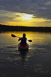
With 38 inches of annual rainfall and dam released rivers that run throughout the year, the Asheville area in Western North Carolina is one of the top paddling destinations in the United States. The laid back Blue Ridge culture compliments the surreal beauty of the mountains and the remote gorges that the rivers have cut through them.
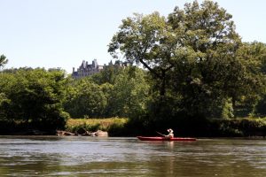
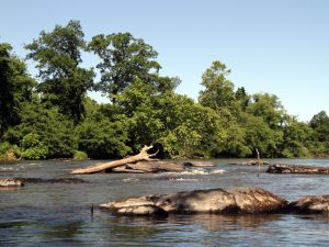
French Broad River

Paddlers enjoying the splashy class II rapids of the French Broad.

The most popular stretch of the French Broad is the 3.5-mile intermediate run between the Madison County put-in and the Stackhouse take-out. Although it won’t present much of a challenge to the expert paddler, the beauty and seclusion of this run makes it a favorite for whitewater enthusiasts across the board. Paddlers will enjoy an even distribution of splashy class II and III rapids with a few sequences and holes to keep it punchy. For a longer day, continue to the second take-out in  Hot Springs and enjoy two larger rapids along the way: Frank Bell’s (IV) and Kayaker’s Ledge (III+).

After a heavy rain, expert kayakers can tackle the challenges of the North and West Forks of the French Broad River. These two creeks have a completely different temperament than the friendly features of Section 9. Although the North Fork is considered a class IV creek, it includes two class V rapids and some mean sieves. The West Fork is solid class V with bigger drops and bigger threats than its brother. A missed line on either of these creeks could have serious consequences. Be on the lookout for the additional dangers of errant wood and lumber.
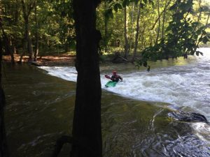
The Green River

David Clarke running Gorilla on The Green River Narrows.
Melina Coogan

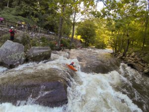
The scenic, dam-release Green River, which runs roughly 300 days out of the year, is considered the Holy Grail of whitewater in the Southeast. Three distinct sections of river offer a beautiful day of paddling for boaters of all abilities. The boulder congested Green River Narrows, a low volume, class V steep creek, serves as the main staple for advanced paddlers. Precise boat control is necessary to navigate the big slides, mandatory boofs, and tight rapids that plunge through a heavily forested gorge. Expert kayakers from across the country visit the Green to test themselves against The Big Three: Gorilla, Sunshine, and the sinisterly named Go Left or Die.

The Upper Green is an enjoyable 3.7-mile run of class III rapids. This ideal learning spot includes two challenging III+ drops: Bayless’ Boof and Pinball. The take out includes a brutal uphill hike, but for boaters who dream of one day running the Narrows, it’s well worth the cost. The mellow Lower Green is rippled with class I and II rapids for a fun and easy float. This stretch is perfect for beginners looking to log some river miles and nail their combat roll.

Big Laurel Creek

Tucked into a deep, wooded gorge, the class III/IV Big Laurel Creek provides an excellent introduction to creeking. Ambitious intermediate paddlers will love the forgiving nature and epic feel of this Appalachian gem. Dropping over 200 feet in 3.7 miles, the river offers up three major rapids linked together with tons of fun moves. The first big drop, Stairstep, is found one mile down the run and can be easily scouted on the trail on river left. Be wary of the next rapid, Suddy Hole, as the big, boxed-in hole on river right is the most dangerous feature on the run. Luckily, it can easily be avoided by a taking a clean line just right of center, off the river-wide ledge.

The run begins in Hurricane and concludes in Hot Springs, where it joins the French Broad River. From here, you can hike your boat upstream and take out at the Stackhouse or continue down the second portion of Section 9 on the French Broad. If you choose to continue, you will be faced with Windy Flats, a shallow, two mile stretch of flat water, before you’re rewarded with the two most challenging rapids of  Section 9, Frank Bell’s, and Kayaker’s Ledge.

The Nolichucky Gorge

Kayakers walking the shuttle on the Nolichucky River.
Melina Coogan

The Nolichucky River is a beautiful and playful intermediate run just over the border in Tennessee. Nearly 9 miles long, this all day adventure is perfect for a warm spring day, although when the sun drops below the gorge it can get cold fast, so pack accordingly.

You will be greeted with a series of splashy, straightforward class III rapids downstream of the railroad trestle at the put in. The first major drop, a bouncy chute known as On the Rocks, has a clean line straight down the tongue. After this, you will find a set of waves and a big, juicy hole called Jaws, one of the best play spots in the area. Make sure you’re aware of the water levels, as this normally friendly hole can get sticky above 2,000 CFS. Your next big drop will be Quarter Mile, by far the most dangerous of the river. This class IV rapid culminates in a nasty, recirculating pourover called Murphy’s Ledge. There is a solid eddy above the rapid and its entire length can be scouted from the train tracks. From here, the river mellows out with more fun class III and small waves, the perfect playground for anyone just learning to surf.

 Pigeon River

Erich Burton surfs the play hole on the Pigeon River.
Melina Coogan

The Pigeon River is the next step for the progressing kayaker after they have mastered Section 9 of the French Broad. This five mile run winds along the Eastern boundary of Great Smoky Mountain National Park. It is packed with big water class III-III+ rapids with names like Roller Coast, Accelerator, and Powerhouse. Pushy, bouncy waves make for a thrilling but not too threatening ride for intermediate paddlers. The single class IV rapid, Lost Guide, has a juicy hole that can be sneaked on the side. Play boaters will have their pick of features for surfing and wave wheals.

This river is dam released; the water is turned on from 11:30 am to 6pm. Because of its popularity and easy accessibility, you will probably find yourself surrounded by many others enjoying themselves in rafts and kayaks. This is a recent occurrence in the river’s history: for the majority of the 20th century, severely polluted from a paper mill, the Pigeon was declared biologically dead. It was even known to locals as The Dirty Bird. It wasn’t until the early-2000s, when fish, snails, and mussels were reintroduced to the waters, that the river came back to life. Soon after, paddlers flocked to this once abandoned river, although it is still threatened by contamination.

JOIN OUR NEWSLETTER

Featured image provided by Melina Coogan

The South Fork of the Mills is a rarely run gem in the heart of Pisgah National Forest. It features classic Western North Carolina scenery and good whitewater. It is the only stream around that lacks difficult and dangerous whitewater while draining a remote gorge. The area is also steeped in history. The put-in is only a few miles from George Vanderbilt’s Cradle of Forestry.

What Makes It Great

Paddlers will immediately notice the fantastic water quality of the South Mills due to the lack of development in the watershed. Drifting downstream, surprisingly good, pool-drop whitewater leads to an obvious horizon line. This is the sliding entrance to High Falls, a twenty-foot cascade that lands on a rock. Expert paddlers will find this waterfall intriguing at high flows, when the landing is padded.

Below High Falls, South Mills continues to deliver fun ledges, never exceeding class III. Some scouting may be necessary, primarily to look for wood.

A spectacular rock wall on river right drops straight to the water about six miles into the trip. After the wall, the river slowly mellows out as it meanders toward Turkeypen, where most boaters will take out.

If the twelve mile paddle leaves you hungry for more, consider the car-less shuttle. Run back to your car on the South Mills Trail and then climb the Cantrell Creek Trail to Horse Cove Gap. Forest Road 5018 will bring you back to the put in. The twelve mile run climbs significantly and will take a couple of hours.

Don’t try to run or bike back up the entirety of the South Mills Trail. It will be flooded during good paddling conditions.

Who is Going to Love It

Strong class III boaters are going to have the most fun on the South Mills. The whitewater is reminiscent of Spring Creek in Madison County but the river is longer and more exposed due to the isolation of the valley. Class IV paddlers will not find the river particularly challenging, but will still enjoy the solitude and beauty of the drainage. High Falls will provide entertainment for even the most jaded hair boater. The multisport athlete is going to get the most out of this run. The trail run shuttle eliminates the need to spend several hours in the car. The running will be soggy, but the trails are some of the best in Pisgah.

Directions, Parking, & Regulations

From Asheville, take 280 South to FS 297 (Turkeypen Rd). This is the Turkeypen Trailhead and the South Mills takeout. Walk the half-mile trail down to the river to ensure you don’t miss the takeout. Return to 280 and turn south toward Brevard. In five miles, turn right on 276 North and follow it 11.5 miles to FS 1206 (Yellow Gap Rd). In 3.5 miles bear right on FS 476. Follow it to the dead end where you will see the river.

JOIN OUR NEWSLETTER

Featured image provided by Adam Herzog

A kayak or paddle board can provide years of great times on the water. Choosing the right one can be a challenge. In addition to free community demo days on the water (like Paddlefest at Lake Julian on May 6), we also offer our demo kayaks and stand up paddle boards for rent. Through April 30, our kayaks and SUP rentals are 50% off!

Kayak and paddle board rentals are available at our flagship location in South Asheville on 1378 Hendersonville Road. They are available on a first come, first served basis and are available for flat water, whitewater, and recreational water surfaces. A complete list of our boats is available below or here.

Kayak + SUP Demo Rental Prices

  • $12.50/day, Monday-Thursday (through April 30, $25/day after)
  • $20/day, Friday-Sunday (through April 30, $40/day after)
  • A paddle and PFD are included, based on availability.
  • If you decide to purchase a boat, we’ll deduct one day’s demo rental from the price!

You’ll need an ID and credit card to rent a demo kayak or paddle board. You’ll also need to sign a release form. Save time by bringing a filled out copy with you. We do not have racks or trailers for rent, but we do sell boat straps. For FAQs, click here.


Fishing Kayak Rentals

  • Native Propel Pedal Drive 501
  • Native Slayer Propel 10
  • Native Titan Propel 10.5
  • Native Titan Propel 12
  • Native Titan Propel 13.5
  • Native Ultimate FX 13.5
  • Native Ultimate FX 12
  • Native Ultimate FX 15
  • Native Slayer 12
  • Native Slayer 12 Pro
  • Native Ultimate FX 15 Tandem

Recreational Kayak Rentals

  • Liquidlogic Marvel 10
  • Liquidlogic Manta Ray 12
  • Liquidlogic Coupe
  • Liquidlogic Inuit 12.5
  • Hurricane Santee 116 Sport
  • Hurricane Santee 126 Sport
  • Hurricane Skimmer 120 Propel
  • Hurricane Skimmer 116
  • Hurricane Skimmer 128
  • Hurricane Skimmer 140 Tandem

Crossover (Whitewater/Flatwater) Kayak Rentals 

  • Liquidlogic Remix XP 9
  • Liquidlogic Remix XP 10

Stand Up Paddleboards

  • Liquidlogic Versa Board

Touring Kayak Rental

  • Hurricane Sojourn 146

JOIN OUR NEWSLETTER

Image for French Broad Paddle Trail

The Nantahala River is ideally set up for intermediate paddlers. It has myriad small surf waves, forgiving eddy lines, and rapids with just enough power to challenge and entertain. There is also the capability to set up elite slalom courses through Nantahala Falls and the playhole near NOC has been tweaked through the years, hosting the Freestyle Kayaking World Championships in 2013. Combine those resources with the class IV-V options upstream and it’s easy to see why this area continues to be such a strong paddling destination.

What Makes It Great

Sections

Cascades | 0.7 miles | Class IV-V 

The Cascades are a very high quality and easily-lapped series of drops. The river channels well, allowing for a wide range of runnable flows (and some big holes at high water). Since this is a dewatered section of the Nantahala River, the Cascades run only when Whiteoak Creek is high from rain or during one of a few scheduled releases per year.

Upper Nantahala | 3.1 miles | Class III+ 

This is a scenic and busy section of river that provides a great cool down from the Cascades upstream or a way for aspiring advanced paddlers to get accustomed to more continuous whitewater. The entire section is road-scoutable, so watch out for wood. As far as flows go, the same thing applies as the Cascades. There needs to be rain or a scheduled release.

Nantahala Gorge | 7.5 miles | Class II-III 

The gorge section is also road-scoutable from nearly top to bottom and provides a beautiful and stress-free way to get into the world of whitewater. Notable rapids include Patton’s Run (right off the bat), Delebar’s Rock, Whirlpool, Quarry, Surfing Rapid, The Bump, and Nantahala Falls. The Falls represents an intimidating class III benchmark for many intermediate paddlers and the rocks are always lined with photographers and throwbags on a summer day.

Unique Experiences

Jump Rock 

About 5.5 miles into the run, you’ll see a very obvious large rock on the right (about 10 feet out of the water). It’s a great pit stop to jump or launch boats off of into the invigorating water.

SUP Surfing 

There are several great SUP surf waves on the Nantahala. The two best include one directly below the pedestrian bridge on NOC’s campus and another about two miles upstream at Surfer’s Rapid.

Eat at River’s End 

This restaurant is right next to the takeout and provides a nice après atmosphere to grab food and reflect on the day.

Directions, Parking, & Regulations

Access

Gorge Takeout

Nantahala Outdoor Center
13077 W. Hwy 19, Bryson City, NC 28713 

Gorge Put In 

Drive upstream on Hwy 19 ~7 miles
Turn L onto SR 1442/Wayah Rd.
Large USFS paved lot on left.

Upper Takeout 

Drive upstream on Hwy 19 ~7 miles
Turn L onto SR 1442/Wayah Rd.
Large USFS paved lot on left.

Upper Put In 

Continue on SR 1442/Wayah Rd. upstream for 3.3 miles.
Park at the 5th Bridge (if you hit Cascades, you’ve gone too far).

Cascades Takeout 

Continue on SR 1442/Wayah Rd. upstream for 3.3 miles.
Park at the 5th Bridge (if you hit Cascades, you’ve gone too far).

Cascades Put In

Continue on SR 1442/Wayah Rd. upstream for <1 mile.
You will see all of the drops; park at the top of the action (if you hit Whiteoak Creek, you’ve gone too far).

Important Info

JOIN OUR NEWSLETTER

Featured image provided by Malcolm Smith

Image for Nantahala River White Water Paddling

The Green River is a place that has had a large influence on the world of whitewater paddling and on many boaters’ lives. It is a highly convenient run because of its proximity to Asheville, Greenville, Charlotte, and Atlanta. Since it is a dam-released river, it also runs 300+ days a year.

Add the fact it has three sections of varying difficulties (and one of the most famous and prestigious extreme races) and you start to see why it is beloved by so many. But the truly beautiful thing about the Green is the combination of all these conveniences with an authentic wilderness experience. As soon as paddlers slip into her waters, the Green has a way of softening the sharp corners in life, and re-centering the soul.

What Makes It Great

Upper Section:

The Upper Green is a fantastic run for the class III paddler who is looking to dip her or his toes in the realm of vertical drops. Paddlers are treated to several miles of nice winding class II and III rapids and two borderline class IV drops. Notable named rapids are Bayless Boof, Wanda’s Hole, and Pinball. Take out just before Big Hungry Creek enters on the left and hike the half mile uphill to civilization.

Narrows Section:

The Narrows is arguably the most famous steep creek in the world. With a nice combination of boulder garden and bedrock rapids, this section will challenge and push the most elite of kayakers, but is also accessible (with a few portages) to the class IV+ boater. Go Left and Die, Gorilla, and Sunshine are the three major class V rapids, and there are many more drops that aren’t to be trifled with. The majority of the gradient is concentrated within the “monster mile,” which drops at a rate of 300+ feet per mile. This section lends itself well to multi-lap days.

Lower Section:

The Lower Green is the perfect beginner run. The truly bipolar river lets go of its furious descent and meanders out into a beautiful rural valley. This is a perfect section for the beginner paddler or a summer tube trip. It is completely roadside, so choose how much of the 7 miles you’d like to bite off.

Unique Experiences

Dawn Patrol:

Set shuttle in the dark and put on at first light for an unforgettable experience or great start to the work day!

Heron Viewing:

There are several Great Blue Herons that enjoy fishing the Green. On lucky days, you can quietly follow them down the river as they fly from one fishing spot to another.

Racing:

The Green Race is an experience unlike any other. For those with the skills, paddling down that incredibly challenging course and into a 1,000+ spectator amphitheater at Gorilla is something that belongs on the bucket list. This event always occurs the first Saturday in November. The Narrows get much more intense during the weeks before the race, and this is not a good time for a first-time paddler.

Disclaimer:

Please paddle within your abilities. Paddlers who step above their abilities are very easy to spot and actually endanger river access for all.

Directions, Parking, & Regulations

Access Directions:

  • Upper Takeout: From Asheville, take Interstate 26 East to Exit 22 (Hendersonville/Upward Rd). Take a left onto Upward Rd and drive 1.5 Miles and follow Big Hungry Road to Gallimore Road. Park in gated lot (see below for key info).
  • Upper Put In: From Gallimore Road/Upper Takeout, return to Interstate 26 to Exit 23 (Greenville/225/176/25). Drive 1.8 miles to Exit 176 (Saluda/East Flat Rock), turn left onto 176 and drive 2 miles. Make a left onto Pot Shoals Road. Park on the downstream side of Pot Shoals Bridge.
  • Narrows Takeout: From Asheville, take Interstate 26 East to Exit 59 (Saluda). Make a left off the ramp onto Green River Cove Road. Fishtop Access is a large gravel lot at the bottom of the hill.
  • Narrows Put In: From Asheville, take Interstate 26 East to Exit 22 (Hendersonville/Upward Rd). Take a left onto Upward Rd and drive 1.5 Miles and follow Big Hungry Road to Gallimore Road. Park in gated lot (see below for key info).
  • Lower Takeout: From Asheville, take Interstate 26 East to Exit 59 (Saluda). Take a left off the ramp onto Green River Cove Road. Note the Fishtop Access gravel lot on left at the bottom of the hill. Drive an additional 6 miles to theBig Rock Take-Out gravel lot on left.
  • Lower Put In: From Asheville, take Interstate 26 East to Exit 59 (Saluda). Make a left off the ramp onto Green River Cove Road. Fishtop Access is a large gravel lot at the bottom of the hill.

Important Info:

  • River Gauge: A few rapids below the Narrows put in, you will find a stick gauge. A good minimum on this gauge is 6″. A healthy 100% flow is 9″ and 17″ is 200%. Paddlers have ventured into the Narrows at up to around 36 inches, but the consequence factor becomes exponentially larger as the water goes up. Also, please note that there is no alcohol within 50 feet of the river.
  • Water Schedule: Since this is a dam-released river, it’s important to understand water schedules. 
    • Water to Upper Takeout/Narrows Putin (2.5 hours)
    • Water to Narrows Takeout/Lower Putin (4.25 hours)
    • Water to Lower Takeout (6.5 hours)
    • Water empties faster than it fills. Don’t put in at the Narrows more than 1.25 hours after the dam shuts off.

JOIN OUR NEWSLETTER

Featured image provided by Melina Coogan

Image for Green River

The French Broad Paddle Trail is a series of campsites along the French Broad River connecting over 140 miles of river. It was created by MountainTrue, a non-profit in Western North Carolina that houses the French Broad Riverkeeper, who works to protect and promote the quality of the French Broad River and its tributaries. The paddle trail begins in Rosman, NC, taking paddlers over flat and whitewater. It passes through an incredibly beautiful geographical region of the Southeast.

What Makes It Great

The Cherokee used to call it the “Long Man,” and its tributaries, “Chattering Children.” Later, European settlers deemed it the “French Broad.” The world’s third oldest river has a majestic and ancient appeal. Flat water and whitewater paddlers alike will love the adventure the French Broad Paddle Trail provides. You can now paddle over 140 miles of the river from Rosman in North Carolina to Douglas Lake in Tennessee, staying at campsites all along the way.

The river begins in an area of rolling, shaded farmland, where the North and West Forks come together. As the river plunges through Pisgah and Cherokee National Forests, it eventually opens up to reveal mountains rising out of the water’s edge. The river is perfect for all skill levels, with the first 75 miles consisting of mainly flat water paddling and the rest offering a mix of class I, II, and III rapids. You can easily spend one night or even several weeks exploring one of the world’s oldest rivers.

Starting in Rosman, the French Broad runs northwest through the funky and quaint Western North Carolinian towns of Brevard, Asheville, Woodfin. Weaverville, Marshall, and Hot Springs, as well as Del Rio and Newport in Tennessee. What’s great about this part of the country is the small town feel with an eclectic charm of mountain culture.

Who is Going to Love It

History and nature buffs. Some sections of the French Broad River make you feel like you’re in a prehistoric time. Other times, you’ll see a bald eagle and feel like singing the Star Spangled Banner. Still other times, you’ll float through a town and wonder how that place has been shaped by the river…and vice versa.

Directions, Parking, & Regulations

Visit French Broad River Paddle’s website for all your logistical needs. At the website you can make a reservation, look at a map, find access points, or read about the campsites. Campsites are $25/night, with no limit on the number of your entourage. Plan your trip ahead of time and know your river. There are three dams on the French Broad, and we discourage portaging all of them. These portages are very time-consuming and oftentimes dangerous. Try to plan your trip where you take out before these dams. Local Asheville outfitters Diamond Brand Outdoors and Frugal Backpacker.

The French Broad Paddle Trail is open 365 days a year. Campsites are strategically placed, so that paddlers can reach their sites within a single day. The longest distance between sites is 15 miles. The campsites are paddle-in only, meaning you’ll be far away from car-camping glampers. Remember these campsites are paddle-in sites, so don’t leave a bunch of litter after your stay. It makes it very difficult for volunteers and French Broad River Paddle employees to clean up when they’re already carrying lawn mowers and weed-eaters to do maintenance. So, practice leave-no-trace principles wherever you go, and have a great paddle.

JOIN OUR NEWSLETTER

Featured image provided by anoldent

Primarily a popular whitewater rafting destination, the Pigeon River is a dam controlled river that winds its way through North Carolina and Eastern Tennessee before emptying into the French Broad River.

What Makes It Great

Situated along the Smoky Mountains, the Pigeon River provides beautiful views as you make your way. Paddlers along the Upper Pigeon will brag about the famous whitewater encountered — Roller Coaster, Powerhouse, Lost Guide, and many more that will keep your energy high and your skills tested. The Lower Pigeon provides a much better experience for the paddler wanting to become more comfortable with intermediate whitewater, with many calm sections and rapids from class II/III.The Pigeon River has impressively overcome quite a bit of environmental damage over the last two decades. It used to be an extremely polluted waterway with rapidly decreasing biodiversity, but now it has healthy fish populations (which anglers take advantage of) and a growing recreational presence.

Who is Going to Love It

For thrill seekers and more experience paddlers, you’ll want to choose the Upper section of the Pigeon because it has a lot of fun play spots and about five miles of Class II-III+ rapids. For novice paddlers or those simply looking to soak up the scenery, the Lower section of the Pigeon provides four miles of family friendly flat water where swimming is encouraged.

Directions, Parking, & Regulations

Public access along the river is primarily limited to bridge crossings and small pull-offs along the roads paralleling the river. There are a few primitive launching areas for canoes and other small boats.For the Upper Pigeon- Parking can be found by taking I-40 to exit 451, taking the bridge and turning up river. Take Waterville Road and you will see a parking area/put it. More information can be found here. For the Lower Pigeon, head towards Hartford, and park at any of the put-ins near the rafting outfitters.

JOIN OUR NEWSLETTER

Featured image provided by Jared

Events

Nothing Found

Sorry, no posts matched your criteria